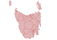
North West Tasmania
About the profile areas
The 2023 Estimated Resident Population for North West Tasmania is 119,790, with a population density of 5.19 persons per square km.
Location and boundaries
The North West Tasmania Region is bounded by Bass Strait in the north, south and west, and the West Tamar Council area, the Meander Valley Council area, the Central Highlands Council area, the Derwent Valley Council area and the Huon Valley Council area in the east.
Important
|
Population119,790 2023 ABS ERP |
Land area23,065 square km |
Population density5.19 persons per square km |
Settlement history
European settlement of the Region dates from 1822, when a penal colony was established on Sarah Island. Early industries included boat building, fishing, timber-getting and farming. Population was minimal until the 1850s when coal was discovered and several townships were established. Growth took place from the late 1800s into the early 1900s, spurred by mining, industrial growth, increased farming and improved access. Significant population growth occurred from the post-war years into the early 1970s, with the population increasing from under 61,000 in 1947 to about 100,000 in 1971. More moderate growth took place during the 1970s and 1980s. The population declined slightly during the late 1990s, falling from about 106,000 in 1996 to about 102,000 in 2001, largely due to major changes in the mining, manufacturing, forestry and hydro-electric industries. The population then increased from the early 2000s, rising to nearly 107,000 in 2011. Recent growth has been predominantly in the municipalities closest to Devonport (Latrobe Council area, Devonport City, Burnie City, Kentish Council area and Central Coast Council area).
Land use
The North West Tasmania Region features both urban and rural areas. The urban areas include residential, industrial and commercial land use. More than 75% of the Region’s population is concentrated in the towns and cities along the coastal strip between Wynyard and Latrobe, with the two major centres being Burnie and Devonport. Smaller townships are located at Latrobe, Penguin, Port Sorell, Queenstown, Railton, Rosebery, Sheffield, Smithton, Somerset, Stanley, Strahan, Tullah, Ulverstone, Waratah, Wynyard and Zeehan. Rural land is used largely for agriculture (particularly dairy and beef farming and vegetable and crop growing, with some poppy and pyrethrum growing), and timber production. Mining and tourism are also important industries. The North West Tasmania Region encompasses a total land area of nearly 23,000 square kilometres. The LGA with the largest population in the Region is Devonport City, with the King Island Council area having the smallest population.
Transport
The North West Tasmania Region is served by the Bass Highway, the Lyell Highway, the Murchison Highway, the Ridgley Highway, the Zeehan Highway, the Spirit of Tasmania Ferry, Devonport Port and the Port of Burnie.
Major features
- Major features of the Region include the Tasmanian Wilderness World Heritage Area,
- Cradle Mountain-Lake St Clair National Park,
- Franklin-Gordon Wild Rivers National Park,
- Narawntapu National Park,
- Rocky Cape National Park,
- Savage River National Park,
- Southwest National Park,
- Arthur-Pieman Conservation Area,
- The Tarkine Wilderness,
- The Nut State Reserve,
- Hellyer Gorge,
- Leven Canyon,
- Gunns Plains Cave,
- Cradle Mountain,
- Mount Roland,
- The Franklin River,
- The Gordon River,
- Macquarie Harbour,
- Lake Barrington,
- Lake Burbury,
- West Coast Wilderness Railway,
- Don River Railway & Museum,
- Tasmazia,
- Wing’s Wildlife Park,
- Bass Strait Maritime Centre,
- Stanley Seaquarium,
- Little Penguin Observation Centre,
- Australian Axeman’s Hall of Fame,
- House of Anvers Chocolate,
- Devonport Entertainment & Convention Centre,
- Arthur River Cruises,
- Gordon River Cruises,
- Pieman River Cruises,
- Stanley Seal Cruises,
- Tarkine Forest Adventures (Dismal Swamp),
- TasTAFE (Burnie,
- Devonport and Smithton Campuses),
- University of Tasmania (Cradle Coast Campus),
- North West Regional Hospital,
- Mersey Community Hospital,
- Smithton District Hospital,
- King Island and a number of smaller islands,
- Woolnorth Wind Farm,
- Cape Grim Baseline Air Pollution Station,
- and numerous museums,
- wineries,
- golf clubs,
- gardens,
- state forests,
- waterfalls,
- lighthouses,
- lookouts and beaches.
Included areas
- The North West Tasmania Region includes nine local government areas: Burnie City,
- Central Coast Council area,
- Circular Head Council area,
- Devonport City,
- Kentish Council area,
- King Island Council area,
- Latrobe Council area,
- Waratah-Wynyard Council area and West Coast Council area.
