Bellingen Shire
About the profile areas
The 2023 Estimated Resident Population for Bellingen Shire is 13,231, with a population density of 8.26 persons per square km.
Location and boundaries
Bellingen Shire is located on the Mid North Coast of New South Wales, about 550 kilometres north of Sydney and 400 kilometres south of Brisbane. Bellingen Shire is bounded by Coffs Harbour City in the north, the Coral Sea in the east, Nambucca Shire in the south, and the Armidale Regional Council area and the Clarence Valley Council area in the west.
Traditional Owners
The original inhabitants of the Bellingen area were the Gumbaynggirr Aboriginal people.
Name origin
Bellingen is thought to be named from a word meaning "cheeky fellow" or "a loud mouth person who talks too much".
Important
|
Population13,231 2023 ABS ERP |
Land area1,602 square km |
Population density8.26 persons per square km |
Settlement history
European settlement dates from the 1830s, with land used mainly for timber cutting and sheep grazing. Population was minimal until the 1860s. Growth took place during the late 1800s and early 1900s, particularly in the township of Bellingen. Land then became used more for dairy farming. Growth resumed from the 1970s, with the population of the Shire growing from about 7,200 in 1976 to over 10,000 in 1986, and then to about 11,700 in 1991. The population increased slightly to about 12,000 in 1996, and then was relatively stable to 2011.
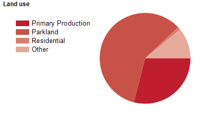
Land use
Bellingen Shire is a predominantly rural area, with several small townships and villages. The main townships are Bellingen and Urunga, with a smaller township at Dorrigo, and villages at Fernmount, Mylestom, Raleigh and Repton. The Shire encompasses a total land area of about 1,600 square kilometres, with more than half of the land being national parks and state forests. Rural land is used largely for dairy farming, timber production and potato growing. Tourism is also an important industry.
Transport
The Shire is served by the Pacific Highway, Waterfall Way and the north coast railway line.
Major features
- Major features of the Shire include Bellinger River National Park,
- Bindarri National Park,
- Bongil Bongil National Park,
- Cascade National Park,
- Dorrigo National Park,
- Junuy Juluum National Park,
- New England National Park,
- Nymboi-Binderay National Park,
- Bagul Waajaarr Nature Reserve,
- Deer Vale Nature Reserve,
- Ganay Nature Reserve,
- Jaaningga Nature Reserve,
- Juugawaarri Nature Reserve,
- Muldiva Nature Reserve,
- Dangar Falls,
- Dorrigo Rainforest Centre,
- Dorrigo Steam Railway & Museum,
- Bellingen Museum,
- Urunga Museum,
- Raleigh International Raceway,
- Bellingen Golf Club,
- Dorrigo Memorial RSL & Golf Club,
- Urunga Golf & Sports Club,
- Bellingen Island Reserve,
- Bellingen Park,
- Dorrigo Recreation Reserve,
- Urunga Recreation Reserve,
- Bellingen Hospital,
- The Bellinger River,
- The Kalang River and two wineries.
Included areas
- Bellingen Shire includes the townships and localities of Bellingen,
- Bielsdown Hills,
- Bostobrick,
- Brierfield,
- Brinerville (part),
- Cascade,
- Darkwood,
- Deer Vale,
- Dorrigo,
- Dorrigo Mountain,
- Fernbrook,
- Fernmount,
- Gleniffer,
- Kalang,
- Kennaicle Creek (part),
- Megan,
- Mylestom,
- Never Never,
- North Dorrigo,
- Raleigh,
- Repton,
- Spicketts Creek,
- Tallowwood Ridge,
- Thora,
- Urunga,
- Valery and Valla (part).