City of Yarra
About the profile areas
The 2023 Estimated Resident Population for the City of Yarra is 97,448, with a population density of 4,990 persons per square km.
Location and boundaries
The City of Yarra is located in Melbourne's inner-northern suburbs, about 4 kilometres north-east of the Melbourne CBD. The City of Yarra is bounded by the City of Moreland, the City of Darebin and the City of Banyule in the north, the Yarra River and the City of Boroondara in the east, the Yarra River and the City of Stonnington in the south, and the City of Melbourne in the west.
Traditional Owners
The original inhabitants of the City of Yarra were the Wurundjeri Aboriginal people.
Name origin
The City of Yarra is thought to be named from the Aboriginal words "Yarra Yarra", meaning ever flowing (river).
Important
|
Population97,448 2023 ABS ERP |
Land area19.53 square km |
Population density4,990 persons per square km |
Settlement history
European settlement dates from the 1830s when settlers lived along the Yarra River. Significant development occurred in the 1880s and 1890s when industry had a strong presence in the area and working class housing dominated the dwelling stock. There was considerable development in the post-war years when many migrants moved into the area and public housing estates (including high-rise) were built. The population declined during the 1960s and 1970s. From the 1980s significant parts of the municipality have been redeveloped and gentrified, which has attracted more young, single, professional, tertiary educated, middle to high income residents in the area. The population began to increase from the 1990s, with rapid growth in more recent years.
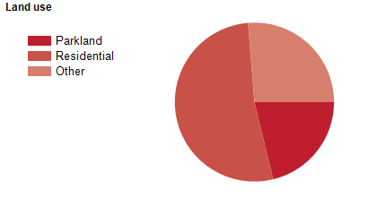
Land use
The character of the City of Yarra reflects this varied history with a mixture of residential, industrial and commercial areas. The main industries include beer and clothing manufacturing and machinery and equipment wholesaling. Commercial areas are concentrated along several of the main roads. There is a mix of housing types, with private homes, public and community housing and a variety of private rental properties. Many of the traditional stock of rooming houses have been converted into private accommodation, hotels and backpacker accommodation in recent years. The City is known for its extensive community services infrastructure and it contains a highly multi-cultural population. The City encompasses a total land area of about 20 square kilometres.
Transport
The City of Yarra is served by Citylink, the Eastern Freeway, Alexandra Parade, Hoddle Street, the Alamein, Belgrave, Glen Waverley, Hurstbridge, Lilydale and South Morang railway lines, and several tram lines.
Major features
- Major features of the City of Yarra include the Yarra River,
- Yarra Bend Park,
- Edinburgh Gardens,
- Darling Gardens,
- Collingwood Children's Farm,
- Yarra Bend Public Golf Course,
- Victoria Park Football Ground,
- Abbotsford Convent,
- St Vincent's Hospital Melbourne,
- Epworth Hospital Richmond,
- The University of Melbourne (Burnley Campus),
- Melbourne Polytechnic (Collingwood and Fairfield Campuses),
- Kangan Institute (Richmond Campus),
- Victoria Gardens Shopping Centre and shopping strips at Bridge Road (Richmond),
- Victoria Street (Richmond/Abbotsford),
- Brunswick Street (Fitzroy) and Smith Street (Collingwood/Fitzroy).
Included areas
- The City of Yarra includes the suburbs of Abbotsford,
- Alphington (part),
- Burnley,
- Carlton North (part),
- Clifton Hill,
- Collingwood,
- Cremorne,
- Fairfield (part),
- Fitzroy,
- Fitzroy North (part),
- Princes Hill and Richmond.