Sunshine Coast
About the profile areas
The 2023 Estimated Resident Population for Sunshine Coast is 365,942, with a population density of 159.8 persons per square km.
Location and boundaries
The Sunshine Coast Council area is located in south-east Queensland, about 100 kilometres north of the Brisbane CBD. The Sunshine Coast Council area is bounded by the Gympie Regional Council area in the north-west, Noosa Shire in the north-east, the Coral Sea in the east, the Moreton Bay Regional Council area in the south, and the Somerset Regional Council area in the south-west.
Traditional Owners
The original inhabitants of the Sunshine Coast Council area were the Kabi Kabi and Jinibara Aboriginal people.
Name origin
The Sunshine Coast was named to describe the area during the 1960s to aid in the promotion of tourism. It was originally known as North Coast.
Important
|
Population365,942 2023 ABS ERP |
Land area2,291 square km |
Population density159.8 persons per square km |
Settlement history
European settlement dates from the 1850s, with land used mainly for grazing and timber-getting. Population was minimal until the 1860s, when several townships were established and agriculture, including sugar-cane growing, became more popular. Growth took place from the late 1800s into the early 1900s, spurred by the opening of the railway line between Brisbane and Gympie in 1891. Land was then used for fruit growing and dairy farming. Expansion continued during the 1920s and 1930s, aided by tourism and improved access. Significant development occurred during the post-war years, particularly from the late 1960s, with the population of the Council area increasing from about 21,000 in 1947 to about 36,000 in 1971. Rapid growth took place during the 1970s and 1980s, with the population rising to about 98,000 in 1986. The population continued to increase rapidly from the 1990s.
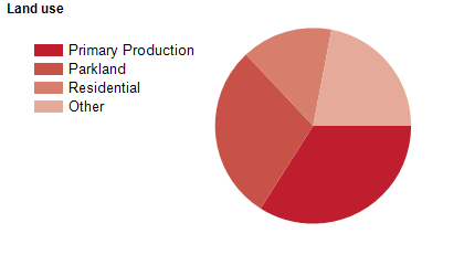
Land use
The Sunshine Coast Council area is a rapidly growing residential and tourist area, with substantial rural, rural-residential and parkland areas. The Council area encompasses a total land area of about 2,290 square kilometres, including significant beaches, coastline, waterways, national parks, state forests and bushland. The Council area includes coastal urban centres and inland towns. Tourism is a major industry with many resorts and holiday accommodation places. Much of the rural area is used for dairy farming, cattle grazing and crop growing.
Transport
The Sunshine Coast Council area is served by the Bruce Highway, the Sunshine Motorway, Sunshine Coast Airport and the Sunshine Coast railway line.
Major features
- Major features of the Sunshine Coast Council area include numerous National Parks (Bribie Island,
- Conondale,
- Dularcha,
- Eudlo Creek,
- Ferntree Creek,
- Glass House Mountains,
- Kondalilla,
- Mapleton,
- Mapleton Falls,
- Mooloolah River,
- Mount Coolum,
- Noosa and Triunia),
- Pumicestone Passage Marine Park,
- Sunshine Coast Institute of TAFE (Maroochydore,
- Mooloolaba and Nambour Campuses),
- University of the Sunshine Coast (Sippy Downs Campus),
- Sunshine Coast Health Institute,
- Sunshine Coast University Hospital,
- Aussie World,
- Australia Zoo,
- Sunshine Castle,
- The Ginger Factory,
- Nutworks,
- SEA LIFE Sunshine Coast,
- Mooloolaba Wharf & Marina,
- Sunshine Coast Stadium,
- Lake Baroon,
- Cooloolabin Dam,
- Ewen Maddock Dam,
- The Maroochy River,
- The Mooloolah River,
- Maroochy Regional Bushland Botanic Garden,
- Maroochy Wetlands Sanctuary,
- Mary Cairncross Scenic Reserve,
- and numerous golf courses,
- shopping centres,
- wineries and beaches.
Included areas
- The Sunshine Coast Council area includes the localities of Alexandra Headland,
- Aroona,
- Bald Knob,
- Balmoral Ridge,
- Baringa,
- Battery Hill,
- Beerburrum,
- Beerwah,
- Belli Park,
- Bells Creek,
- Birtinya,
- Bli Bli,
- Bokarina,
- Booroobin (part),
- Bribie Island North,
- Bridges,
- Buddina,
- Buderim,
- Burnside,
- Caloundra,
- Caloundra West,
- Cambroon,
- Chevallum,
- Coes Creek,
- Conondale,
- Coochin Creek,
- Coolabine,
- Cooloolabin,
- Coolum Beach,
- Crohamhurst,
- Curramore,
- Currimundi,
- Diamond Valley,
- Dicky Beach,
- Diddillibah,
- Doonan (part),
- Dulong,
- Eerwah Vale,
- Elaman Creek,
- Eudlo,
- Eumundi,
- Flaxton,
- Forest Glen,
- Gheerulla,
- Glass House Mountains,
- Glenview,
- Golden Beach,
- Highworth,
- Hunchy,
- Ilkley,
- Image Flat,
- Kenilworth,
- Kiamba,
- Kidaman Creek,
- Kiels Mountain,
- Kings Beach,
- Kulangoor,
- Kuluin,
- Kunda Park,
- Kureelpa,
- Landers Shoot,
- Landsborough,
- Little Mountain,
- Maleny,
- Mapleton,
- Marcoola,
- Maroochy River,
- Maroochydore,
- Meridan Plains,
- Minyama,
- Moffat Beach,
- Mons,
- Montville,
- Mooloolaba,
- Mooloolah Valley,
- Mount Coolum,
- Mount Mellum,
- Mountain Creek,
- Mudjimba,
- Nambour,
- Ninderry,
- North Arm,
- North Maleny,
- Obi Obi,
- Pacific Paradise,
- Palmview,
- Palmwoods,
- Parklands,
- Parrearra,
- Peachester,
- Pelican Waters,
- Peregian Beach (part),
- Peregian Springs,
- Perwillowen,
- Point Arkwright,
- Reesville,
- Rosemount,
- Shelly Beach,
- Sippy Downs,
- Tanawha,
- Towen Mountain,
- Twin Waters,
- Valdora,
- Verrierdale,
- Warana,
- West Woombye,
- Weyba Downs,
- Witta,
- Woombye,
- Wootha,
- Wurtulla,
- Yandina,
- Yandina Creek and Yaroomba.