Kempsey Shire
About the profile areas
The 2023 Estimated Resident Population for Kempsey Shire is 31,453, with a population density of 9.31 persons per square km.
Location and boundaries
Kempsey Shire is located on the Mid North Coast of New South Wales, about 400 kilometres north of the Sydney CBD and 400 kilometres south of the Brisbane CBD. Kempsey Shire is bounded by Nambucca Shire in the north, the Coral Sea in the east, the Port Macquarie-Hastings Council area in the south, and the Walcha Council area and the Armidale Regional Council area in the west.
Traditional Owners
The original inhabitants of the Kempsey area were the Dunghutti Aboriginal people.
Name origin
Kempsey Shire is named after the valley of Kempsey in Worcestershire, England. The area is also known as the Macleay Valley Coast.
Important
|
Population31,453 2023 ABS ERP |
Land area3,379 square km |
Population density9.31 persons per square km |
Settlement history
European settlement dates from 1827 with the first land grants made in 1835. Land was used mainly for grazing, dairy farming and timber getting. Growth took place during the late 1800s, particularly in and around the township of Kempsey. Expansion continued during the early 1900s, aided by the opening of the railway line. Significant growth occurred from the 1970s, with the population of the Shire increasing from about 11,000 in 1971 to 17,000 in 1976, and then to about 23,000 in 1986. The population continued to increase from the 1990s, rising to about 25,000 in 1991, to 27,000 in 2001, and then to about 28,500 in 2011. Recent growth has been prominent in South West Rocks. Population growth is expected to continue.
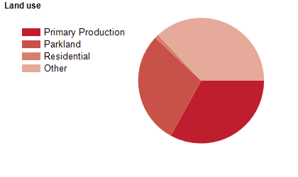
Land use
Kempsey Shire is a predominantly rural area, with numerous inland and coastal townships. The Shire encompasses a total land area of nearly 3,400 square kilometres. The largest town is Kempsey, with smaller townships at Crescent Head, Frederickton, Gladstone, Hat Head, Smithtown, South West Rocks and Stuarts Point, and small villages at Bellbrook, Grassy Head, Jerseyville, Kinchela, Kundabung and Willawarrin. Rural land is used largely for dairy farming and timber production, with tourism, horticulture and fishing also being important industries.
Transport
Kempsey Shire is served by the Pacific Highway, Kempsey Airport and the north coast railway line.
Major features
- Major features of the Shire include Arakoon National Park,
- Carrai National Park,
- Goolawah National Park,
- Hat Head National Park,
- Kumbatine National Park,
- Limeburners Creek National Park,
- Maria National Park,
- New England National Park,
- Willi Willi National Park,
- Yarrahappini Wetlands National Park,
- Yarriabinni National Park,
- Boonanghi Nature Reserve,
- Fifes Knob Nature Reserve,
- Fishermans Bend Nature Reserve,
- Gads Sugarloaf Nature Reserve,
- Skillion Nature Reserve,
- The Castles Nature Reserve,
- Willi Willi Caves Nature Reserve,
- Yarravel Nature Reserve,
- numerous state forests,
- Carrai State Conservation Area,
- Clybucca Historic Site,
- Trial Bay Gaol,
- Smoky Cape Lighthouse,
- Macleay River Historical Society Museum,
- Slim Dusty Centre,
- Wigay Aboriginal Culture Park,
- Kempsey Township,
- Kempsey District Hospital,
- North Coast TAFE (Kempsey Campus),
- Dangars Creek Vineyard,
- Sherwood Estate Winery,
- The Macleay River and numerous beaches.
Included areas
- Kempsey Shire includes the townships and localities of Aldavilla,
- Arakoon,
- Austral Eden,
- Barraganyatti,
- Bellbrook,
- Bellimbopinni,
- Belmore River,
- Burnt Bridge,
- Clybucca,
- Collombatti,
- Comara,
- Cooperabung (part),
- Corangula,
- Crescent Head,
- Deep Creek,
- Dondingalong (part),
- East Kempsey,
- Euroka,
- Fishermans Reach,
- Frederickton,
- Gladstone,
- Grassy Head,
- Greenhill,
- Hampden Hall,
- Hat Head,
- Hickeys Creek,
- Jerseyville,
- Kempsey,
- Kinchela,
- Kundabung (part),
- Millbank,
- Mooneba,
- Moparrabah,
- Mungay Creek,
- Old Station,
- Pola Creek,
- Rainbow Reach,
- Seven Oaks,
- Sherwood,
- Skillion Flat,
- Smithtown,
- South Kempsey,
- South West Rocks,
- Stuarts Point,
- Summer Island,
- Temagog,
- Toorooka,
- Turners Flat,
- Verges Creek,
- West Kempsey,
- Willawarrin,
- Willi Willi,
- Wittitrin,
- Yarrahapinni,
- Yarravel and Yessabah.