Glenorchy City
About the profile areas
The 2023 Estimated Resident Population for Glenorchy City is 50,808, with a population density of 420.1 persons per square km.
Location and boundaries
Glenorchy City is located in southern Tasmania, about 7 kilometres north of the Hobart CBD. Glenorchy City is bounded by the Derwent River in the north and east, Hobart City in the south-east, the Kingborough Council area in the south and the Derwent Valley Council area in the west.
Traditional Owners
The original inhabitants of the Glenorchy area were the Mouheeneener Aboriginal people.
Name origin
Glenorchy is thought to be named by Governor Lachlan Macquarie after a Scottish village on the Orchy River in Scotland, with the prefix "Glen" thought to be derived from a Gaelic word meaning “tumbling waters”.
Important
|
Population50,808 2023 ABS ERP |
Land area120.9 square km |
Population density420.1 persons per square km |
Settlement history
European settlement dates from 1804 when the first land grant was made. By the 1820s, Glenorchy was characterised by farming and rural living. The 1840s and 1850s were periods of steady growth, with the area proclaimed a municipality in 1864. A coach road ran to Hobart and a ferry across the Derwent River went to Risdon. The railway was connected to Glenorchy in the 1870s. Orcharding became a significant industry, with the first coolstore built in the 1880s. In 1911 the population was nearly 3,400. Glenorchy remained a predominantly rural settlement until after World War I, with the establishment of the Electrolytic Zinc Company (now Nyrstar) at Lutana, and the Cadbury confectionery factory at Claremont. Industrial development began to take over from farming and orcharding from the 1920s, although the area continued to remain a grain, fruit and hop growing district until the 1940s. Significant industrial and residential development occurred in the post-war years, including several public housing estates. By 1947 the population had grown to more than 14,000. Development was facilitated by the construction of the Brooker Highway in 1952. By 1961 the population had grown to more than 35,000, with Glenorchy declared a City in 1964. The last orchards were subdivided in 1972. Between the 1970s and the late 1990s the City's population was relatively stable at over 40,000 people. The population then increased marginally, rising from about 42,000 in 2001 to about 44,000 in 2011.
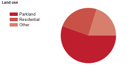
Land use
Glenorchy City features both urban and semi-rural areas, with mostly undulating hills rising steeply in the west to a line of hills. Glenorchy is characterised by a diverse mix of industrial, commercial and residential development. Industries in the City include ship building, metal fabrication, zinc processing, food processing, furniture production and more recently, high technology industry. The City encompasses a total land area of about 120 square kilometres.
Transport
Glenorchy City is served by the Brooker Highway.
Major features
- Major features of the City include the Derwent River,
- The Cadbury Factory,
- Moorilla Winery,
- Museum of Old and New Art (MONA),
- The Glenorchy CBD,
- Tasmanian Transport Museum,
- Royal Hobart Showgrounds,
- Derwent Entertainment Centre,
- Moonah Arts Centre,
- Claremont Golf Club,
- Elwick Racecourse,
- King George V Park,
- Glenorchy Art and Sculpture Park,
- Tolosa Park,
- Tasmanian Polytechnic (Bender Drive Campus) and Nyrstar Hobart Smelter.
Included areas
- Glenorchy City includes the suburbs and localities of Austins Ferry,
- Berriedale,
- Chigwell,
- Claremont (part),
- Collinsvale (part),
- Derwent Park,
- Dowsing Point,
- Glenlusk (part),
- Glenorchy,
- Goodwood,
- Granton (part),
- Lutana,
- Montrose,
- Moonah,
- Rosetta,
- Wellington Park (part) and West Moonah.