East Gippsland Shire
About the profile areas
The 2023 Estimated Resident Population for the East Gippsland Shire is 49,179, with a population density of 2.35 persons per square km.
Location and boundaries
East Gippsland Shire is located in eastern Victoria, between 280 and 550 kilometres from the Melbourne CBD. East Gippsland Shire is bounded by Towong Shire, the New South Wales border, the Snowy Valleys Council area, the Snowy Monaro Regional Council area and Bega Valley Shire in the north, the Tasman Sea and Bass Strait in the east and south, Wellington Shire in the south-west, and Alpine Shire in the north-west.
Traditional Owners
The original inhabitants of the East Gippsland Shire were the Ganai Aboriginal people.
Name origin
East Gippsland Shire is named for the eastern part of Gippsland, which was named after Sir George Gipps, former NSW Governor.
Important
|
Population49,179 2023 ABS ERP |
Land area20,931 square km |
Population density2.35 persons per square km |
Settlement history
European settlement dates from the 1830s, with land used mainly for sheep and cattle grazing and timber-getting. Growth took place in the 1850s and 1860s, spurred by gold discoveries. More substantial development took place from the 1880s as settlement spread into the more marginal forests and hills. Expansion continued during the early 1900s. Growth continued during the post-war years. The population generally increased gradually from the 1990s.
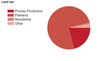
Land use
East Gippsland Shire is a predominantly rural area, with many townships and small communities. The population is unevenly distributed, with a concentration around the Gippsland Lakes in the south-west, and relatively sparsely settled areas elsewhere. The largest commercial centre is Bairnsdale, while the largest tourist centre is Lakes Entrance. Other significant townships include Orbost, Paynesville, Omeo, Mallacoota and Metung. The Shire encompasses a total land area of about 20,930 square kilometres, including substantial areas of national park, state park, lakes, rivers and coastal areas. Approximately 75% of the Shire is held in National and State reserves. Land is used mainly for pastoral and agricultural purposes, particularly forestry and grazing, with some vegetable growing. Fishing and tourism are also important industries.
Transport
East Gippsland Shire is served by the Monaro Highway, the Omeo Highway, the Princes Highway, the Great Alpine Road and the Melbourne-Bairnsdale railway line.
Major features
- Major features of East Gippsland Shire include the Gippsland Lakes (Lake King,
- Lake Victoria and Lake Tyers),
- numerous National Parks (Alfred,
- Alpine,
- Coopracambra,
- Croajingalong,
- Errinundra,
- Lind,
- Mitchell River,
- Snowy River and The Lakes),
- Gippsland Lakes Reserve (Backwater Morass,
- Mitchell River Silt Jetties,
- Raymond Island and Steel Bay - Newland Backwater),
- Buchan Caves Reserve (including Royal Cave and Fairy Cave),
- Cape Conran Coastal Park,
- Gippsland Lakes Coastal Park,
- Lake Tyers State Park,
- Mallacoota Inlet,
- Sydenham Inlet,
- Tamboon Inlet,
- Ninety Mile Beach,
- various other beaches,
- numerous flora and fauna reserves,
- The Bairnsdale CBD,
- Federation Training (Bairnsdale,
- Forestech and Lakes Entrance - Seamec Campuses),
- Bairnsdale Regional Health Service,
- Orbost Regional Health Service,
- The East Gippsland Rail Trail and several rivers (Bemm,
- Mitchell,
- Nicholson,
- Snowy and Tambo).
Included areas
- East Gippsland Shire includes the localities of Anglers Rest,
- Bairnsdale,
- Banksia Peninsula,
- Bellbird Creek,
- Bemm River,
- Benambra,
- Bendoc,
- Bengworden,
- Bete Bolong,
- Bete Bolong North,
- Bindi,
- Bingo Munjie,
- Bonang,
- Boole Poole,
- Broadlands,
- Brodribb River,
- Brookville,
- Brumby,
- Bruthen,
- Buchan,
- Buchan South,
- Buldah,
- Bullumwaal,
- Bumberrah,
- Bundara,
- Butchers Ridge,
- Cabbage Tree Creek,
- Calulu,
- Cann River,
- Cape Conran,
- Cassilis,
- Chandlers Creek,
- Clifton Creek,
- Club Terrace,
- Cobbannah,
- Cobberas,
- Cobungra (part),
- Combienbar,
- Corringle,
- Dartmouth (part),
- Deddick Valley,
- Delegate River,
- Deptford,
- Doctors Flat,
- Double Bridges,
- Eagle Point,
- East Bairnsdale,
- Eastwood,
- Ellaswood,
- Ensay,
- Ensay North,
- Errinundra,
- Fairy Dell,
- Fernbank (part),
- Flaggy Creek,
- Forge Creek,
- Gelantipy,
- Genoa,
- Gipsy Point,
- Glenaladale,
- Glen Valley,
- Glen Wills,
- Goongerah,
- Goon Nure,
- Granite Rock,
- Hillside,
- Hinnomunjie,
- Hollands Landing (part),
- Iguana Creek,
- Jarrahmond,
- Johnsonville,
- Kalimna,
- Kalimna West,
- Lake Bunga,
- Lake Tyers,
- Lake Tyers Beach,
- Lakes Entrance,
- Lindenow,
- Lindenow South,
- Lucknow,
- Mallacoota,
- Manorina,
- Maramingo Creek,
- Marlo,
- Marthavale,
- Melwood,
- Merrijig,
- Metung,
- Mitta Mitta (part),
- Mossiface,
- Mount Taylor,
- Murrindal,
- Nariel Valley (part),
- Nelse (part),
- Newlands Arm,
- Newmerella,
- Nicholson,
- Noorinbee,
- Noorinbee North,
- Nowa Nowa,
- Nungurner,
- Nunniong,
- Nurran,
- Nyerimilang,
- Ocean Grange (part),
- Omeo,
- Omeo Valley,
- Orbost,
- Paynesville,
- Raymond Island,
- Reedy Flat,
- Ryans,
- Sarsfield,
- Shannonvale,
- Simpsons Creek,
- Stirling,
- Suggan Buggan,
- Swan Reach,
- Swifts Creek,
- Tabberabbera,
- Tamboon,
- Tambo Crossing,
- Tambo Upper,
- Timbarra,
- Tom Groggin (part),
- Tonghi Creek,
- Tongio,
- Toorloo Arm,
- Tostaree,
- Tubbut,
- W Tree,
- Wairewa,
- Wallagaraugh,
- Walpa,
- Wangarabell,
- Waterholes,
- Waygara,
- Wentworth,
- Wingan River,
- Wiseleigh,
- Wombat Creek,
- Woodglen,
- Wroxham,
- Wuk Wuk,
- Wulgulmerang,
- Wulgulmerang East,
- Wulgulmerang West,
- Wy Yung and Yalmy.