Waverley Council area
About the profile areas
The 2023 Estimated Resident Population for Waverley Council area is 71,414, with a population density of 7,635 persons per square km.
Location and boundaries
The Waverley Council area is located in the inner-eastern suburbs of Sydney, about 7 kilometres east of the Sydney GPO. The Waverley Council area is bounded by the Woollahra Municipal Council area in the north and west, the Tasman Sea in the east, and Randwick City in the south.
Traditional Owners
The original inhabitants of the Waverley area were the Cadigal Aboriginal people.
Name origin
The Waverley Council area is named after an early property in the area, which was named after Sir Walter Scott's “Waverley Novels”.
Important
|
Population71,414 2023 ABS ERP |
Land area9.35 square km |
Population density7,635 persons per square km |
Settlement history
European settlement dates from 1809 when the first land grant was made. Population was minimal until the 1850s. Commercial, industrial and residential growth took place in the late 1800s, with expansion continuing during the early 1900s. Significant development occurred during the post-war years. The population was relatively stable between 1961 and 1971 at about 65,000. During the 1970s and 1980s the population of the Council area gradually declined, falling to 59,000 in 1991. However, from the late 1970s into the 1980s there was substantial growth in Bondi Junction, spurred by the opening of the Eastern Suburbs railway line, with many commercial and high density residential developments. The population of the Council area was relatively stable between 1991 and 2006, at about 60,000 people. The population then increased slightly, rising to nearly 63,000 in 2011.
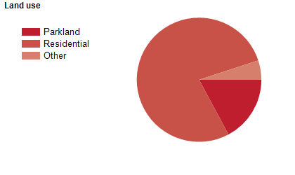
Land use
The Waverley Council area is predominantly residential, with significant commercial areas. The Council area encompasses a total land area of 9 square kilometres, including substantial foreshore areas and beaches.
Transport
The Waverley Council area is served by the Eastern Suburbs railway line.
Major features
- Major features of the Council area include the Bondi Junction Business District,
- Eastgate Bondi Junction Shopping Centre,
- Westfield Bondi Junction Shopping Centre,
- Bondi Beach,
- Bronte Beach,
- Tamarama Beach,
- Eastern Beaches Coastal Walk,
- Coastal Cliff Walk,
- War Memorial Hospital Waverley,
- Bondi Golf & Diggers Club,
- Bondi Pavilion Community Cultural Centre,
- Waverley Cemetery,
- Bondi Park,
- Bronte Park,
- Queens Park,
- Waverley Park and various baths.
Included areas
- The Waverley Council area includes the suburbs of Bondi,
- Bondi Beach,
- Bondi Junction,
- Bronte,
- Dover Heights,
- North Bondi,
- Queens Park,
- Rose Bay (part),
- Tamarama,
- Vaucluse (part) and Waverley.