City of Sydney
About the profile areas
The 2023 Estimated Resident Population for the City of Sydney is 231,086, with a population density of 8,660 persons per square km.
Location and boundaries
Sydney is the capital of New South Wales. The City of Sydney is bounded by Port Jackson in the north, the Woollahra Municipal Council area and Randwick City in the east, the Bayside Council area in the south, and the Inner West Council area in the west.
Traditional Owners
The original inhabitants of the Sydney area were the Gadigal band of the Eora Aboriginal tribe.
Name origin
Sydney was named by Captain Arthur Phillip after Viscount Sydney, Thomas Townshend, who was British Home Secretary at the time. It was originally known as Sydney Cove.
Important
|
Population231,086 2023 ABS ERP |
Land area26.68 square km |
Population density8,660 persons per square km |
Settlement history
European settlement dates from 1788 when the soldiers and convicts of the First Fleet dropped anchor at Sydney Cove. Sydney began its life as a penal colony, with free settlers arriving from 1793. Early industries included whaling, sealing and shipping of wool. After the crossing of the Blue Mountains in 1813, growth began to increase. In 1842, shortly after transportation of convicts to New South Wales was abolished, Sydney was declared a city. During the 1840s and 1850s the population grew rapidly, aided by the gold rush and many American and Chinese immigrants. Population and industrial growth continued during the early 1900s. Working class suburbs like Pyrmont, Glebe and Redfern became natural places for people to live from the 1930s, as housing was cheap and there was plenty of work in nearby factories. In the 1950s the western boundary of the City was characterised by port related functions, including warehousing, light industry and some worker’s housing. Significant growth took place during the 1950s and 1960s, with redevelopment of some of the older suburbs occurring from the 1970s. In more recent decades much of Sydney has undergone significant change and redevelopment. Factories, warehouses and old worker’s dwellings have been recycled or replaced with office buildings, hotels, public buildings and apartments. Major infrastructure and development projects reflect this transformation from an industrial nature to a mixed use residential and employment centre. Darling Harbour was remade in the late 1980s as a tourist and entertainment site. Since the 1990s the number of people living within the City has expanded dramatically, with the population increasing from about 104,000 in 1991 to about 182,000 in 2011. The population grew significantly between 1996 and 2011, in part facilitated by the Council's planning policies which encouraged residential development in the City.
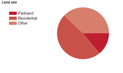
Land use
The City of Sydney is a mixed use area, with residential, commercial, industrial and institutional land use. The City encompasses a total land area of about 26 square kilometres.
Transport
The City of Sydney is served by the Bradfield Highway, the Cahill Expressway, the Eastern Distributor, the Western Distributor, Parramatta Road, several railway lines and many buses and ferries.
Major features
- Major features of the City include the Sydney CBD,
- Chinatown,
- Sydney Harbour,
- Darling Harbour,
- Circular Quay,
- Sydney Harbour Bridge,
- Sydney Opera House,
- Sydney Tower Eye & Skywalk,
- ICC Sydney (International Convention Centre),
- Sydney Observatory,
- Wild Life Sydney Zoo,
- Sea Life Sydney Aquarium,
- The Star (Casino,
- Hotel & Entertainment Centre),
- Powerhouse Museum,
- Sydney Cricket Ground,
- Allianz Stadium,
- The Rocks,
- The University of Sydney (Camperdown/Darlington,
- Burren Street and Mallett Street Campuses,
- Conservatorium of Music and Sydney Law School),
- University of Technology Sydney (City Campus),
- Sydney TAFE (Eora and Ultimo Colleges),
- The University of Notre Dame Australia (Broadway and Darlinghurst Campuses),
- The University of New South Wales (CBD and Paddington Campuses),
- Central Queensland University (Sydney Campus),
- University of Tasmania (Darlinghurst Campus),
- Western Sydney University (Sydney City Campus),
- Royal Prince Alfred Hospital,
- St Vincent’s Hospital,
- Sydney Hospital,
- Sydney Dental Hospital,
- Sydney Eye Hospital,
- Royal Botanic Gardens,
- The Domain,
- Hyde Park and numerous marinas,
- wharves,
- museums,
- theatres and parks.
Included areas
- The City of Sydney includes the suburbs of Alexandria,
- Annandale (part),
- Barangaroo,
- Beaconsfield,
- Camperdown (part),
- Centennial Park (part),
- Chippendale,
- Darlinghurst,
- Darlington,
- Dawes Point,
- Elizabeth Bay,
- Erskineville,
- Eveleigh,
- Forest Lodge,
- Glebe,
- Haymarket,
- Millers Point,
- Moore Park,
- Newtown (part),
- Paddington (part),
- Potts Point,
- Pyrmont,
- Redfern,
- Rosebery (part),
- Rushcutters Bay,
- St Peters (part),
- Surry Hills,
- Sydney,
- The Rocks,
- Ultimo,
- Waterloo,
- Woolloomooloo and Zetland.