North Sydney Council area
About the profile areas
The 2023 Estimated Resident Population for North Sydney Council area is 72,014, with a population density of 6,862 persons per square km.
Location and boundaries
The North Sydney Council area is located in Sydney's inner northern suburbs, about 3 kilometres from the Sydney GPO. The North Sydney Council area is bounded by Willoughby City and Long Bay in the north, the Mosman Council area in the east, Port Jackson in the south, and the Lane Cove Council area in the west.
Traditional Owners
The original inhabitants of the North Sydney Council area were the Cammeraygal and Wallumedegal Aboriginal clans.
Name origin
The North Sydney Council area is named for the area north of the Sydney CBD, which was named by Captain Arthur Phillip after Viscount Sydney, Thomas Townshend, who was British Home Secretary at the time.
Important
|
Population72,014 2023 ABS ERP |
Land area10.49 square km |
Population density6,862 persons per square km |
Settlement history
European settlement dates from 1805 when the first land grants were made, although development was slow due to the rugged terrain, limited access and limited agricultural potential. Land was used mainly for farming and orcharding, with some timber-getting and boat-building industries. Access was improved when ferry services began across Sydney Harbour in 1830. Land was subdivided and sold in the 1850s, with some growth in the 1870s and the 1880s. More significant growth occurred in the 1890s, spurred by the opening of the North Shore railway line (from St Leonards to Hornsby). There was some growth in the early 1900s. Considerable development took place from the 1930s, following the opening of the Sydney Harbour Bridge. The most significant development occurred in the post-war years, especially in the 1960s and 1970s when the North Sydney CBD experienced significant commercial and office development. Many flats and medium/high density housing were built from the 1960s. The population continued to increase from the 1990s, rising from about 50,000 in 1991 to over 67,000 in 2016.
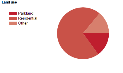
Land use
The North Sydney Council area is predominantly a residential area, but also has substantial commercial areas. Over two-thirds of housing is medium-density (units, townhouses, semi-detached dwellings and terrace houses). The Council area encompasses a total land area of about 11 square kilometres.
Transport
The North Sydney Council area is served by the Bradfield Highway, the Pacific Highway, the Warringah Freeway and the North Shore railway line.
Major features
- Major features of the Council area include the North Sydney CBD,
- Admiralty House,
- Kirribilli House,
- Luna Park,
- HMAS Waterhen,
- Cammeray Golf Course,
- North Sydney Olympic Pool,
- North Sydney Oval,
- Primrose Park,
- Waverton Park,
- North Sydney Circle Walk,
- TAFE NSW Northern Sydney Institute (Bradfield Senior College),
- The Northern Sydney Institute (Crows Nest Campus),
- Australian Catholic University (North Sydney - MacKillop Campus),
- The Mater Hospital,
- Coal Loader Centre for Sustainability and the Sydney Harbour Bridge.
Included areas
- The North Sydney Council area includes the suburbs of Cammeray,
- Cremorne,
- Cremorne Point,
- Crows Nest,
- Kirribilli,
- Kurraba Point,
- Lavender Bay,
- McMahons Point,
- Milsons Point,
- Neutral Bay,
- North Sydney,
- St Leonards (part),
- Waverton and Wollstonecraft.