City of Newcastle
About the profile areas
The 2023 Estimated Resident Population for the City of Newcastle is 174,294, with a population density of 932.9 persons per square km.
Location and boundaries
The City of Newcastle is located in the Hunter Region of New South Wales, about 160 kilometres north of Sydney. The City of Newcastle is bounded by Maitland City and the Port Stephens Council area in the north, the Pacific Ocean in the east, Lake Macquarie City in the south, and Cessnock City in the west.
Traditional Owners
The original inhabitants of the Newcastle area were the Awabakal and Worimi Aboriginal people.
Name origin
Newcastle was named after another coal port, Newcastle upon Tyne, in England.
Important
|
Population174,294 2023 ABS ERP |
Land area186.8 square km |
Population density932.9 persons per square km |
Settlement history
European settlement dates from 1801, although population was minimal, with the area used as a penal settlement from 1804 to 1823. Growth took place from the mid 1820s when the township of Newcastle grew as a free settlement. Land was used mainly for farming, with coal mining established in the 1830s. The town grew in the 1850s, aided by industrial growth, the subdivision of land and the extension of the railway line. Newcastle rapidly became a major coal producer, port and railhead. Many mining villages were established. Growth took place in the 1870s and 1880s, with the population growing to about 50,000 by the start of the 1900s. Expansion continued in the early 1900s, aided by the establishment of the BHP steelworks in 1915. The most significant residential development occurred in the post-war years, aided by industrial growth from the 1940s and revitalisation in the 1950s and 1960s. During the 1970s and the 1980s the population of the City declined, largely due to economic downturns which affected heavy industry, with the population falling from about 146,000 in 1971 to 129,000 in 1986. From the late 1980s the population increased, growing from about 131,000 in 1991 to 148,000 in 2011, aided by urban renewal.
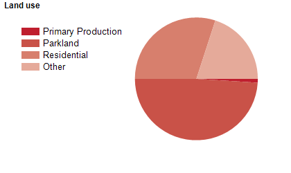
Land use
The City of Newcastle is a residential and industrial area, with rural areas in the north-west, and several commercial areas. The local government area encompasses a total land area of nearly 200 square kilometres. The greater Newcastle area is the economic, administrative and cultural centre of the Hunter Region. Shipping is a major industry, with Newcastle being one of the world's largest coal exporting ports.
Transport
The City of Newcastle is served by the Sydney Newcastle Freeway, the Pacific Highway, the New England Highway, Newcastle Airport and the Newcastle & North Coast railway line.
Major features
- Major features of the City include the Newcastle CBD,
- The Port of Newcastle,
- Fort Scratchley,
- Maritime Centre Newcastle,
- Newcastle Museum,
- Newcastle Art Gallery,
- The University of Newcastle,
- TAFE NSW Hunter Institute,
- John Hunter Hospital,
- Hunter Stadium,
- Westfield Kotara Shopping Centre,
- King Edward Park,
- Blackbutt Reserve,
- Hexham Swamp Nature Reserve,
- Kooragang Wetlands,
- Glenrock State Conservation Area,
- Hunter Wetlands Centre,
- The Great North Walk,
- Bathers Way Coastal Walk,
- The Hunter River and numerous beaches.
Included areas
- The City of Newcastle encompasses the suburbs and localities of Adamstown,
- Adamstown Heights (part),
- Bar Beach,
- Beresfield,
- Birmingham Gardens,
- Black Hill (part),
- Broadmeadow,
- Callaghan,
- Carrington,
- Cooks Hill,
- Elermore Vale,
- Fletcher,
- Fullerton Cove,
- Georgetown,
- Hamilton,
- Hamilton East,
- Hamilton North,
- Hamilton South,
- Hexham,
- Islington,
- Jesmond,
- Kooragang,
- Kotara,
- Lambton,
- Lenaghan,
- Maryland,
- Maryville,
- Mayfield,
- Mayfield East,
- Mayfield North,
- Mayfield West,
- Merewether,
- Merewether Heights,
- Minmi,
- New Lambton,
- New Lambton Heights (part),
- Newcastle,
- Newcastle East,
- Newcastle West,
- North Lambton,
- Rankin Park (part),
- Sandgate,
- Shortland,
- Stockton,
- Tarro,
- The Hill,
- The Junction,
- Tighes Hill,
- Wallsend,
- Warabrook,
- Waratah,
- Waratah West and Wickham.