Nambucca Valley
About the profile areas
The 2023 Estimated Resident Population for the Nambucca Valley is 20,774, with a population density of 13.92 persons per square km.
Location and boundaries
The Nambucca Valley Council lies 493kms north of Sydney and 431kms south of Brisbane, centrally located in northern NSW between Port Macquarie and Coffs Harbour. The Nambucca Valley Council is bounded by Kempsey Shire to the south and west and Bellingen Shire to the north.
Traditional Owners
The original inhabitants of the Nambucca area were the Gumbaynggir peoples.
Name origin
The place name Nambucca is thought to be derived from the Gumbaynggir word Nyambaga. People from the south side of the Nambucca River were the Ngambaa and the word for knee is baga baga. To explain, in the dreaming or creation time the people of the land were giants. Visitors from the north came upon a giant Ngambaa man and they speared him. As the giant fell to the ground, his knee made an impression in the ground which caused a bend in the river. The area was then named Ngambaga after the Nyam (people of the south) and baga baga (referring to the knee-shaped bend in the river).
Important
|
Population20,774 2023 ABS ERP |
Land area1,493 square km |
Population density13.92 persons per square km |
Settlement history
The first Europeans visited Nambucca in 1818. Cedar was gathered and shipped from the area from 1842 but it wasn’t until 1867 when the first settler built a shelter on the northern headland of Nambucca and begun a ferry service across the Nambucca River in support of the local timbergetters. Sawmills were built in 1870 and the town was surveyed in 1874 although the first lots were not sold until 1879. The towns first hotel and shop were opened in 1884 and the next year Nambucca Village was proclaimed. Local Government was established some three decades later in 1915. The arrival of rail in 1923 changed the face of industry and agriculture grow, as did mining (molybdenite, antimony and pyrites) in the years between the great wars.
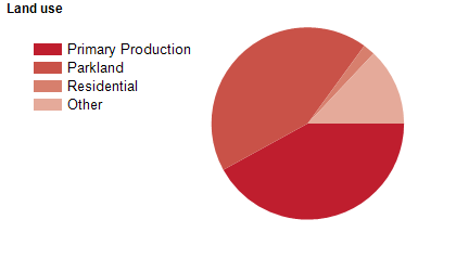
Land use
The primary industries of agriculture, forestry and fishing dominate land use. Agribusinesses are well established including blueberries, macadamias, bananas, avocados, vegetables, and beef cattle. Tourism is supported by and rising growth in niche manufacturing and engineering are supported by competitive land prices.
Transport
The Nambucca Vally area is served by the Pacific Highway and the NSW TrainLink.
Major features
- Nambucca Valley includes many small towns,
- villages and localities including Nambucca Heads,
- Macksville,
- Bowraville,
- Valla Beach,
- Scotts Head and Hyland Park. Jacks Ridge Mountain Bike Park,
- Gaagal Wanggaang (South Beach) National Park,
- Dunggir National Park,
- The Kosekai Lookout,
- Nambucca Heads Beaches and estuary are local features. Cultural attractions include the Frank Partridge VC Military Museum,
- The Bowraville Folk Museum,
- The Mary Boulton Pioneer Cottage and Museum,
- The Stringer Art Gallery,
- Nambucca Headland Museum,
- and the Nambucca Heads Foreshore Public Art walk.
Included areas
- Nambucca Valley includes the localities of Allgomera,
- Argents Hill,
- Bakers Creek,
- Bowraville,
- Buckra Bendinni,
- Burrapine,
- Congarinni,
- Congarinni North,
- Eungai Creek,
- Eungai Rail,
- Girralong,
- Gumma,
- Hyland Park,
- Macksville,
- Missabotti,
- Nambucca Heads,
- Newee Creek,
- North Macksville,
- Scotts Head,
- South Arm,
- Talarm,
- Tamban,
- Taylors Arm,
- Tewinga,
- Thumb Creek,
- Upper Taylors Arm,
- Utungun,
- Valla Beach,
- Warrell Creek,
- Way Way,
- Wirrimbi and Yarranbella. It also includes portions of Valla,
- Kennaicle Creek and Spicketts Creek.