Ku-ring-gai Council area
About the profile areas
The 2023 Estimated Resident Population for Ku-ring-gai Council area is 126,983, with a population density of 1,486 persons per square km.
Location and boundaries
The Ku-ring-gai Council area is located in Sydney's northern suburbs, about 16 kilometres from the Sydney GPO. The Ku-ring-gai Council area is bounded by the Northern Beaches Council area in the east, Willoughby City and the City of Ryde in the south, and Hornsby Shire in the west. The Ku-ring-gai Council area boundaries are the Cockle and Cowan Creeks in the north, Middle Harbour Creek and Middle Harbour in the east, Boundary Street, Blue Gum Creek and the Lane Cove River in the south, and Coups Creek and the Sydney-Newcastle Freeway in the west.
Traditional Owners
The original inhabitants of the Ku-ring-gai Council area were the Kuringgai Aboriginal people.
Name origin
The Ku-ring-gai Council area is named after the Kuringgai Aboriginal group who once inhabited the area, meaning 'belonging to the Aborigines'.
Important
|
Population126,983 2023 ABS ERP |
Land area85.44 square km |
Population density1,486 persons per square km |
Settlement history
European settlement in the Ku-ring-gai area dates from 1814 when land was settled next to the Lane Cove River. Land was used mainly for timber-getting and saw-milling, with many farms and orchards established from the 1840s, and market gardens from the 1870s. Residential subdivision and growth occurred after the opening of the North Shore railway line in 1890. Some growth took place in the 1920s and 1930s, spurred by land subdivision and increased access brought about by the opening of the Sydney Harbour Bridge. The area remained semi-rural until the 1940s, with a population of 40,000 in 1947. The most significant development took place during the post-war years. Substantial growth occurred between 1950 and 1980, when the population doubled from 50,000 to 100,000, with the most rapid growth during the 1950s and 1960s. During the 1970s population growth began to slow down, with the population being relatively stable during the 1980s. The population fluctuated slightly between 1991 and 2006, between 99,000 and 100,000. Growth took place from 2006, with the population increasing to nearly 117,000 in 2016. Much of the recent growth has been in areas where urban consolidation (medium and high density housing) has occurred, such as Gordon, Killara, St Ives, Turramurra and Wahroonga, particularly along the Pacific Highway and near the railway stations.
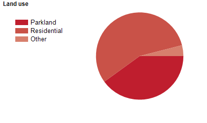
Land use
The Ku-ring-gai Council area is predominantly residential, with significant areas of parkland and bushland. The Council area encompasses a total land area of 84 square kilometres, of which a large proportion is National Park, public park, bushland or reserves. There is very little commercial or industrial land use.
Transport
The Ku-ring-gai Council area is served by the Pacific Highway, the Sydney-Newcastle Freeway and the North Shore railway line.
Major features
- Major features of the Council area include Garigal National Park,
- Ku-ring-gai Chase National Park,
- Lane Cove National Park,
- CSIRO Lindfield,
- St Ives Village Shopping Centre,
- Sydney Adventist Hospital (The SAN),
- Lady Davidson Private Hospital,
- Echo Point Park,
- Ku-ring-gai Bicentennial Park,
- Ku-ring-gai Wildflower Garden,
- Lindfield Soldiers Memorial Park,
- St Ives Showground,
- Swain Gardens,
- Wahroonga Park,
- Ku-ring-gai Fitness and Aquatic Centre,
- Marian Street Theatre,
- Ku-ring-gai Art Centre and the Great North Walk.
Included areas
- The Ku-ring-gai Council area includes the suburbs of East Killara,
- East Lindfield,
- Gordon,
- Killara,
- Lindfield,
- North Turramurra,
- North Wahroonga,
- Pymble,
- Roseville (part),
- Roseville Chase,
- South Turramurra,
- St Ives,
- St Ives Chase,
- Turramurra,
- Wahroonga (part),
- Warrawee and West Pymble.