Hobsons Bay City
About the profile areas
The 2023 Estimated Resident Population for Hobsons Bay City is 93,738, with a population density of 1,460 persons per square km.
Location and boundaries
Hobsons Bay City is located in Melbourne's south-western suburbs, between 5 and 20 kilometres from the Melbourne CBD. Hobsons Bay City is bounded by the City of Brimbank and the City of Maribyrnong in the north, the Yarra River and the City of Melbourne in the east, Port Phillip Bay in the south, and the City of Wyndham in the west. Hobson Bay City's boundaries are the Princes Freeway, the Princes Highway, Cemetery Road, the West Gate Freeway, Stony Creek, Hyde Street and Francis Street in the north, the Yarra River and Hobsons Bay in the east, Port Phillip Bay, Skeleton Creek, a line between Crystal Court and South Terrace, a line between Fawkner Way and Evening Close, a line between Tournament Drive and George Benjamin Court and Dunnings Road in the south, and a line between St Anthonys Court and Machar Drive, the Princes Freeway, Point Cook Road, Maher Road, the eastern side of RAAF Williams Laverton Base and the Old Geelong Road in the west.
Traditional Owners
The original inhabitants of Hobsons Bay City were the Yalukit-William Aboriginal people.
Name origin
Hobsons Bay City is named after William Hobson, Commander of HMAS Rattlesnake, who also surveyed Port Phillip and Hobsons Bays.
Important
|
Population93,738 2023 ABS ERP |
Land area64.20 square km |
Population density1,460 persons per square km |
Settlement history
European settlement dates from 1837, with the establishment of a port at Williamstown and the expansion of pastoralists into the Altona area. Williamstown developed as a major maritime centre during the 1800s, aided by the arrival of railways from Melbourne in 1859. Growth continued through to the early 1900s, aided by the establishment of the RAAF Williams Base in 1926. Significant residential development occurred during the immediate post-war years, accompanied by industrial growth. The population of the City generally increased from the 1990s, with the most rapid growth in recent years. During this time there has been considerable growth in the south-west, in the suburbs of Altona Meadows and Seabrook. There have also been new residential developments in the established suburbs of Williamstown and Newport, as a result of redevelopment of former industrial and surplus government land (the Rifle Range and Williamstown Junction developments).
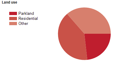
Land use
Hobsons Bay City is a residential and industrial area. The City encompasses a total land area of about 64 square kilometres.
Transport
Hobsons Bay City is served by the West Gate Freeway, the Princes Freeway, the Princes Highway, the Werribee and Williamstown railway lines and various ferries.
Major features
- Major features of Hobsons Bay City include Scienceworks,
- The Williamstown Business District,
- Altona Gate Shopping Centre,
- Central Square Shopping Centre,
- The Pier Street shopping strip in Altona,
- Williamstown port and marina areas,
- Newport Power Station,
- Newport Rail Workshops,
- Hobsons Bay Coastal Park,
- Cheetham Wetlands,
- Jawbone Flora and Fauna Reserve,
- Newport Lakes Park,
- Williamstown Botanic Gardens,
- Point Gellibrand Coastal Heritage Park,
- Altona Miniature Railway,
- Seaworks Maritime Precinct,
- Cherry Lake and several beaches.
Included areas
- Hobsons Bay City includes the suburbs of Altona,
- Altona Meadows,
- Altona North,
- Brooklyn (part),
- Laverton (part),
- Newport,
- Seabrook,
- Seaholme,
- Spotswood,
- South Kingsville,
- Williamstown and Williamstown North. Note: The Altona Industrial area (encompassing parts of the suburbs of Altona and Altona North) has been excluded from the community profile,
- as there is no population residing in this area.