City of Glen Eira
About the profile areas
The 2023 Estimated Resident Population for the City of Glen Eira is 156,837, with a population density of 4,056 persons per square km.
Location and boundaries
The City of Glen Eira is located in Melbourne's south-eastern suburbs, about 10 kilometres from the Melbourne CBD. The City of Glen Eira is bounded by the City of Stonnington in the north, the City of Monash in the east, the City of Kingston in the south, and the City of Bayside and the City of Port Phillip in the west. The City of Glen Eira's boundaries are Dandenong Road in the north, Poath Road, North Road and Warrigal Road in the east, South Road in the south, and the Nepean Highway, Thomas Street, North Road, Hotham Street, Inkerman Street and Orrong Road in the west.
Traditional Owners
The original inhabitants of the City of Glen Eira were the Wurundjeri Aboriginal people.
Name origin
The City of Glen Eira is named from two local landmarks - Glen Eira Road and Glen Eira Mansion.
Important
|
Population156,837 2023 ABS ERP |
Land area38.67 square km |
Population density4,056 persons per square km |
Settlement history
European settlement dates from the 1840s. Land was swampy, and used mainly for farming in the north, and market gardening in the south. Residential growth took place in the 1880s, with expansion continuing during the early 1900s and the interwar period. Significant development occurred from the post-war years through to the 1960s. The population gradually declined during the 1970s and 1980s, and then gradually increased from the 1990s.
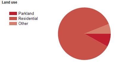
Land use
The City of Glen Eira is an established residential area that is continuing to attract housing development. The City of Glen Eira contains a diversity of housing, ranging from 1880s mansions in suburbs such as Caulfield North and St Kilda East, to post-war growth areas such as Bentleigh East. The City encompasses a total land area of about 38 square kilometres.
Transport
The City of Glen Eira is served by the Nepean Highway, Dandenong Road, North Road and the Frankston/Stony Point, Cranbourne/Pakenham and Sandringham railway lines.
Major features
- Major features of the City of Glen Eira include Caulfield Racecourse,
- Monash University (Caulfield Campus),
- Rippon Lea historic mansion,
- Labassa historic mansion,
- Monash Medical Centre (Moorabbin Hospital),
- Caulfield Hospital,
- Yarra Yarra Golf Club,
- Glen Eira Sports and Aquatic Centre,
- Caulfield Park,
- Princes Park,
- Bailey Reserve,
- Centenary Park,
- Duncan MacKinnon Reserve,
- McKinnon Reserve and various shopping strips along several of the main roads.
Included areas
- The City of Glen Eira includes the suburbs of Bentleigh,
- Bentleigh East,
- Carnegie,
- Caulfield,
- Caulfield East,
- Caulfield North,
- Caulfield South,
- Elsternwick,
- Gardenvale,
- Glen Huntly,
- McKinnon,
- Murrumbeena and Ormond,
- and parts of the suburbs of Brighton East and St Kilda East.