Byron Shire
About the profile areas
The 2023 Estimated Resident Population for Byron Shire is 37,126, with a population density of 65.52 persons per square km.
Location and boundaries
Byron Shire is located on the Far North Coast of New South Wales, about 800 kilometres north of the Sydney CBD and 200 kilometres south of the Brisbane CBD. Byron Shire is bounded by Tweed Shire in the north, the Coral Sea in the east, Ballina Shire in the south, and Lismore City in the west.
Traditional Owners
The original inhabitants of Byron Shire were the Bundjalung (Arakwal) Aboriginal people.
Name origin
Byron Shire is named after Cape Byron, which was named by Captain Cook in 1770 in honour of British explorer John Byron.
Important
|
Population37,126 2023 ABS ERP |
Land area566.6 square km |
Population density65.52 persons per square km |
Settlement history
European settlement dates from the late 1840s, with land used mainly for timber-getting and farming. Growth took place during the late 1800s and early 1900s, spurred by port activities, the opening of the railway line, and growth in the dairy industry. The population of the Shire grew from under 8,000 in 1911 to about 10,000 in 1921. The population fluctuated in the post-war years, with steady population growth during the 1970s and 1980s, aided by tourism. The Shire’s population increased from about 11,000 in 1976 to over 15,000 in 1981, and then to over 18,000 in 1986. Growth continued from the 1990s, with the population rising to nearly 23,000 in 1991, to about 29,000 in 2001, and then to about 30,000 in 2011.
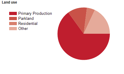
Land use
Byron Shire encompasses rural areas, national parks, residential and rural-residential areas, and some commercial and industrial land use. The urban areas are concentrated along the coast, at Byron Bay, Brunswick Heads, New Brighton, Ocean Shores, South Golden Beach and Suffolk Park. Rural-residential areas are located in the hinterland, including the small townships of Bangalow, Ewingsdale and Mullumbimby. The Shire encompasses a total land area of about 560 square kilometres. Rural land is used largely for agriculture, particularly dairy farming, and sugar cane, fruit, nut and coffee growing. Tourism is also an important industry.
Transport
Byron Shire is served by the Pacific Highway.
Major features
- Major features of the Shire include Arakwal National Park,
- Goonengerry National Park,
- Mount Jerusalem National Park,
- Nightcap National Park,
- Andrew Johnston Big Scrub Nature Reserve,
- Billinudgel Nature Reserve,
- Broken Head Nature Reserve,
- Brunswick Heads Nature Reserve,
- Cumbebin Swamp Nature Reserve,
- Hayters Hill Nature Reserve,
- Inner Pocket Nature Reserve,
- Marshalls Creek Nature Reserve,
- Snows Gully Nature Reserve,
- Tyagarah Nature Reserve,
- Cape Byron State Conservation Area,
- Whian Whian State Conservation Area,
- Cape Byron Marine Park,
- Cape Byron Lighthouse,
- Minyon Falls,
- numerous beaches,
- Byron Regional Sports and Cultural Complex and the Brunswick River.
Included areas
- Byron Shire includes the suburbs,
- townships and localities of Bangalow,
- Billinudgel,
- Binna Burra,
- Booyong (part),
- Broken Head (part),
- Brunswick Heads,
- Byron Bay,
- Clunes (part),
- Coopers Shoot,
- Coorabell,
- Eureka,
- Ewingsdale,
- Federal,
- Goonengerry,
- Hayters Hill,
- Huonbrook,
- Koonyum Range,
- Main Arm,
- McLeods Shoot,
- Middle Pocket,
- Montecollum,
- Mullumbimby,
- Mullumbimby Creek,
- Myocum,
- Nashua,
- New Brighton,
- Newrybar (part),
- Nightcap (part),
- Ocean Shores,
- Palmwoods,
- Possum Creek,
- Skinners Shoot,
- South Golden Beach,
- Suffolk Park,
- Talofa,
- The Pocket,
- Tyagarah,
- Upper Coopers Creek,
- Upper Main Arm,
- Upper Wilsons Creek,
- Wanganui,
- Whian Whian (part),
- Wilsons Creek,
- Wooyung (part) and Yelgun.