Yass Valley Council area
About the profile areas
The 2023 Estimated Resident Population for the Yass Valley Council area is 17,477, with a population density of 4.37 persons per square km.
Location and boundaries
The Yass Valley Council area is located in south-eastern New South Wales, about 280 kilometres south-west of the Sydney CBD, and 60 kilometres north-west of the Canberra CBD. The Yass Valley Council area is bounded by the Hilltops Council area and Upper Lachlan Shire in the north, the Queanbeyan-Palerang Regional Council area in the east, the Australian Capital Territory and the Snowy Valleys Council area in the south, and the Cootamundra-Gundagai Regional Council area and the Hilltops Council area in the west.
Traditional Owners
The original inhabitants of the Yass Valley area were the Ngunnawal and Wirarjuri Aboriginal people.
Name origin
Yass Valley is thought to be named from the Aboriginal word "yarrh" meaning "running water".
Important
|
Population17,477 2023 ABS ERP |
Land area3,995 square km |
Population density4.37 persons per square km |
Settlement history
European settlement dates from the 1820s, following exploration by Hume and Hovell. Land was used mainly for sheep grazing, with the village of Yass established on the southern bank of the Yass River in the 1830s. Gradual growth took place during the mid 1800s. More substantial growth occurred during the late 1800s, aided by the opening of the railway line in 1876. The population increased gradually during the 1980s. Growth continued from the 1990s, with the population rising from about 10,000 in 1991 to nearly 15,000 in 2011.
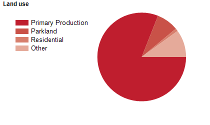
Land use
The Yass Valley Council area is predominantly rural, with a township at Yass and villages at Binalong, Bookham, Bowning, Gundaroo, Murrumbateman, Sutton and Wee Jasper. Rural land is used largely for agriculture, particularly sheep grazing. Tourism and viticulture are also important industries. The Council area encompasses a total land area of about 4,000 square kilometres.
Transport
The Yass Valley Council area is served by the Hume Highway, the Barton Highway, the Federal Highway and the main southern railway line.
Major features
- Major features of the Council area include Burrinjuck (Yass) Dam,
- The Murrumbidgee River,
- The Yass River,
- Brindabella National Park,
- Burrinjuck Holiday and Recreation Park,
- Black Andrew Nature Reserve,
- Burrinjuck Nature Reserve,
- Hattons Corner Nature Reserve,
- Mundoonen Nature Reserve,
- Oak Creek Nature Reserve,
- Wee Jasper Nature Reserve,
- Brindabella State Conservation Area,
- Bondo State Forest,
- Wee Jasper State Forest,
- Hume and Hovell Walking Track,
- Yass and District Museum,
- Yass Railway Museum,
- Binalong Motor Museum,
- TAFE NSW Illawarra Institute (Yass Campus),
- Walker Park,
- Victoria Park,
- Joe O’Connor Park,
- Yass Showground (including Yass Indoor Stadium),
- Carey’s Cave,
- Cooma Cottage and numerous wineries.
Included areas
- The Yass Valley Council area includes the localities of Bango,
- Bellmount Forest (part),
- Binalong,
- Boambolo,
- Bookham,
- Bowning,
- Brindabella (part),
- Burrinjuck,
- Bywong (part),
- Cavan,
- Collector (part),
- Good Hope,
- Gundaroo,
- Jeir,
- Kangiara,
- Lake George (part),
- Laverstock,
- Lerida (part),
- Manton,
- Marchmont,
- Mullion,
- Murrumbateman,
- Nanima,
- Narrangullen,
- Springrange,
- Sutton (part),
- Uriarra (part),
- Wallaroo,
- Wee Jasper,
- Woolgarlo,
- Yass and Yass River.