City of Wodonga
About the profile areas
The 2023 Estimated Resident Population for the City of Wodonga is 44,276, with a population density of 102.3 persons per square km.
Location and boundaries
The City of Wodonga is located in north-eastern Victoria, on the New South Wales border, about 300 kilometres north-east of the Melbourne CBD. The City of Wodonga is bounded by the Murray River in the north, Towong Shire in the east, and Indigo Shire in the south and west.
Traditional Owners
The original inhabitants of the City of Wodonga were the Wiradjuri Aboriginal people.
Name origin
The City of Wodonga is named from an Aboriginal word meaning 'bulrushes'. It was originally known as Belvoir.
Important
|
Population44,276 2023 ABS ERP |
Land area432.6 square km |
Population density102.3 persons per square km |
Settlement history
European settlement dates from 1836, with land used mainly for grazing and farming. Growth was minimal until the 1850s when a town was established and Wodonga became an important river port for the Ovens goldfield. More substantial growth took place from the 1870s, aided by the construction of the railway line from Melbourne and the opening of pastoral runs for selection. Wodonga became a major stock selling centre, with a population of about 900 in 1901, increasing to over 3,000 in 1947. Significant development occurred in the post-war years, with the population more than doubling in the 1950s to reach nearly 8,000 in 1961. The most substantial development took place during the 1970s and 1980s, aided by designation as a national growth centre and the Albury Wodonga Development Corporation. The population doubled between the 1970s and the 1990s. Growth continued from the 1990s, with the majority of recent growth in the western and southern parts of Wodonga.
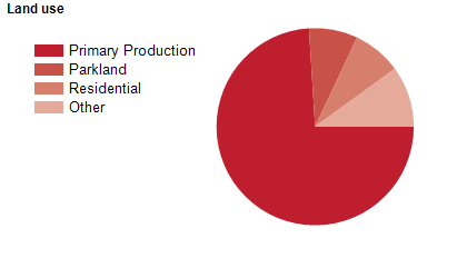
Land use
The City of Wodonga includes the main urban centre of Wodonga, as well as significant rural hinterland and substantial industrial areas. The City encompasses a total land area of 434 square kilometres. The majority of the population live in the urban areas. Rural land is used mainly for agriculture, including grazing and dairy farming.
Transport
The City of Wodonga is served by the Hume Freeway, the Kiewa Valley Highway, the Murray Valley Highway and the Sydney to Melbourne railway line.
Major features
- Major features of the City of Wodonga include Lake Hume,
- The Murray River,
- Wodonga Plaza (shopping centre),
- Birallee Village Shopping Centre,
- White Box Rise Shopping Centre,
- Gateway Village,
- La Trobe University (Albury-Wodonga Campus),
- Wodonga TAFE,
- Wodonga Golf Club,
- Gaza Ridge Barracks,
- The Army Museum Bandiana,
- Albury Wodonga Health (Wodonga Campus),
- WAVES (Wodonga Aquatic Venue & Exercise Space),
- Wodonga Sports and Leisure Centre,
- Bonegilla Migrant Experience,
- Sumsion Gardens and Baranduda Regional Park.
Included areas
- The City of Wodonga includes the suburbs and localities of Bandiana,
- Baranduda,
- Barnawartha North,
- Bonegilla,
- Castle Creek,
- Ebden,
- Gateway Island,
- Huon Creek,
- Killara,
- Leneva,
- Staghorn Flat (part),
- West Wodonga and Wodonga.