City of Whitehorse
About the profile areas
The 2023 Estimated Resident Population for the City of Whitehorse is 178,639, with a population density of 2,781 persons per square km.
Location and boundaries
The City of Whitehorse is located in Melbourne's middle-eastern suburbs, between 12 and 22 kilometres east of the Melbourne CBD. The City of Whitehorse is bounded by the Manningham City Council area in the north, the City of Maroondah and the City of Knox in the east, the City of Monash in the south, and the City of Boroondara in the west. The City of Whitehorse's boundaries are Koonung Creek, Worrell Street, Mitcham Road, Chippewa Avenue and Mullum Mullum Creek in the north, Dampier Grove, Heatherdale Road and Dandenong Creek in the east, Highbury Road in the south, and Warrigal Road, Alexandra Crescent, Windsor Crescent, Wilson Street, York Street, Barloa Road, Carlyle Street, Carrick Street, Kinsale Crescent, Kerry Parade, Evelina Street, Winfield Road and Sweyn Street in the west.
Traditional Owners
The original inhabitants of the City of Whitehorse were the Wurundjeri Aboriginal people.
Name origin
The City of Whitehorse is named after Whitehorse Road , which was named after the White Horse Inn, a tavern located in Box Hill in the late 1800s.
Important
|
Population178,639 2023 ABS ERP |
Land area64.24 square km |
Population density2,781 persons per square km |
Settlement history
European settlement dates from the 1840s. Population was minimal until the 1880s, following the construction of the Lilydale/Belgrave railway line. Early development was focussed on the railway line, with development spreading out to the north and south, particularly in the post-war period. The most significant development occurred during the interwar and post-war periods. The population increased gradually from the mid 1990s.
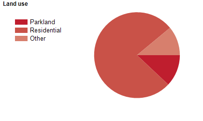
Land use
The City of Whitehorse is a predominantly residential area, but also has substantial commercial areas, and some industrial land use. The City encompasses a total land area of about 64 square kilometres.
Transport
The City of Whitehorse is served by the Eastern Freeway, Burwood Highway, Whitehorse Road, the Box Hill and Vermont South tram routes and the Belgrave and Lilydale railway lines.
Major features
- Major features of the City of Whitehorse include Deakin University (Melbourne Burwood Campus),
- Box Hill Institute of TAFE (Box Hill Campus),
- Box Hill Hospital,
- Box Hill Town Hall,
- Whitehorse Centre,
- Box Hill Community Arts Centre,
- Schwerkolt Cottage,
- Tally Ho Business Park,
- Box Hill Central Shopping Centre,
- The Whitehorse Road bulky goods shopping area,
- Brand Smart Premium Outlet Centre,
- Burwood One Shopping Centre,
- Forest Hill Chase Shopping Centre,
- Blackburn Lake Sanctuary,
- Aqualink Box Hill,
- Aqualink Nunawading,
- Wattle Park and the Box Hill transport interchange.
Included areas
- The City of Whitehorse includes the suburbs of Balwyn North (part),
- Blackburn,
- Blackburn North,
- Blackburn South,
- Box Hill,
- Box Hill North,
- Box Hill South,
- Burwood (part),
- Burwood East,
- Forest Hill,
- Mitcham,
- Mont Albert (part),
- Mont Albert North,
- Nunawading (part),
- Surrey Hills (part),
- Vermont (part) and Vermont South.