West Tamar Council area
About the profile areas
The 2023 Estimated Resident Population for West Tamar Council area is 26,039, with a population density of 37.73 persons per square km.
Location and boundaries
The West Tamar Council area is located in northern Tasmania, a few kilometres north-west of the Launceston CBD. The West Tamar Council area is bounded by Bass Strait in the north, the Tamar River in the east, the City of Launceston in the south-east, the Meander Valley Council area in the south, and the Latrobe Council area in the west.
Traditional Owners
The original inhabitants of the West Tamar area were the Leterremairrener and Pangerninghe Aboriginal people.
Name origin
West Tamar Council is named to describe the area to the west of the Tamar River.
Important
|
Population26,039 2023 ABS ERP |
Land area690.2 square km |
Population density37.73 persons per square km |
Settlement history
European settlement dates from 1804, when the first land grants were made. Population was minimal until the 1850s, with land used mainly for grazing, farming, timber-getting and ship building. Growth took place from the late 1870s into the 1910s, spurred by gold mining in Beaconsfield and orcharding. Gradual expansion took place from the post-war years, particularly from the 1960s. Growth continued from the 1980s, with the population rising from less than 14,000 in 1981 to about 17,000 in 1991, and then continuing to rise to nearly 23,000 in 2016.
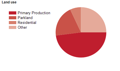
Land use
The West Tamar Council area includes rural areas and growing urban areas in numerous townships and villages, particularly areas in the south, closest to Launceston. Rural land is used mainly for agriculture (particularly fruit growing), aquaculture and viticulture, with some gold mining. Tourism is also an important industry. The Council area encompasses a total land area of about 690 square kilometres.
Transport
The West Tamar Council area is served by the Batman Highway and the West Tamar Highway.
Major features
- Major features of the Council area include the Tamar River,
- Narawntapu National Park,
- Tamar Island Wetlands,
- Holwell Gorge,
- Notley Fern Gorge,
- Trevallyn Nature Recreation Area,
- Trevallyn Dam,
- Lake Trevallyn,
- Trevallyn Power Station,
- Beaconsfield Mine and Heritage Centre,
- Platypus House,
- Seahorse World,
- Tasmania Zoo,
- Glengarry Bush Maze and Tearooms,
- Lavender House - The Perfumery,
- Grindelwald Swiss Village,
- York Town Historic Settlement Site,
- Australian Maritime College (Beauty Point Campus) and numerous wineries and vineyards.
Included areas
- The West Tamar Council area includes the localities of Badger Head,
- Beaconsfield (part),
- Beauty Point,
- Birralee (part),
- Blackwall,
- Bridgenorth (part),
- Clarence Point,
- Deviot,
- Exeter,
- Flowery Gully,
- Frankford (part),
- Glengarry,
- Gravelly Beach,
- Greens Beach,
- Grindelwald,
- Holwell (part),
- Kayena,
- Kelso,
- Lanena,
- Legana,
- Loira,
- Notley Hills,
- Parkham (part),
- Riverside (part),
- Robigana,
- Rosevale (part),
- Rosevears,
- Rowella,
- Selbourne (part),
- Sidmouth,
- Swan Point,
- Trevallyn (part),
- Winkleigh and York Town (part).