Wagga Wagga City
About the profile areas
The 2023 Estimated Resident Population for Wagga Wagga City is 68,716, with a population density of 14.24 persons per square km.
Location and boundaries
Wagga Wagga City is located in the Riverina region of southern New South Wales, about 450 kilometres south-west of the Sydney CBD and 460 kilometres north of the Melbourne CBD. Wagga Wagga City is bounded by Coolamon Shire and Junee Shire in the north, the Cootamundra-Gundagai Regional Council area and Snowy Valleys Council area in the east, Greater Hume Shire and Lockhart Shire in the south, and Narrandera Shire in the west.
Traditional Owners
The original inhabitants and custodians of the Wagga Wagga area were the Wiradjuri Aboriginal people.
Name origin
Wagga Wagga is named from an Aboriginal word meaning "the place where crows assemble in large numbers".
Important
|
Population68,716 2023 ABS ERP |
Land area4,825 square km |
Population density14.24 persons per square km |
Settlement history
European settlement dates from the early 1830s, when land was used for cattle stations. The township of Wagga Wagga was established in the 1840s. Population was minimal until the late 1870s, spurred by the construction of the railway line. Many small towns and villages were established along the railway line, with land used mainly for dairy farming, sheep grazing, wheat growing, fruit growing and wineries. The population grew during the late 1800s and early 1900s, rising from about 4,000 in 1881 to nearly 12,000 in 1933. Significant development occurred during the post-war years, with new suburbs developed to the south of the city, including returned soldier settlements. Rapid growth took place during the 1960s and 1970s, with the population increasing from about 15,000 in 1947 to 30,000 in 1971. Growth continued from the 1970s, with the population rising to about 40,000 in 1981 and then to 55,000 in 1996. The population was relatively stable between 1996 and 2001, and then increased to about 60,000 in 2011. Most of the recent growth has been in Glenfield Park and areas of South Wagga Wagga (such as Bourkelands and Tatton).
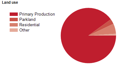
Land use
Wagga Wagga City constitutes both rural and urban areas, with some commercial, industrial and military areas. The City encompasses a total land area of 4,886 square kilometres. Most of the population is located in the urban areas. The largest centre is central Wagga Wagga, followed by Kooringal and Lake Albert. Most residential growth is on the higher ground to the south of the city centre, with the only residential areas north of the Murrumbidgee River being North Wagga Wagga and Estella. Rural land is used mainly for wheat-growing, dairy farming, mixed farming and sheep grazing.
Nestled on the banks of the magnificent Murrumbidgee River in Southern NSW, Wagga Wagga is a dynamic and cosmopolitan regional city. With close to 60,000 residents and thriving business, sports and arts communities, Wagga Wagga offers a temperate climate, diverse calendar of events, rich cultural heritage and wealth of fantastic attractions making it an ideal lifestyle destination for residents and visitors all-year-round.
Transport
Wagga Wagga City is served by the Hume Highway, the Olympic Highway, the Sturt Highway and the Melbourne-Sydney (main southern) railway line.
Major features
- Major features of the City include the Murrumbidgee River,
- Charles Sturt University (Wagga Wagga Main and South Campuses),
- TAFE NSW Riverina Institute (Wagga Wagga Campus and Primary Industries Centre),
- Kapooka Army Recruit Training Centre,
- RAAF Base Wagga (Forest Hill),
- Wagga Wagga City Council Civic Centre,
- Wagga Wagga Town Centre,
- Wagga Wagga Art Gallery,
- Equex (Exhibition) Centre,
- Museum of the Riverina,
- Wagga Wagga Botanic Gardens,
- Oasis Aquatic Centre,
- Lake Albert,
- Livingstone National Park,
- Willans Hill Reserve and various wineries.
Included areas
- Wagga Wagga City includes the suburbs,
- villages and rural localities of Alfredtown,
- Ashmont,
- Belfrayden,
- Big Springs,
- Bomen,
- Book Book,
- Boorooma,
- Borambola,
- Bourkelands,
- Brookdale,
- Brucedale,
- Bulgary,
- Burrandana,
- Cartwrights Hill,
- Charles Sturt University,
- Collingullie,
- Currawarna,
- Downside,
- East Wagga Wagga,
- Estella,
- Euberta,
- Eunonoreenya,
- Forest Hill,
- Galore (part),
- Ganmain (part),
- Gelston Park,
- Glenfield Park,
- Gobbagombalin,
- Gregadoo,
- Gumly Gumly,
- Harefield (part),
- Hillgrove,
- Humula (part),
- Kapooka,
- Kooringal,
- Kyeamba,
- Ladysmith,
- Lake Albert,
- Lloyd,
- Lockhart (part),
- Mangoplah,
- Marrar (part),
- Matong (part),
- Maxwell,
- Moorong,
- Mount Austin,
- North Wagga Wagga,
- Oberne Creek,
- Oura,
- Pulletop,
- Rowan,
- San Isidore,
- Springvale,
- Tarcutta,
- Tatton,
- The Gap,
- The Rock (part),
- Tolland,
- Turvey Park,
- Uranquinty,
- Wagga Wagga,
- Wallacetown and Yarragundry.