Upper Lachlan Shire
About the profile areas
The 2023 Estimated Resident Population for Upper Lachlan Shire is 8,706, with a population density of 1.22 persons per square km.
Location and boundaries
Upper Lachlan Shire is located in the Southern Tablelands of New South Wales, about 240 kilometres south-west of the Sydney CBD and 140 kilometres north of the Canberra CBD. Upper Lachlan Shire is bounded by Cowra Shire, the Bathurst Regional Council area and the Oberon Council area in the north, Wollondilly Shire and Wingecarribee Shire in the east, the Goulburn Mulwaree Council area, the Queanbeyan-Palerang Regional Council area and the Yass Valley Council area in the south, and the Hilltops Council area in the west.
Traditional Owners
The original inhabitants of the Upper Lachlan Shire were the Gundungurra Aboriginal people.
Name origin
Upper Lachlan Shire is named after the Lachlan River, which forms the north-western boundary of the Shire. The Lachlan River was named after Lachlan Macquarie, Governor of New South Wales, 1809-1821.
Important
|
Population8,706 2023 ABS ERP |
Land area7,129 square km |
Population density1.22 persons per square km |
Settlement history
European settlement of the area dates from the 1820s, with land used mainly for grazing and crop growing, and later some potato growing. Population was minimal until the 1840s. Growth took place from the 1850s into the late 1800s when several townships and villages were established, spurred by gold mining and the opening of the railway line from Sydney. Expansion resumed during the post-war years, with population decline from the 1960s. The population of the Shire fluctuated slightly between 1991 and 2011, but generally remained at about 7,000 people.
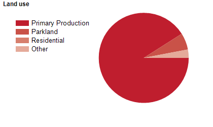
Land use
Upper Lachlan Shire is predominantly rural, with settlement based mainly in the township of Crookwell, the smaller townships of Gunning and Taralga, and the villages and centres of Bigga, Binda, Breadalbane, Collector, Dalton, Grabben Gullen, Jerrawa, Laggan and Tuena. The Shire encompasses a total land area of about 7,100 square kilometres. Rural land is used mainly for agriculture, particularly sheep and cattle grazing, with some wheat, crop and potato growing and viticulture. Tourism is also an important industry.
Transport
Upper Lachlan Shire is served by the Hume Highway, the Federal Highway and the Melbourne-Sydney railway line.
Major features
- Major features of the Shire include Abercrombie River National Park,
- Blue Mountains National Park,
- Keverstone National Park,
- Tarlo River National Park,
- Wombeyan Karst Conservation Reserve,
- Keverstone State Conservation Area,
- Wombeyan Caves,
- Mundoonen Nature Reserve,
- Razorback Nature Reserve,
- Grabine Lakeside Holiday Park,
- part of Lake Wyangala,
- Crookwell Wind Farm,
- Gullen Range Wind Farm,
- Taralga Wind Farm,
- The Lachlan River and the Crookwell Central Business District.
Included areas
- Upper Lachlan Shire encompasses the localities of Bannaby,
- Bannister,
- Bellmount Forest (part),
- Bevendale,
- Biala,
- Big Hill,
- Bigga,
- Binda,
- Blakney Creek,
- Brayton (part),
- Breadalbane,
- Broadway,
- Chatsbury,
- Collector (part),
- Crooked Corner,
- Crookwell,
- Cullerin,
- Currawang (part),
- Curraweela,
- Dalton,
- Fullerton,
- Golspie,
- Grabben Gullen,
- Greenwich Park (part),
- Gunning,
- Gurrundah,
- Jerrawa,
- Lade Vale,
- Laggan,
- Lerida (part),
- Limerick,
- Lost River,
- Merrill,
- Middle Arm (part),
- Mount Werong (part),
- Myrtleville,
- Narrawa,
- Oolong,
- Peelwood,
- Pejar,
- Pomeroy (part),
- Richlands,
- Roslyn,
- Stonequarry,
- Taralga,
- Tarlo (part),
- Tuena,
- Wayo (part),
- Wheeo,
- Wiarborough (part),
- Wollogorang (part),
- Wombeyan Caves (part),
- Woodhouselee (part) and Yalbraith.