Tweed Shire
About the profile areas
The 2023 Estimated Resident Population for Tweed Shire is 98,967, with a population density of 75.57 persons per square km.
Location and boundaries
Tweed Shire is located in the north-east corner of New South Wales, about 860 kilometres north of the Sydney CBD and around 100 kilometres south of the Brisbane CBD. Tweed Shire is bounded by the Queensland border, the Scenic Rim Regional Council area and Gold Coast City in the north, the Coral Sea in the east, Byron Shire and Lismore City in the south, and the Kyogle Council area in the west.
Traditional Owners
The original inhabitants of the Tweed area were the Bundjalung Aboriginal people.
Name origin
Tweed Shire is named after the Tweed River, which is named after the Tweed River which runs along the English and Scottish border.
Important
|
Population98,967 2023 ABS ERP |
Land area1,310 square km |
Population density75.57 persons per square km |
Settlement history
European settlement dates from 1844, with land used mainly for timber-getting and farming. Population was minimal until the 1880s, with growth during the late 1800s. Significant development did not occur until the post-war years, with the population of the Shire increasing from about 19,000 in 1947 to 22,000 in 1961, then to 25,000 in 1971. Rapid growth took place from the 1980s, aided by tourism, with growth particularly in the suburbs along the coast and to the south of Tweed Heads. The population increased from about 40,000 in 1981 to 56,000 in 1991, and then to about 86,000 in 2011. Growth is expected to continue.
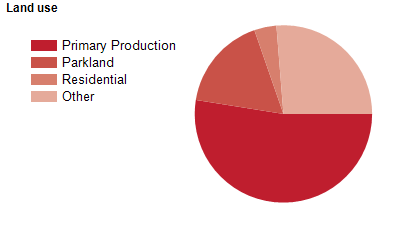
Land use
Tweed Shire encompasses rural areas, national parks, growing residential and rural-residential areas, and some commercial and industrial land use. The urban areas are concentrated in the north-east corner (Tweed Heads), with an inland urban centre at Murwillumbah, and several smaller townships and villages. The Shire encompasses a total land area of about 1,300 square kilometres, including significant areas of coastline, national park, wetland and forest. Rural land is used largely for agriculture, particularly sugar cane growing, beef and dairy farming, and crop growing, with some forestry and tourism.
Transport
Tweed Shire is served by the Pacific Highway.
Major features
- Major features of the Shire include Border Ranges National Park,
- Mebbin National Park,
- Mooball National Park,
- Mount Jerusalem National Park,
- Nightcap National Park,
- Wollumbin National Park,
- Mount Warning,
- Ilnam Estate (winery),
- Lisnagar Historic Homestead,
- Madura Tea Estates,
- Minjungbal Aboriginal Cultural Centre,
- Tropical Fruit World,
- Tweed Maritime Museum,
- Tweed River Art Gallery,
- Tweed River Regional Museum,
- World Heritage Rainforest and Information Centre,
- The Tweed Heads CBD,
- The Murwillumbah CBD,
- Tweed City Shopping Centre,
- North Coast TAFE (Kingscliff and Murwillumbah Campuses),
- Southern Cross University (Riverside Campus),
- Tweed Heads District Hospital,
- Murwillumbah District Hospital,
- Tweed Regional Aquatic Centre,
- Kingscliff Pool,
- Tweed Heads Indoor Pool,
- Chinderah Golf Course,
- Club Banora Golf Club,
- Coolangatta & Tweed Heads Golf Club,
- Murwillumbah Golf Club,
- Murwillumbah Civic and Cultural Centre,
- Billinudgel Nature Reserve,
- Couchy Creek Nature Reserve,
- Cudgen Nature Reserve,
- Hattons Bluff Nature Reserve,
- Limpinwood Nature Reserve,
- Mount Nullum Nature Reserve,
- Numinbah Nature Reserve,
- Stotts Island Nature Reserve,
- Tweed Estuary Nature Reserve,
- Ukerebagh Nature Reserve,
- Wooyung Nature Reserve,
- Wollumbin State Conservation Area,
- The Tweed River,
- Cobaki Broadwater,
- Terranora Broadwater,
- Cudgen Lake,
- Clarrie Hall Dam and various beaches and small islands.
Included areas
- Tweed Shire includes the suburbs,
- townships and localities of Back Creek,
- Banora Point,
- Bilambil,
- Bilambil Heights,
- Bogangar,
- Bray Park,
- Brays Creek,
- Bungalora,
- Burringbar,
- Byangum,
- Byrrill Creek,
- Cabarita Beach,
- Carool,
- Casuarina,
- Cedar Creek,
- Chillingham,
- Chinderah,
- Chowan Creek,
- Clothiers Creek,
- Cobaki,
- Cobaki Lakes,
- Commissioners Creek,
- Condong,
- Crabbes Creek,
- Crystal Creek,
- Cudgen,
- Cudgera Creek,
- Doon Doon,
- Dulguigan,
- Dum Dum,
- Dunbible,
- Dungay,
- Duranbah,
- Duroby,
- Eungella,
- Eviron,
- Farrants Hill,
- Fernvale,
- Fingal Head,
- Glengarrie,
- Hastings Point,
- Hopkins Creek,
- Kielvale,
- Kings Forest,
- Kingscliff,
- Kunghur,
- Kunghur Creek,
- Kynnumboon,
- Limpinwood,
- Mebbin,
- Midginbil,
- Mooball,
- Mount Burrell,
- Mount Warning,
- Murwillumbah,
- Nobbys Creek,
- North Arm,
- North Tumbulgum,
- Numinbah,
- Nunderi,
- Palmvale,
- Piggabeen,
- Pottsville,
- Pumpenbil,
- Reserve Creek,
- Round Mountain,
- Rowlands Creek,
- Sleepy Hollow,
- Smiths Creek,
- South Murwillumbah,
- Stokers Siding,
- Stotts Creek,
- Tanglewood,
- Terragon,
- Terranora,
- Tomewin,
- Tumbulgum,
- Tweed Heads,
- Tweed Heads South,
- Tweed Heads West,
- Tyalgum,
- Tyalgum Creek,
- Tygalgah,
- Uki,
- Upper Burringbar,
- Upper Crystal Creek,
- Upper Duroby,
- Urliup,
- Wardrop Valley,
- Wooyung (part) and Zara.