City of Swan
About the profile areas
The 2023 Estimated Resident Population for the City of Swan is 171,588, with a population density of 164.7 persons per square km.
Location and boundaries
The City of Swan is located on the north-eastern fringe of Perth, 10-50 kilometres north-east of the Perth CBD. The City of Swan is bounded by the Shires of Chittering and Toodyay in the north, the Shire of Mundaring in the east and south-east, the City of Kalamunda, the City of Belmont, the Town of Bassendean and the City of Bayswater in the south, and the Cities of Stirling and Wanneroo in the west.
Traditional Owners
The original inhabitants of the Swan area were the Nyungar Aboriginal people.
Name origin
Swan is named after the Swan River, which was named after black swans seen on the river.
Important
|
Population171,588 2023 ABS ERP |
Land area1,042 square km |
Population density164.7 persons per square km |
Settlement history
European settlement dates from 1829 when the first land grants were made, with the township of Guildford established soon after this. Growth was minimal until the 1880s. Gradual expansion took place from the late 1800s into the early 1900s, especially around the railway head at Midland. Significant development occurred in the post-war years, particularly from the late 1960s. Rapid growth took place from the 1980s. The population of the City doubled between 1991 and 2011, rising from under 52,000 in 1991 to nearly 106,000 in 2011, with most of this growth in the new urban areas of Ellenbrook, The Vines, Ballajura, Stratton and Jane Brook, and more recently from redevelopment in Midland. Population growth is expected to continue, particularly in Ellenbrook, Henley Brook and Midland.
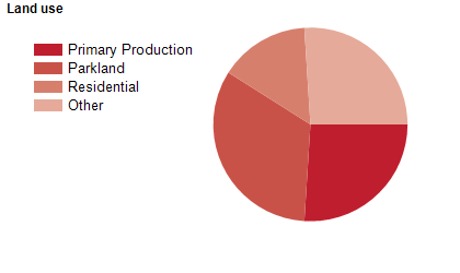
Land use
The City of Swan is a predominantly rural area, with rapidly expanding residential areas and some commercial and industrial land uses. The City encompasses a total land area of about 1,040 square kilometres, of which a significant proportion is National Park, State Forest and nature reserves. Much of the rural area is used for forestry, agriculture and grazing, with an increasing number of viticulture industries in more recent years.
Transport
The City of Swan is served by the Great Eastern Highway, the Great Northern Highway, the Reid Highway, the Roe Highway, the Tonkin Highway and the Midland railway line.
Major features
- Major features of the City include the Swan River,
- Avon Valley National Park,
- John Forrest National Park,
- Walyunga National Park,
- Caversham Wildlife Park,
- West Australian Reptile Park,
- Museum of Natural History,
- Whiteman Park,
- SpeedDome,
- Ellenbrook Speedway,
- Perth Ice Arena,
- WA International Shooting Complex,
- RAAF Base Pearce,
- Palmer Barracks (Navy),
- Polytechnic West (Midland Campus),
- Swan District Hospital,
- The Swan Valley Heritage Cycle Trail and various wineries.
Included areas
- The City of Swan includes the suburbs and localities of Aveley,
- Avon Valley National Park,
- Ballajura,
- Baskerville,
- Beechboro,
- Belhus,
- Bellevue (part),
- Bennett Springs,
- Brabham,
- Brigadoon,
- Bullsbrook,
- Caversham,
- Cullacabardee,
- Dayton,
- Ellenbrook,
- Gidgegannup,
- Guildford,
- Hazelmere,
- Henley Brook,
- Herne Hill,
- Jane Brook,
- Kiara,
- Koongamia,
- Lexia,
- Lockridge,
- Malaga,
- Melaleuca,
- Middle Swan,
- Midland,
- Midvale (part),
- Millendon,
- Perth Airport (part),
- Red Hill,
- South Guildford,
- Stratton,
- Swan View (part),
- The Vines,
- Upper Swan,
- Viveash,
- Walyunga National Park,
- West Swan,
- Whiteman and Woodbridge.