Strathbogie Shire
About the profile areas
The 2023 Estimated Resident Population for Strathbogie Shire is 11,578, with a population density of 3.51 persons per square km.
Location and boundaries
Strathbogie Shire is located in north-central Victoria, about 150 kilometres north of the Melbourne CBD. Strathbogie Shire is bounded by the Shire of Campaspe and the City of Greater Shepparton in the north, Benalla Rural City in the east, Mansfield Shire, Murrindindi Shire and Mitchell Shire in the south, and the City of Greater Bendigo in the west.
Traditional Owners
The original inhabitants of Strathbogie Shire were the Ngurelban Aboriginal people.
Name origin
Strathbogie Shire is named after an early property in the area, which was thought to be named after the valley of the Bogie River in Aberdeen, Scotland.
Important
|
Population11,578 2023 ABS ERP |
Land area3,302 square km |
Population density3.51 persons per square km |
Settlement history
European settlement dates from the 1830s, with land used mainly for grazing and crop farming. Growth took place in the 1850s, spurred by the gold rush. More substantial development occurred during the late 1800s, aided by the construction of railway lines. Growth continued during the post-war years. The population increased gradually during the 1990s, was relatively stable during the early 2000s, with gradual growth resuming in recent years.
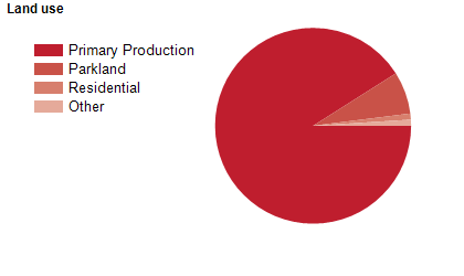
Land use
Strathbogie Shire is a predominantly rural area. The main townships are Avenel, Euroa, Nagambie and Violet Town, with smaller townships at Graytown, Longwood, Ruffy and Strathbogie. The Shire encompasses a total land area of 3,300 square kilometres. Land is used mainly for agriculture, particularly wool, grain, cattle, horse studs and vineyards.
Transport
Strathbogie Shire is served by the Goulburn Valley Freeway, the Hume Freeway, the Goulburn Valley Highway, and the Melbourne-Shepparton, Melbourne-Wodonga railway lines and Mangalore Airport.
Major features
- Major features of Strathbogie Shire include Heathcote-Graytown National Park,
- The Strathbogie Ranges,
- The Goulburn River,
- Goulburn Weir,
- Lake Nagambie,
- Nagambie Lakes Regatta Centre,
- Gooram Falls,
- Avenel Maze and numerous wineries.
Included areas
- Strathbogie Shire includes the localities of Arcadia South,
- Avenel (part),
- Baddaginnie (part),
- Bailieston,
- Balmattum,
- Boho,
- Boho South (part),
- Creek Junction (part),
- Creightons Creek,
- Earlston,
- Euroa,
- Gooram (part),
- Goulburn Weir,
- Graytown,
- Kelvin View,
- Kirwans Bridge,
- Kithbrook,
- Koonda,
- Locksley,
- Longwood,
- Longwood East,
- Mangalore (part),
- Marraweeney,
- Miepoll,
- Mitchellstown,
- Moglonemby,
- Molka,
- Moorilim (part),
- Moormbool West,
- Nagambie,
- Nalinga (part),
- Pranjip,
- Riggs Creek,
- Ruffy (part),
- Sheans Creek,
- Strathbogie,
- Tabilk,
- Tamleugh,
- Tarcombe (part),
- Upotipotpon,
- Upton Hill,
- Violet Town (part),
- Wahring,
- Whroo (part) and Wirrate.