SSROC region
About the profile areas
The 2023 Estimated Resident Population for the SSROC region is 1,824,928, with a population density of 2,634 persons per square km.
Location and boundaries
The SSROC (Southern Sydney Regional Organisation of Councils) region is located in the southern area of Sydney. The SSROC region is bounded by Sydney Harbour in the north, the Tasman Sea in the east, Wollongong City in the south, and Campbelltown City, Liverpool City, Fairfield City, the Cumberland Council area and the City of Parramatta in the west.
Traditional Owners
The original inhabitants of the SSROC region were the Eora Aboriginal people, including the Biddegal, Bidjigal, Birrabirragal, Cadigal, Dharawal, Dharug, Gweagal, Kameygal and Wangal clans.
Important
|
Population1,824,928 2023 ABS ERP |
Land area692.7 square km |
Population density2,634 persons per square km |
Settlement history
European settlement of the area dates from 1788, following the arrival of the First Fleet at Sydney Cove. Land was used mainly for timber getting and farming, and later market gardening. Population was minimal until the mid 1800s, spurred by improved access and the gold rush. More substantial growth took place in the 1870s and 1880s, aided by industrial growth. Residential and industrial expansion continued during the early 1900s and the interwar period. The most significant development occurred during the post-war years, when many flats and apartments were built. The population gradually declined during the 1970s, and then stabilised during the 1980s. The population of the region has increased since the early 1990s, rising from about 1,268,000 in 1991 to about 1,500,000 in 2011. The bulk of the recent growth has been in the City of Canterbury Bankstown and the City of Sydney, largely due to infill development, town centre development, high density housing and the redevelopment of former industrial sites.
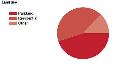
Land use
The SSROC region is a predominantly residential area, with substantial commercial and industrial areas, and some military land use. The SSROC region encompasses a total land area of about 700 square kilometres, including significant waterways and coastal areas. The LGA with the largest population in the SSROC region is the City of Canterbury Bankstown, with the Burwood Council area having the smallest population.
Transport
The SSROC region is served by the Bradfield Highway, the Hume Highway (Liverpool Road), the Princes Highway, the South Western Motorway (M5), the Western Motorway, the Cahill Expressway, Parramatta Road, Sydney Airport, Bankstown Airport and numerous railway lines, buses and ferries.
Major features
- Major features of the SSROC region include Georges River National Park,
- Heathcote National Park,
- Kamay Botany Bay National Park,
- Malabar Headland National Park,
- Royal National Park,
- Sydney Harbour National Park,
- Mirambeena Regional Park,
- Wolli Creek Regional Park,
- Deepwater Park,
- The Sydney CBD,
- The Bondi Junction Business District,
- Westfield Hurstville Shopping Centre,
- numerous smaller shopping centres,
- The Cooks River,
- The Georges River,
- The Hacking River,
- The Parramatta River,
- Sydney Harbour,
- Botany Bay,
- Darling Harbour,
- Circular Quay,
- Port Botany,
- numerous beaches including Bondi Beach,
- Potts Hill Reservoirs,
- Central Queensland University (Sydney Campus),
- Sydney College of the Arts - The University of Sydney,
- Sydney TAFE (Design Centre Enmore and Eora,
- Petersham,
- Randwick,
- St George,
- Sutherland and Ultimo Colleges),
- TAFE NSW South Western Sydney Institute (Bankstown,
- Chullora and Padstow Colleges),
- The University of New South Wales (CBD,
- Cliffbrook,
- Kensington,
- Paddington and Randwick Campuses),
- The University of Notre Dame Australia (Broadway and Darlinghurst Campuses),
- The University of Sydney (Conservatorium of Music,
- Sydney Law School and Burren Street,
- Camperdown/Darlington,
- Mallett Street and Surry Hills Campuses),
- University of Technology Sydney (City Campus),
- University of Tasmania (Darlinghurst and Rozelle Campuses),
- University of Wollongong (Southern Sydney Campus),
- Western Sydney University (Bankstown and Sydney City Campuses),
- Sydney Airport,
- Holsworthy Military Reserve,
- HMAS Watson,
- Randwick Barracks,
- Long Bay Correctional Complex,
- Sydney Cricket Ground,
- Allianz Stadium,
- UOW Jubilee Oval,
- Shark Park,
- Dunc Gray Velodrome,
- Canterbury Park Racecourse,
- Randwick Racecourse,
- Sydney Harbour Bridge,
- Sydney Opera House,
- Sydney Tower Eye & Skywalk,
- and numerous sporting facilities,
- golf courses,
- aquatic centres,
- museums,
- hospitals,
- wharves,
- marinas,
- baths,
- parks and reserves.
Included areas
- The SSROC region includes the eleven member councils of Bayside Council,
- Burwood Council,
- City of Canada Bay,
- City of Canterbury Bankstown,
- Georges River Council,
- Inner West Council,
- Randwick City,
- Strathfield Council,
- Sutherland Shire,
- City of Sydney,
- Waverley Council and Woollahra Municipal Council.