Southern Grampians Shire
About the profile areas
The 2023 Estimated Resident Population for Southern Grampians Shire is 16,470, with a population density of 2.48 persons per square km.
Location and boundaries
Southern Grampians Shire is located in south-western Victoria, about 290 kilometres west of the Melbourne CBD. Southern Grampians Shire is bounded by Horsham Rural City and Northern Grampians Shire in the north, Ararat Rural City in the east, Moyne Shire in the south, and Glenelg Shire and West Wimmera Shire in the west.
Traditional Owners
The original inhabitants of Southern Grampians Shire were the Bunganditj, Gunditjmara and Tjap Wurrung Aboriginal people.
Name origin
Southern Grampians Shire is named for the southern part of the Grampian ranges, which were named after mountains in Scotland.
Important
|
Population16,470 2023 ABS ERP |
Land area6,652 square km |
Population density2.48 persons per square km |
Settlement history
European settlement dates from 1837, with land used mainly for grazing. Growth was minimal until the 1850s when several townships were established. Substantial expansion took place from the 1880s into the early 1900s, aided by the construction of the railway line and the opening up of land. The most significant development occurred in the immediate post-war years. The population gradually declined from the late 1970s.
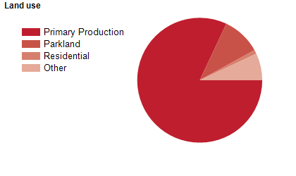
Land use
Southern Grampians Shire is a predominantly rural area, with significant residential areas in the townships of Balmoral, Branxholme, Byaduk, Cavendish, Coleraine, Dunkeld, Glenthompson, Hamilton, Penshurst and Tarrington. The major town is Hamilton, which accommodates about half of the Shire's population. The Shire encompasses a total land area of 6,652 square kilometres, including substantial national and state parks. Much of the rural area is used for agriculture and sheep grazing, with some mining.
Transport
Southern Grampians Shire is served by the Glenelg Highway, the Hamilton Highway and the Henty Highway.
Major features
- Major features of Southern Grampians Shire include Grampians National Park,
- Mount Napier State Park,
- Byaduk Caves,
- Nigretta Falls,
- Wannon Falls,
- Rocklands Reservoir,
- Lake Hamilton,
- Lake Linlithgow,
- Hamilton Botanic Gardens,
- South West TAFE (Hamilton Campus),
- RMIT University Hamilton,
- Hamilton Institute of Rural Learning,
- The Wannon River and the Glenelg River.
Included areas
- Southern Grampians Shire includes the localities of Balmoral,
- Bellfield (part),
- Bochara,
- Branxholme (part),
- Brit Brit,
- Buckley Swamp,
- Bulart,
- Byaduk (part),
- Byaduk North,
- Caramut (part),
- Carapook (part),
- Cavendish,
- Cherrypool,
- Clover Flat (part),
- Coleraine,
- Coojar,
- Croxton East,
- Culla,
- Dunkeld (part),
- Englefield,
- Gatum,
- Gazette (part),
- Glenisla (part),
- Glenthompson (part),
- Grampians,
- Gringegalgona,
- Gritjurk,
- Hamilton,
- Harrow (part),
- Hensley Park,
- Hilgay,
- Karabeal,
- Konongwootong,
- Melville Forest,
- Mirranatwa,
- Mooralla,
- Morgiana,
- Mount Napier,
- Moutajup,
- Muntham (part),
- Nareeb (part),
- Nareen (part),
- Penshurst (part),
- Pigeon Ponds,
- Purdeet (part),
- Rocklands,
- Strathkellar,
- Tabor,
- Tahara (part),
- Tarrayoukyan (part),
- Tarrenlea,
- Tarrington,
- Vasey,
- Victoria Point,
- Victoria Valley,
- Wando Vale (part),
- Wannon,
- Warrayure,
- Woodhouse,
- Wootong Vale,
- Yatchaw and Yulecart.