South Gippsland Shire
About the profile areas
The 2023 Estimated Resident Population for South Gippsland Shire is 30,823, with a population density of 9.35 persons per square km.
Location and boundaries
South Gippsland Shire is located in south-eastern Victoria, about 100 kilometres south-east of the Melbourne CBD. South Gippsland Shire is bounded by Cardinia Shire and Baw Baw Shire in the north, Latrobe City and Wellington Shire in the east, Bass Strait in the south, and Bass Coast Shire in the west.
Traditional Owners
The original inhabitants of South Gippsland Shire were the Gunnai, Bun Wurrung and Wurundjeri Aboriginal people.
Name origin
South Gippsland Shire is named for the southern part of Gippsland, which was named after Sir George Gipps, former NSW Governor.
Important
|
Population30,823 2023 ABS ERP |
Land area3,295 square km |
Population density9.35 persons per square km |
Settlement history
European settlement dates from the 1840s, with land used mainly for timber-getting, farming and grazing. Population was minimal until the 1860s when land was opened for selection, leading to the development of a farming community (dairy, cheese making, agriculture, sheep and cattle breeding). Growth took place from the 1880s into the early 1900s, when many villages were established, spurred by coal mining and the construction of railway lines. Significant development occurred during the interwar period and the post-war years, aided by soldier settlement. The population increased slightly during the 1980s and 1990s, with more consistent growth from the early 2000s.
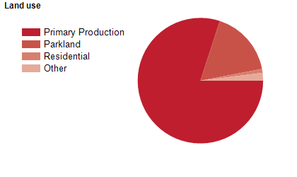
Land use
South Gippsland Shire is a rural, residential and holiday area. The Shire encompasses a total land area of 3,295 square kilometres, including substantial coastal areas. The major towns are Leongatha, Korumburra, Mirboo North and Foster, with smaller townships at Dumbalk, Fish Creek, Loch, Meeniyan, Nyora, Poowong, Port Welshpool, Sandy Point, Tarwin Lower, Toora, Venus Bay and Welshpool, and many other small communities. Much of the rural area is used for timber production and agriculture, with dairy, beef and snow pea farming being the main agricultural pursuits. There is also some fishing and viticulture. Tourism is an important industry, especially in the coastal areas.
Transport
South Gippsland Shire is served by the Bass Highway, the South Gippsland Highway and the Strzelecki Highway.
Major features
- Major features of South Gippsland Shire include Wilsons Promontory National Park,
- Cape Liptrap Coastal Park,
- various beaches,
- The Strzelecki Ranges,
- Coal Creek Community Park and Museum,
- The Great Southern Rail Trail,
- Grand Ridge Rail Trail,
- Nyora Raceway,
- Stony Creek Racecourse,
- Mirboo North Regional Park,
- Agnes Falls,
- Federation Training (Leongatha Campus),
- Grand Ridge Brewery and several wineries.
Included areas
- South Gippsland Shire includes the localities of Agnes,
- Allambee Reserve (part),
- Allambee South (part),
- Arawata,
- Baromi,
- Bena,
- Bennison,
- Berrys Creek,
- Binginwarri (part),
- Boolarong,
- Boolarra (part),
- Boorool,
- Buffalo,
- Darlimurla (part),
- Delburn (part),
- Dollar,
- Dumbalk,
- Dumbalk North,
- Fairbank,
- Fish Creek,
- Foster,
- Foster North,
- Gunyah,
- Hallston,
- Hazel Park,
- Hedley (part),
- Inverloch (part),
- Jeetho,
- Jumbunna,
- Kardella,
- Kardella South,
- Kongwak (part),
- Koonwarra,
- Koorooman,
- Korumburra,
- Korumburra South,
- Krowera (part),
- Lang Lang (part),
- Leongatha,
- Leongatha North,
- Leongatha South,
- Loch,
- Mardan,
- Meeniyan,
- Middle Tarwin,
- Mirboo (part),
- Mirboo North,
- Mount Best,
- Mount Eccles,
- Mount Eccles South,
- Moyarra,
- Nerrena,
- Nyora (part),
- Outtrim (part),
- Poowong,
- Poowong East (part),
- Poowong North (part),
- Port Franklin,
- Port Welshpool,
- Pound Creek,
- Ranceby,
- Ruby,
- Sandy Point,
- Stony Creek,
- Strzelecki (part),
- Tarwin,
- Tarwin Lower,
- Thorpdale (part),
- Thorpdale South (part),
- Tidal River,
- Toora,
- Toora North (part),
- Trida (part),
- Turtons Creek,
- Venus Bay,
- Walkerville,
- Walkerville North,
- Walkerville South,
- Waratah Bay,
- Welshpool,
- Whitelaw,
- Wild Dog Valley,
- Wilsons Promontory,
- Wonga,
- Wonyip,
- Woorarra East (part),
- Woorarra West,
- Wooreen and Yanakie.