Shoalhaven City
About the profile areas
The 2023 Estimated Resident Population for Shoalhaven City is 109,895, with a population density of 24.06 persons per square km.
Location and boundaries
Shoalhaven City is located on the south coast of New South Wales, about 160 kilometres south of the Sydney CBD. Shoalhaven City is bounded by the Wingecarribee Shire and the Municipality of Kiama in the north, the Tasman Sea and Jervis Bay Territory in the east, the Eurobodalla Shire in the south, and the Queanbeyan-Palerang Regional Council area and the Goulburn Mulwaree Council area in the west.
Traditional Owners
The original inhabitants of Shoalhaven City were the Wodi Wodi and Wandandian Aboriginal people.
Name origin
Shoalhaven City is named after the Shoalhaven River, which was named "Shoals Haven" by George Bass.
Important
|
Population109,895 2023 ABS ERP |
Land area4,567 square km |
Population density24.06 persons per square km |
Settlement history
European settlement dates from 1822 when land was taken up near the mouth of the Shoalhaven River. Land was progressively cleared for agriculture and timber-getting. By the 1850s townships were established in Berry, Bomaderry, Kangaroo Valley, Milton, Nowra and Ulladulla, acting as service centres for the surrounding farming districts. Some growth took place in the late 1800s. Significant development occurred during the post-war years, particularly in the coastal areas. Rapid growth took place in the 1970s and 1980s, as increasing numbers of people sought housing for retirement and holidays. The population grew from about 29,000 in 1971 to nearly 58,000 in 1981. The population continued to increase from the 1990s, rising from about 68,000 in 1991 to about 98,000 in 2016. Much of the recent growth has been in the localities of Sanctuary Point and Worrigee.
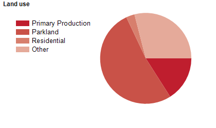
Land use
Shoalhaven City is a regional and growing residential and tourist area, it is the most visited LGA in NSW outside of Sydney. The City encompasses a total land area of about 4,561 square kilometres, including substantial areas of national park, state forest, bushland, beaches and lakes. Most of the population is concentrated along the coastal fringe, in major centres and numerous small settlements. The major centres are Nowra-Bomaderry, Milton-Ulladulla, Huskisson-Vincentia, St Georges Basin District, Culburra Beach and Sussex Inlet. Rural land is used mainly for dairy farming, beef cattle, nurseries, and a growing number of more intensive agricultural activities. The area has a strong light manufacturing industrial base including goods such as paper, starches, ethanol, cheese, boats, avionics, building products, surfboard and surf-wear. The main sectors of employment within the Shoalhaven are Manufacturing, Government (including Defence), Retail and Tourism. These sectors are supported by Building and Construction, Community Services and Education.
Transport
Shoalhaven City is served by the Princes Highway and the Illawarra (Bomaderry) railway line.
Major features
- Major features of the City include TAFE NSW Illawarra Institute (Nowra and Ulladulla Campuses),
- University of Wollongong (Shoalhaven Campus),
- Jervis Bay Marine Park,
- various National Parks (Bimberamala,
- Budawang,
- Budderoo,
- Bugong,
- Conjola,
- Jerrawangala,
- Jervis Bay,
- Meroo,
- Morton,
- Murramarang and Seven Mile Beach),
- Barnunj State Conservation Area,
- Colymea State Conservation Area,
- Corramy State Conservation Area,
- Nowra Central Business District,
- Stockland Nowra (shopping centre),
- HMAS Albatross,
- Fleet Air Arm Museum,
- Shoalhaven Zoo,
- Dolphin Watch Cruises,
- Nowra Speedway,
- South Coast Correctional Centre,
- The Shoalhaven River,
- Jervis Bay,
- St Georges Basin,
- several wineries and numerous nature reserves,
- state forests,
- lakes and beaches.
Included areas
- Shoalhaven City includes the localities of Back Forest,
- Bamarang,
- Bangalee,
- Barrengarry,
- Barren Grounds (part),
- Barringella,
- Basin View,
- Bawley Point,
- Beaumont,
- Beecroft Peninsula,
- Bellawongarah,
- Bendalong,
- Berrara,
- Berringer Lake,
- Berry,
- Berry Mountain,
- Bewong,
- Bolong,
- Bomaderry,
- Boolijah,
- Bream Beach,
- Brogers Creek (part),
- Brooman,
- Broughton,
- Broughton Vale,
- Broughton Village (part),
- Browns Mountain,
- Brundee,
- Buangla,
- Budawang (part),
- Budderoo (part),
- Budgong,
- Bulee,
- Bundewallah,
- Burrier,
- Burrill Lake,
- Callala Bay,
- Callala Beach,
- Cambewarra,
- Cambewarra Village,
- Cockwhy,
- Comberton,
- Comerong Island,
- Conjola,
- Conjola Park,
- Coolangatta,
- Coolumburra,
- Croobyar,
- Cudmirrah,
- Culburra Beach,
- Cunjurong Point,
- Currarong,
- Currowan (part),
- Depot Beach,
- Dolphin Point,
- Durras North,
- East Lynne,
- Endrick,
- Erowal Bay,
- Ettrema,
- Falls Creek,
- Far Meadow,
- Fishermans Paradise,
- Greenwell Point,
- Huskisson,
- Hyams Beach,
- Illaroo,
- Jaspers Brush,
- Jerrawangala,
- Kangaroo Valley,
- Kinghorne,
- Kings Point,
- Kioloa,
- Lake Conjola,
- Lake Tabourie,
- Little Forest,
- Longreach,
- Manyana,
- Mayfield,
- Meroo Meadow,
- Milton,
- Mogood,
- Mollymook,
- Mollymook Beach,
- Mondayong,
- Moollattoo,
- Morton,
- Mount Kingiman,
- Mundamia,
- Myola,
- Narrawallee,
- North Nowra,
- Nowra,
- Nowra Hill,
- Numbaa,
- Old Erowal Bay,
- Orient Point,
- Parma,
- Pebbly Beach,
- Pointer Mountain,
- Porters Creek,
- Pretty Beach,
- Pyree,
- Quiera,
- Red Rocks,
- Sanctuary Point,
- Sassafras,
- Shoalhaven Heads,
- South Nowra,
- St George,
- St Georges Basin,
- Sussex Inlet,
- Swanhaven,
- Tallowal,
- Tapitallee,
- Terara,
- Termeil,
- Tianjara,
- Tolwong,
- Tomerong,
- Touga,
- Tullarwalla,
- Twelve Mile Peg,
- Ulladulla,
- Upper Kangaroo River,
- Vincentia,
- Wandandian,
- Watersleigh,
- Wattamolla,
- West Nowra,
- Wollumboola,
- Woodburn,
- Woodhill,
- Woodstock,
- Woollamia,
- Worrigee,
- Worrowing Heights,
- Wrights Beach,
- Yadboro,
- Yalwal,
- Yatte Yattah and Yerriyong.