Shellharbour City
About the profile areas
The 2023 Estimated Resident Population for Shellharbour City is 79,738, with a population density of 540.8 persons per square km.
Location and boundaries
Shellharbour City is located in the Illawarra Region of New South Wales, about 100 kilometres south of the Sydney CBD. Shellharbour City is bounded by Wollongong City in the north, the Tasman Sea in the east, the Municipality of Kiama in the south and Wingecarribee Shire in the west.
Traditional Owners
The original inhabitants of the Shellharbour area were the Wodi Wodi tribe of the Thurawal Aboriginal people.
Name origin
Shellharbour is named due to the abundance of shells in the area. It was originally known as Peterborough.
Important
|
Population79,738 2023 ABS ERP |
Land area147.4 square km |
Population density540.8 persons per square km |
Settlement history
European settlement dates from 1817, when the first land grants were made. Land was used mainly for sheep and cattle grazing, wheat growing and cedar-getting. Growth was minimal until the 1850s when the Shellharbour township was laid out. Expansion took place in the 1880s and 1890s, spurred by the construction of the railway line, the dairy industry, basalt mining and coal mining. Growth continued in the early 1900s, aided by the construction of many holiday houses. The southern areas developed quicker than the north, due to better road access. Significant development occurred during the 1950s and 1960s, spurred by industrial growth in nearby Port Kembla and the construction of public housing estates. Growth took place particularly in the eastern areas, around Warilla, Mount Warrigal, Barrack Point and Barrack Heights. The population increased during the 1990s, rising from 46,000 in 1991 to 57,000 in 2001, then continuing to increase to nearly 63,000 in 2011. This growth was mainly in the southern and western areas, particularly in Albion Park, Flinders, Shell Cove, Shellharbour City Centre and Tullimbah. Population growth is expected to continue.
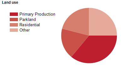
Land use
Shellharbour City is an expanding urban area with significant rural areas and some industrial and commercial land uses. The City encompasses a total land area of about 155 square kilometres, including beaches, rivers, National and State Parks and other significant parklands. The main urban centres are Shellharbour City Centre, Albion Park and Oak Flats. Most of the rural areas are in the south and west, with rural land used mainly for crop farming, dairy farming and grazing.
Transport
Shellharbour City is served by the Illawarra Highway, the Princes Highway, Illawarra Regional Airport and the South Coast railway line.
Major features
- Major features of the City include Macquarie Pass National Park,
- Killalea State Park,
- Bass Point Reserve (Coastal Marine Reserve),
- Blackbutt Forest Reserve,
- Myimbarr Wetlands,
- Lake Illawarra,
- Croom Regional Sporting Complex,
- Stockland Shellharbour Shopping Centre,
- Shellharbour Hospital,
- TAFE NSW Illawarra Institute (Shellharbour Campus) and various beaches.
Included areas
- Shellharbour City includes the suburbs and rural localities of Albion Park,
- Albion Park Rail,
- Barrack Heights,
- Barrack Point,
- Blackbutt,
- Calderwood,
- Croom (part),
- Dunmore,
- Flinders,
- Lake Illawarra,
- Macquarie Pass,
- Mount Warrigal,
- North Macquarie,
- Oak Flats,
- Shell Cove,
- Shellharbour,
- Shellharbour City Centre,
- Tongarra,
- Tullimbar,
- Warilla and Yellow Rock (part).