Queanbeyan-Palerang Regional Council area
About the profile areas
The 2023 Estimated Resident Population for Queanbeyan-Palerang Regional Council area is 65,369, with a population density of 12.29 persons per square km.
Location and boundaries
The Queanbeyan-Palerang Regional Council area is located in south-eastern New South Wales, between 10 and 100 kilometres east of the Canberra CBD, and between 250 and 280 kilometres south-west of the Sydney CBD. The Queanbeyan-Palerang Regional Council area is bounded by Upper Lachlan Shire and the Goulburn Mulwaree Council area in the north, Shoalhaven City and Eurobodalla Shire in the east, the Snowy Monaro Regional Council area in the south, and the Australian Capital Territory and the Yass Valley Council area in the west.
Traditional Owners
The original inhabitants of the Queanbeyan-Palerang Regional Council area were the Ngambri, Ngarigu, Ngunnawal and Walbunja Aboriginal people.
Name origin
Queanbeyan is named from an Aboriginal word meaning “clear waters”, while Palerang is named after Mount Palerang.
Important
|
Population65,369 2023 ABS ERP |
Land area5,319 square km |
Population density12.29 persons per square km |
Settlement history
European settlement dates from the 1820s, with land used mainly for sheep and cattle grazing. Several townships were established in the late 1830s. Population was minimal until the 1850s, spurred by gold discoveries and the establishment of mining. Substantial growth took place in the 1880s, aided by the construction of the railway line from Sydney, with gradual increase during the early 1900s. The most significant development occurred in the post-war years, with rapid growth from the 1960s. The population of the Council area continued to increase from the 1990s, rising from about 34,000 in 1991 to nearly 53,000 in 2011. Much of the recent growth has been in Jerrabomberra.
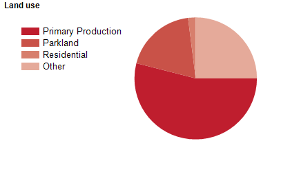
Land use
The Queanbeyan-Palerang Regional Council area is predominantly rural, with growing residential and rural-residential areas, particularly in the west, closest to Canberra. The major towns are Queanbeyan and Bungendore, with smaller townships at Braidwood and Captains Flat, and several villages. The Council area encompasses a total land area of about 5,300 square kilometres. Rural land is used mainly for sheep and cattle grazing, orchards, nurseries, crop growing, honey production and vineyards. Tourism is also an important industry.
Transport
The Queanbeyan-Palerang Regional Council area is served by the Federal Highway, the Kings Highway and the Southern railway line.
Major features
- Major features of the Council area include Budawang National Park,
- Deua National Park,
- Gourock National Park,
- Monga National Park,
- Morton National Park,
- Tallaganda National Park,
- Yanununbeyan National Park,
- Lake George,
- Googong Dam,
- TAFE NSW Illawarra Institute (Queanbeyan Campus),
- Riverside Plaza shopping centre,
- Braidwood Historic Village,
- Bungedore Village,
- Braidwood Museum,
- Queanbeyan Museum,
- Queanbeyan Printing Museum,
- Yesteryear Museum,
- The Q (Queanbeyan Performing Arts Centre),
- Heather McKay Indoor Sports Centre,
- Googong Foreshores,
- numerous Nature Reserves (Araleun,
- Bees Nest,
- Burra Creek,
- Cuumbeun,
- Goorooyarroo,
- Jerrabomberra Mountain,
- Nadgigomar,
- Queanbeyan,
- Scott,
- Stony Creek,
- Tinderry,
- Turallo,
- Wanna and Yanununbeyan),
- several wineries,
- Monga State Forest and Tallaganda State Forest.
Included areas
- The Queanbeyan-Palerang Regional Council area includes the localities of Araluen,
- Back Creek,
- Ballalaba,
- Bendoura,
- Berlang,
- Bombay,
- Boro,
- Braidwood,
- Budawang (part),
- Bungendore,
- Burra (part),
- Bywong (part),
- Captains Flat,
- Carwoola,
- Charleys Forest,
- Collector (part),
- Corang,
- Crestwood,
- Currawang (part),
- Durran Durra,
- Environa,
- Farringdon,
- Forbes Creek,
- Googong,
- Greenleigh,
- Harolds Cross,
- Hereford Hall,
- Hoskinstown,
- Jembaicumbene,
- Jerrabattgulla,
- Jerrabomberra,
- Jinden,
- Karabar,
- Kindervale,
- Krawarree,
- Lake George (part),
- Larbert,
- Majors Creek,
- Manar,
- Marlowe,
- Mayfield,
- Monga,
- Mongarlowe,
- Mount Fairy,
- Mulloon,
- Neringla (part),
- Nerriga,
- Northangera,
- Oallen (part),
- Palerang,
- Primrose Valley,
- Queanbeyan,
- Queanbeyan East,
- Queanbeyan West,
- Reidsdale,
- Rossi,
- Royalla,
- Snowball (part),
- Sutton (part),
- Tarago (part),
- The Ridgeway,
- Tinderry (part),
- Tomboye,
- Tralee,
- Urila,
- Wamboin,
- Warri,
- Williamsdale (part),
- Wog Wog,
- Wyanbene and Yarrow.