Shire of Plantagenet
About the profile areas
The 2023 Estimated Resident Population for the Shire of Plantagenet is 5,669, with a population density of 1.16 persons per square km.
Location and boundaries
The Shire of Plantagenet is located in the Great Southern Region of Western Australia, about 360 kilometres south of the Perth CBD. The Shire of Plantagenet is bounded by the Shires of Cranbrook and Gnowangerup in the north, the City of Albany in the east and south-east, the Shire of Denmark in the south, and the Shire of Manjimup in the west.
Traditional Owners
The original inhabitants of the Plantagenet area were the Bibbulmun Aboriginal people.
Important
|
Population5,669 2023 ABS ERP |
Land area4,875 square km |
Population density1.16 persons per square km |
Settlement history
European settlement dates from the 1830s, with land used mainly for grazing. Population was minimal until the late 1800s, aided by the opening of the railway line in 1889. Growth took place through to the early 1900s, with further expansion from the post-war years. The population of the Shire increased slightly during the 1990s, rising from about 4,000 in 1991 to 4,300 in 2001. The population was relatively stable between 2001 and 2006, and then increased slightly to about 4,700 in 2011.
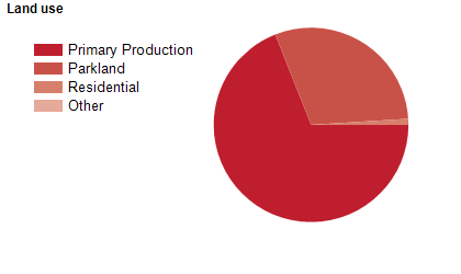
Land use
The Shire of Plantagenet is predominantly rural, with residential areas in the township of Mount Barker and several rural-residential villages. Mount Barker is the commercial centre of the Shire, with smaller settlements at Kendenup, Narrikup, Porongurup and Rocky Gully. Land is used largely for agriculture, particularly sheep and cattle grazing, with some viticulture, canola, wheat and olive growing, plantation timber growing and tourism. The Shire encompasses a total land area of about 4,800 square kilometres.
Transport
The Shire of Plantagenet is served by the Albany Highway and the Muirs Highway.
Major features
- Major features of the Shire include Stirling Range National Park,
- Porongurup National Park,
- part of Mount Lindesay National Park,
- The Mount Barker township,
- Great Southern Institute of Technology (Mount Barker Campus) and numerous wineries.
Included areas
- The Shire of Plantagenet includes the townships and localities of Denbarker,
- Forest Hill,
- Kendenup,
- Mount Barker,
- Narrikup,
- Perillup,
- Porongurup,
- Rocky Gully,
- Stirling Range National Park (part),
- Takalarup and Woogenellup.