Parkes Shire
About the profile areas
The 2023 Estimated Resident Population for Parkes Shire is 14,256, with a population density of 2.39 persons per square km.
Location and boundaries
Parkes Shire is located in central New South Wales, about 360 kilometres west of the Sydney CBD and 300 kilometres north-west of the Canberra CBD. Parkes Shire is bounded by Narromine Shire in the north, the Cabonne Council area in the east, Forbes Shire in the south, and Lachlan Shire in the west.
Traditional Owners
The original inhabitants of the Parkes area were the Wiradjuri Aboriginal people.
Name origin
Parkes Shire is named after Sir Henry Parkes, Prime Minister of New South Wales in 1873 when the township was named.
Important
|
Population14,256 2023 ABS ERP |
Land area5,961 square km |
Population density2.39 persons per square km |
Settlement history
European settlement dates from the 1820s, although population was minimal until 1862, spurred by gold discoveries. The township of Parkes was established in the 1860s, with growth during the late 1800s. The railway line was opened in 1893, with land then used more for agriculture. The Shire had a population of about 4,000 people in 1921. Significant development occurred from the post-war years. The population was relatively stable from the 1970s through to the early 1990s at about 14,000 people, and then increased to about 15,000 in 1996. The population then declined slightly, falling to about 14,300 in 2006, before increasing marginally to about 14,500 in 2011.
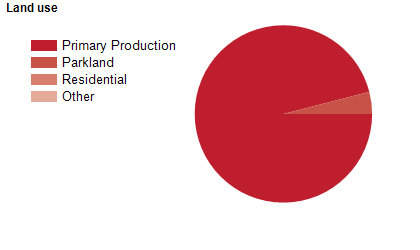
Land use
Parkes Shire is predominantly rural, with more than two-thirds of the population living in the township of Parkes. Smaller townships are located at Peak Hill, Trundle and Tullamore, with villages at Alectown, Bogan Gate and Cookamidgera. The Shire encompasses a total land area of about 5,900 square kilometres. Rural land is used largely for agriculture, particularly sheep grazing and crop growing, with some cattle grazing, copper and gold mining, and forestry.
Transport
Parkes Shire is served by the Newell Highway and the Western railway line.
Major features
- Major features of the Shire include Goobang National Park,
- CSIRO Parkes Observatory (The Dish),
- The Parkes CBD,
- Henry Parkes Museum,
- Parkes Motor Museum,
- The King’s Castle Elvis Exhibit,
- Pioneer Park Antique Machinery Collection,
- Peak Hill Open Cut Gold Mine Experience,
- Parkes Hospital,
- Bushmans Hill Reserve,
- Memorial Hill Lookout,
- Bogan Weir,
- TAFE NSW Western Institute (Parkes College),
- Northparkes Mines,
- The Bogan River and various state forests.
Included areas
- Parkes Shire includes the localities of Alectown,
- Bogan Gate,
- Bruie Plains,
- Cookamidgera (part),
- Cooks Myalls,
- Daroobalgie (part),
- Goonumbla,
- Gunningbland,
- Mandagery (part),
- Nelungaloo,
- Parkes,
- Peak Hill,
- Tichborne,
- Trewilga,
- Trundle,
- Tullamore (part) and Yarrabandai (part).