Outback Communities Authority region
About the profile areas
The 2023 Estimated Resident Population for the Outback Communities Authority region is 2,554, with a population density of 0.00 persons per square km.
Location and boundaries
The Outback Communities Authority Region is located in the Far North Region of South Australia, between 400 and 900 kilometres north of the Adelaide CBD. The Outback Communities Authority Region is bounded by the Northern Territory border in the north, the Queensland border in the north-east, the New South Wales border in the south-east, generally by the District Council of Loxton Waikerie area, the Mid Murray Council area, the Regional Council of Goyder area, the District Council of Peterborough area, the District Council of Orroroo Carrieton area, the Flinders Ranges Council area, Port Augusta City, Whyalla City, the District Council of Franklin Harbour area, the District Council of Kimba area, the Wudinna District Council area, the District Council of Streaky Bay area, the District Council of Ceduna area and the Southern Ocean in the south, and the Western Australia border, Maralinga Tjarutja Land and Anangu Pitjantjatjara Yankunytjatjara Land in the west. The Outback Communities Authority Region excludes the District Council of Coober Pedy area, the Roxby Downs Council area, the locality of Nepabunna and part of the locality of Gammon Ranges.
Traditional Owners
The original inhabitants of the Outback Communities Authority Region were various Aboriginal tribes.
Important
|
Population2,554 2023 ABS ERP |
Land area613,680 square km |
Population density0.00 persons per square km |
Settlement history
European settlement of the Region dates from the 1840s, with land used mainly for sheep and cattle grazing and grain growing. Growth took place during the late 1800s as numerous small townships developed, spurred by the establishment of gold, copper and coal mining, the surveying of the Overland Telegraph, and the construction of railway lines. More significant mining occurred from the 1940s, with open cut brown coal mining at Leigh Creek from 1941 and talc mining at Mount Fitton from 1945. The township of Woomera was established in 1947 to accommodate workers on the Woomera Rocket Range. The Rocket Range had later uses as a test and development centre, a tracking station, and an immigration detention centre, and is currently owned by the RAAF. The population of the Region fluctuated from the 1990s, although the overall pattern was one of decline, impacted by changes in the usage of the Woomera Range Complex and restructuring and reduction in the mining industry.
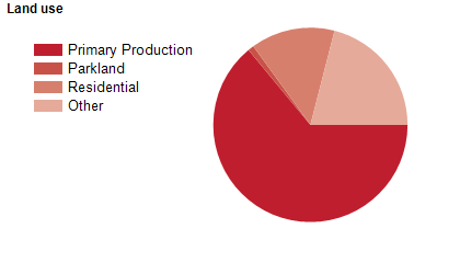
Land use
The Outback Communities Authority Region is a rural and national park area, with small townships at Andamooka, Iron Knob, Leigh Creek and Woomera, and numerous smaller townships and settlements. Land is used largely for mining and agriculture, particularly sheep and cattle grazing and grain growing. Tourism is also an important industry. The Region encompasses a total land area of about 625,000 square kilometres.
Transport
The Outback Communities Authority Region is served by the Barrier Highway, the Eyre Highway and the Stuart Highway.
Major features
- Major features of the Region include numerous National Parks (Gawler Ranges,
- Ikara-Flinders Ranges,
- Kati Thanda-Lake Eyre,
- Lake Gairdner,
- Lake Torrens,
- Malkumba-Coongie Lakes,
- Nullarbor,
- Witjira and Vulkathunha-Gammon Ranges),
- various Conservation Parks (Danggali,
- Elliot Price,
- Fowlers Bay,
- Lake Gilles,
- Pureba,
- Simpson Desert,
- Tallaringa,
- Wabma Kadarbu Mound Springs,
- Wahgunyah,
- Warraweena and Yumbarra),
- several Regional Reserves (Chowilla,
- Innamincka,
- Lake Frome,
- Nullarbor,
- Simpson Desert,
- Strzelecki and Yellabinna),
- Boolcoomata Reserve,
- Gluepot Reserve,
- Nullarbor Wilderness Protection Area,
- Bunkers Conservation Reserve,
- Chadinga Conservation Reserve,
- Point Bell Conservation Reserve,
- Aroona Sanctuary,
- Arkaroola Wilderness Sanctuary,
- Lake Blanche,
- Lake Callabonna,
- Lake Eyre,
- Lake Frome,
- Lake Gairdner,
- Lake Torrens,
- various waterholes and sandhills,
- Oodnadatta Railway Museum,
- Penong Woolshed Museum,
- Woomera Heritage Centre,
- Woomera Baker Observatory,
- Oodnadatta Health Service,
- Woomera Golf Club,
- The Woomera Range Complex (including RAAF Woomera Test Range and RAAF Base Woomera),
- The Oodnadatta Track and the Birdsville Track.
Included areas
- The Outback Communities Authority Region includes the localities of Abminga Station,
- Allandale Station,
- Alpana,
- Alton Downs Station,
- Andamooka,
- Andamooka Station,
- Angepena,
- Angorigina,
- Anna Creek,
- Arckaringa,
- Arcoona,
- Arkaroola,
- Arkaroola Village,
- Ayers Range South,
- Balah,
- Baratta,
- Beltana,
- Beltana Station,
- Benda,
- Bibliando,
- Billa Kalina,
- Bimbowrie,
- Bindarrah,
- Black Hill Station,
- Blinman,
- Bollards Lagoon,
- Bon Bon,
- Bookabie,
- Boolcoomatta,
- Bosworth,
- Buckleboo (part),
- Bulgunnia,
- Bulloo Creek,
- Bungeroo,
- Bunyung,
- Burr Well,
- Callanna,
- Calperum Station (part),
- Canegrass,
- Carriewerloo (part),
- Chowilla (part),
- Chundaria,
- Clayton Station,
- Clifton Hills Station,
- Cockburn,
- Commonwealth Hill,
- Coober Pedy (part),
- Coondambo,
- Coorabie,
- Cooyerdoo,
- Copley,
- Cordillo Downs,
- Corunna Station,
- Cowarie,
- Crown Point,
- Cultana (part),
- Curnamona,
- Danggali,
- De Rose Hill,
- Devonborough Downs,
- Dulkaninna,
- Ediacara,
- Emeroo,
- Eringa,
- Erudina,
- Etadunna,
- Evelyn Downs,
- Faraway Hill,
- Farina,
- Farina Station,
- Flinders Ranges (part),
- Florina Station,
- Fowlers Bay,
- Frome Downs,
- Gammon Ranges (part),
- Gawler Ranges,
- Gidgealpa,
- Gilles Downs,
- Gluepot,
- Grampus,
- Gum Creek Station,
- Hawks Nest Station,
- Hiltaba,
- Holowiliena,
- Holowiliena South,
- Illeroo,
- Ingomar,
- Innamincka,
- Iron Knob,
- Island Lagoon,
- Kalabity,
- Kalamurina,
- Kalkaroo,
- Katunga Station,
- Kingoonya,
- Kokatha,
- Kolendo,
- Kondoolka,
- Koonamore,
- Kootaberra,
- Lake Everard,
- Lake Eyre,
- Lake Frome,
- Lake Gairdner,
- Lake Gilles,
- Lake Harris,
- Lake Macfarlane,
- Lake Torrens,
- Lake Torrens Station (part),
- Lambina,
- Leigh Creek,
- Leigh Creek Station,
- Lincoln Gap (part),
- Lindon,
- Lockes Claypan (part),
- Lyndhurst,
- Mabel Creek,
- Macumba,
- Mahanewo,
- Manna Hill,
- Manners Well,
- Manunda Station,
- Marla,
- Marree,
- Marree Station,
- Martins Well,
- McDouall Peak,
- Melton Station,
- Merty Merty,
- Middleback Range (part),
- Millers Creek,
- Minburra Plain,
- Minburra Station,
- Mingary,
- Mitchidy Moola,
- Monash (part),
- Moolawatana,
- Mooleulooloo,
- Moolooloo,
- Moonaree,
- Moorillah,
- Motpena,
- Mount Arden,
- Mount Barry,
- Mount Clarence Station,
- Mount Eba,
- Mount Falkland,
- Mount Freeling,
- Mount Havelock,
- Mount Ive,
- Mount Lyndhurst,
- Mount Sarah,
- Mount Serle,
- Mount Victor Station,
- Mount Vivian,
- Mount Willoughby,
- Mulgaria,
- Mulga View,
- Mulgathing,
- Mulka,
- Muloorina,
- Mulyungarie,
- Mundi Mundi,
- Mundowdna,
- Mungeranie,
- Murnpeowie,
- Mutooroo,
- Myola Station,
- Myrtle Springs,
- Nanbona,
- Narlaby,
- Narrina,
- Nilpinna Station,
- Netley Gap,
- Nilpena,
- Nonning,
- North Hills,
- North Moolooloo,
- Nullarbor,
- Oakden Hills,
- Oakvale Station,
- Olary,
- Old Koomooloo,
- Olympic Dam,
- Oodnadatta,
- Oratunga Station,
- Oulnina,
- Oulnina Park,
- Outalpa,
- Overland Corner (part),
- Pandie Pandie,
- Pandurra,
- Parachilna,
- Parakylia,
- Parcoola,
- Penong,
- Pernatty,
- Pinda Springs,
- Pine Creek Station,
- Pine Valley Station,
- Pinjarra Station,
- Pinkawillinie (part),
- Plumbago,
- Prelinna,
- Pualco Range,
- Pureba (part),
- Purple Downs,
- Puttapa,
- Quinyambie,
- Quondong,
- Roxby Downs (part),
- Roxby Downs Station,
- Secret Rocks,
- Shaggy Ridge (part),
- Siam,
- Simpson Desert,
- South Gap,
- Strzelecki Desert,
- Stuarts Creek,
- Sturt Vale,
- Tarcoola,
- Taylorville Station (part),
- Tepco Station,
- Three Creeks,
- Thurlga,
- Tieyon,
- Tikalina,
- Todmorden,
- Umberatana,
- Uno,
- Upalinna,
- Wadnaminga,
- Wallerberdina,
- Warnes,
- Waroonee,
- Warraweena,
- Wartaka,
- Waukaringa,
- Weekeroo,
- Welbourn Hill,
- Westons Flat (part),
- Wertaloona,
- Wiawera,
- Wilcowie,
- Wilgena,
- Wilkatana Station,
- Willippa,
- Willow Springs,
- Winnininnie,
- Wintabatinyana,
- Wintinna,
- Wirraminna,
- Wirrealpa,
- Witchelina,
- Witchitie,
- Witjira,
- Wompine,
- Wooltana,
- Woomera,
- Worumba,
- Yadlamalka,
- Yalata (part),
- Yankaninna,
- Yalymboo,
- Yardea,
- Yarrah (part),
- Yarramba,
- Yellabinna,
- Yeltana,
- Yudnapinna,
- Yumbarra (part) and Yunta.