City of Norwood Payneham and St Peters
About the profile areas
The 2023 Estimated Resident Population for the City of Norwood Payneham and St Peters is 39,312, with a population density of 2,603 persons per square km.
Location and boundaries
The City of Norwood Payneham & St Peters is located immediately east of the City of Adelaide, a few kilometres from the Adelaide GPO. The City of Norwood Payneham & St Peters is bounded by the City of Port Adelaide Enfield in the north, the City of Campbelltown in the east, the City of Burnside in the south, the City of Adelaide in the west, and the Town of Walkerville in the north-west. The Torrens River forms a boundary in the west and north.
Important
|
Population39,312 2023 ABS ERP |
Land area15.10 square km |
Population density2,603 persons per square km |
Settlement history
Settlement of the area dates from the late 1830s when land was first surveyed. In the early years, development was located in the areas closest to Adelaide, with the land used mainly for farming, market gardens, flour mills, dairies, orchards, nurseries and potteries. Villages were established at Kensington, Kent Town, Marryatville, Norwood and Payneham. Growth was aided by the introduction of the horse-drawn tram from Adelaide and a development boom in the 1880s which resulted in many market gardens being subdivided. There was substantial commercial development and some residential growth in the inter-war period. Most of the land in the northern section (along the river) was not subdivided until well into the 1900s, as it was held by the South Australian Company. Significant residential development occurred in the post-war years of the 1950s and 1960s, spurred by the influx of migrants who were attracted by the cheap housing in the older suburbs. During this period many of the grand houses in Norwood were acquired by institutions or government agencies and the old sections of Kensington, Kent Town and West Norwood were identified as slums and targeted for renewal. Light industry replaced some older housing areas in the 1960s and 1970s. Kensington and Norwood became a favourite for students and professionals because of the availability of cheap historic housing. The population of the area was fairly static during the 1990s at about 32,000. The population then increased slightly, rising to over 33,000 in 2006, and then to over 34,000 in 2011. The municipality is fully developed, with new housing construction usually being redevelopment or urban infill.
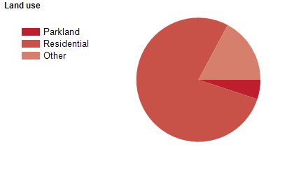
Land use
The City of Norwood Payneham & St Peters is predominantly a residential area, with parklands, reserves, retail/commercial land use and some industrial land use.
Major features
- Major features of the City include St Peter’s College,
- Prince Alfred College,
- Norwood Swimming Centre,
- Payneham Swimming Centre,
- Norwood Oval,
- Norwood Concert Hall,
- St Peters Town Hall,
- Firle Plaza,
- The Parade Norwood Shopping Precinct,
- Magill Road Shopping Strip,
- St Peters River Park and River Torrens Linear Park.
Included areas
- The City of Norwood Payneham & St Peters includes the suburbs of College Park,
- Evandale,
- Felixstow,
- Firle,
- Glynde,
- Hackney,
- Heathpool,
- Joslin,
- Kensington,
- Kent Town,
- Marden,
- Marryatville,
- Maylands,
- Norwood,
- Payneham,
- Payneham South,
- Royston Park,
- Stepney,
- St Morris,
- St Peters and Trinity Gardens.