Nillumbik Shire
About the profile areas
The 2023 Estimated Resident Population for Nillumbik Shire is 63,264, with a population density of 146.4 persons per square km.
Location and boundaries
Nillumbik Shire is located in Melbourne's north-eastern suburbs, about 25 kilometres from the Melbourne CBD. Nillumbik Shire is bounded by Murrindindi Shire in the north, the Yarra Ranges Council area in the east, the Manningham City Council area and the City of Banyule in the south, and the City of Whittlesea in the west. Nillumbik Shire's boundaries are the Kinglake National Park in the north, the Yarra escarpment in the east, the Yarra River in the south, and the Plenty River and Yan Yean Road in the west.
Traditional Owners
The original inhabitants of Nillumbik Shire were the Wurundjeri Aboriginal people.
Name origin
Nillumbik is named from an Aboriginal word thought to mean "shallow earth".
Important
|
Population63,264 2023 ABS ERP |
Land area432.0 square km |
Population density146.4 persons per square km |
Settlement history
European settlement dates from the late 1830s, with land used mainly for grazing, timber-cutting and viticulture. Development was slow until the 1850s and 1860s, spurred by the gold rush, with townships established at Diamond Creek, Panton Hill, Research and St Andrews. From 1870 to 1900 orchards spread along the Diamond Valley, with the prosperity of the fruit growing industry resulting in the townships of Arthurs Creek, Doreen, Plenty and Strathewen. A railway was built to Eltham, and later Hurstbridge in the early 1900s. Sugarloaf Reservoir was constructed in the 1970s, serving as a water storage and treatment plant supplying Melbourne. The most significant residential development occurred in the post-war years, particularly during the 1970s and 1980s. The population continued to increase during the 1990s, with more gradual growth from the early 2000s. The rural areas of the Shire suffered significantly as a result of the Black Saturday bushfires in February 2009, with the loss of approximately 130 dwellings, principally in the townships of Strathewen, St Andrews, Christmas Hills and Arthurs Creek.
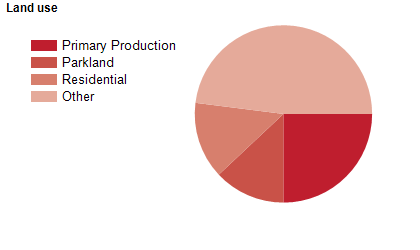
Land use
Nillumbik Shire features both urban and rural areas with undulating hills. The bulk of population is located in the southern and south-western areas, generally comprising Diamond Creek, Eltham, Eltham North, Greensborough, Hurstbridge and Wattle Glen. The major townships are Eltham, Diamond Creek and Hurstbridge. The Shire encompasses a total land area of about 432 square kilometres.
Transport
Nillumbik Shire is served by the Metropolitan Ring Road and the Hurstbridge railway line.
Major features
- Major features of Nillumbik Shire include Kinglake National Park,
- Plenty Gorge Park,
- Sugarloaf Reservoir,
- Warrandyte-Kinglake Nature Conservation Reserve,
- Yering Gorge Bushland Reserve,
- Montsalvat Artists' Colony,
- Eltham Leisure Centre,
- Diamond Valley Sports and Fitness Centre,
- Community Bank Stadium,
- Melbourne Polytechnic (Greensborough Campus),
- Diamond Valley Railway (miniature),
- Edendale Community Environment Farm,
- The Yarra River and numerous wineries.
Included areas
- Nillumbik Shire includes the suburbs and localities of Arthurs Creek,
- Bend of Islands,
- Christmas Hills,
- Cottles Bridge,
- Diamond Creek,
- Doreen (part),
- Eltham,
- Eltham North (part),
- Greensborough (part),
- Hurstbridge,
- Kangaroo Ground,
- Kinglake (part),
- Kinglake West (part),
- North Warrandyte,
- Nutfield,
- Panton Hill,
- Plenty,
- Research,
- Smiths Gully,
- St Andrews,
- Strathewen,
- Watsons Creek,
- Wattle Glen,
- Yan Yean (part) and Yarrambat.