City of Moreton Bay
About the profile areas
The 2023 Estimated Resident Population for the City of Moreton Bay is 510,104, with a population density of 249.4 persons per square km.
Location and boundaries
Moreton Bay is located in south-east Queensland, between 20 and 44 kilometres north of the Brisbane CBD. Moreton Bay is bounded by the Sunshine Coast Council area in the north, the Coral Sea and Moreton Bay in the east, Brisbane City in the south, and the Somerset Regional Council area in the west.
Traditional Owners
The original inhabitants of the Moreton Bay were the Kabi Kabi, Jinibara and Turrbal Aboriginal people.
Name origin
The City of Moreton Bay is named after Moreton Bay, which was named by Captain James Cook after James Douglas, the Earl of Morton.
Important
|
Population510,104 2023 ABS ERP |
Land area2,045 square km |
Population density249.4 persons per square km |
Settlement history
European settlement dates from 1824 when Queensland’s first penal settlement was established at Redcliffe, although this settlement was relocated to Brisbane in 1825. Land was taken up in the 1840s, being used mainly for timber-getting and farming. Population was minimal until the 1860s, when grazing and farming were established (including sugar cane and cotton growing). Growth took place in the 1880s and 1890s, spurred by the opening of the railway line from Brisbane in 1888. Expansion continued during the 1930s. Significant development occurred during the post-war years, particularly from the 1960s. Rapid growth took place during the 1970s and 1980s. The population increased substantially from the early 1990s, rising from about 205,000 in 1991 to about 373,000 in 2011.
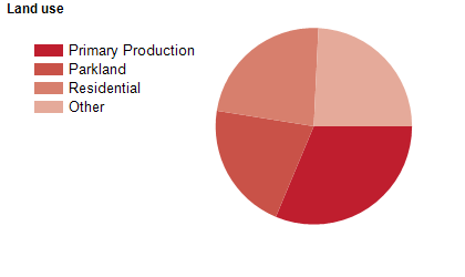
Land use
Moreton Bay is a growing residential area, with substantial rural, rural-residential, commercial and industrial areas. Moreton Bay encompasses a total land area of over 2,000 square kilometres, including mountain ranges, water supply catchments, coastal wetlands, national parks, state forests, rural townships and urban centres. Rural land is used mainly for dairy farming, timber production, beef cattle, mixed farming and tropical fruit growing.
Transport
Moreton Bay is served by the Bruce Highway, the D’Aguilar Highway and the Caboolture and Redcliffe Peninsula railway lines.
Major features
- Major features of the Region include Bellthorpe National Park,
- Bribie Island National Park and Recreation Area,
- D’Aguilar National Park,
- Freshwater National Park,
- Glass House Mountains National Park,
- Bribie Island,
- Moreton Bay Marine Park,
- Pumicestone Passage Marine Park,
- Pumicestone Channel,
- numerous Conservation Parks (Beachmere,
- Buckleys Hole,
- Bullock Creek,
- Bunyaville,
- Byron Creek,
- Clear Mountain,
- Hayes Inlet,
- Samford,
- Sheep Station Creek and Wararba Creek),
- various state forests,
- The Caboolture CBD,
- The Margate CBD,
- Morayfield Shopping Centre,
- Westfield North Lakes Shopping Centre,
- The Redcliffe CBD,
- Strathpine Centre,
- Caboolture Hospital,
- Redcliffe Hospital,
- Moreton Bay Central Sports Complex,
- Lakeside Motor Sport Complex,
- Queensland State Equestrian Centre,
- Redcliffe Paceway,
- Abbey Museum of Art and Archaeology,
- Bribie Island Seaside Museum,
- Caboolture Warplane Museum,
- Pine Rivers Heritage Museum,
- Redcliffe Museum,
- Woodford Museum,
- Redcliffe Cultural Centre,
- Redcliffe City Art Gallery,
- Ocean View Estates Winery,
- Redcliffe Botanic Gardens,
- TAFE Queensland Brisbane (Caboolture and Redcliffe Campuses),
- Queensland University of Technology (Caboolture Campus),
- University of Sunshine Coast (Petrie Campus),
- Lake Samsonvale,
- Lake Kurwongbah,
- Settlement Cove Lagoon,
- The North Pine River,
- The South Pine River and numerous marinas,
- golf clubs,
- sporting facilities,
- parks and beaches.
Included areas
- Moreton Bay includes the suburbs,
- townships and localities of Albany Creek,
- Arana Hills,
- Armstrong Creek,
- Banksia Beach,
- Beachmere,
- Bellara,
- Bellmere,
- Bellthorpe,
- Bongaree,
- Booroobin,
- Bracalba,
- Bray Park,
- Brendale,
- Bribie Island North,
- Bunya,
- Burpengary,
- Burpengary East,
- Caboolture,
- Caboolture South,
- Campbells Pocket,
- Camp Mountain,
- Cashmere,
- Cedar Creek,
- Cedarton,
- Clear Mountain,
- Clontarf,
- Closeburn,
- Commissioners Flat,
- D'Aguilar,
- Dakabin,
- Dayboro,
- Deception Bay,
- Delaneys Creek,
- Donnybrook,
- Draper,
- Eatons Hill,
- Elimbah,
- Everton Hills,
- Ferny Hills,
- Glass House Mountains,
- Godwin Beach,
- Griffin,
- Highvale,
- Jollys Lookout,
- Joyner,
- Kallangur,
- King Scrub,
- Kippa-Ring,
- Kobble Creek,
- Kurwongbah,
- Laceys Creek,
- Lawnton,
- Mango Hill,
- Margate,
- Meldale,
- Moodlu,
- Moorina,
- Morayfield,
- Mount Delaney,
- Mount Glorious,
- Mount Mee,
- Mount Nebo,
- Mount Pleasant,
- Mount Samson,
- Murrumba Downs,
- Narangba,
- Neurum,
- Newport,
- Ningi,
- North Lakes,
- Ocean View,
- Petrie,
- Redcliffe,
- Rocksberg,
- Rothwell,
- Rush Creek,
- Samford Valley,
- Samford Village,
- Samsonvale,
- Sandstone Point,
- Scarborough,
- Stanmore,
- Stony Creek,
- Strathpine,
- Toorbul,
- Upper Caboolture,
- Wamuran,
- Wamuran Basin,
- Warner,
- Welsby,
- White Patch,
- Whiteside,
- Wights Mountain,
- Woodford,
- Woody Point,
- Woorim and Yugar.