City of Merri-bek
About the profile areas
The 2023 Estimated Resident Population for the City of Merri-bek is 181,223, with a population density of 3,557 persons per square km.
Location and boundaries
The City of Merri-bek is located in the inner-northern suburbs of Melbourne, between 4 and 14 kilometres from the Melbourne CBD. The City of Merri-bek is bounded by the Western Ring Road and Hume City in the north, the City of Darebin and Merri Creek in the east, the City of Yarra, the City of Melbourne and Park Street in the south, and the City of Moonee Valley and Moonee Ponds Creek in the west.
Traditional Owners
The original inhabitants of the City of Merri-bek were the Wurundjeri Aboriginal people.
Name origin
The City of Merri-bek is named for the Woi-wurrung word for 'rocky country'. The City's previous name, Moreland, was replaced in 2022 in consultation with the Wurundjeri Woi-wurrung Cultural Heritage Aboriginal Corporation.
Important
|
Population181,223 2023 ABS ERP |
Land area50.94 square km |
Population density3,557 persons per square km |
Settlement history
European settlement dates from the 1830s, with land used mainly for grazing. Population was minimal until the 1850s, with development initially in the southern suburbs of Brunswick and Coburg. Residential growth took place from the 1880s into the early 1900s, aided by industrial growth and the opening of the railway line and tramlines. By the post-war period, development was focused mainly in the northern suburbs. The population increased steadily from the mid 1990s, largely from new housing developments in Gowanbrae, redevelopment of the former Pentridge Prison site in Coburg, and urban renewal in Brunswick and Brunswick East. Population growth is expected to continue.
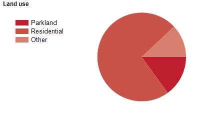
Land use
The City of Merri-bek is predominantly residential, with substantial industrial and commercial areas. The main commercial areas are concentrated along Sydney Road in both Brunswick and Coburg, with smaller retail areas along Lygon Street in Brunswick East and around the railway station at Glenroy. The City encompasses a total land area of 51 square kilometres.
Transport
The City of Merri-bek is served by Citylink, the Western Ring Road, Sydney Road, Bell Street, Brunswick Road, Pascoe Vale Road, the Craigieburn and Upfield railway lines and various tram lines.
Major features
- Major features of the City of Merri-bek include Northern Golf Club,
- Jacana Wetlands,
- Coburg Drive-In Theatre,
- Merri Creek Trail,
- Moonee Ponds Creek Trail,
- The Sydney Road and Lygon Street commercial areas,
- RMIT University (Brunswick Campus),
- CERES Community Environment Park,
- Bain Reserve,
- Clifton Park,
- Coburg Lake Reserve,
- Harmony Park,
- Moomba Park,
- Randazzo Park,
- Brunswick Baths,
- Coburg Leisure Centre,
- Fawkner Leisure Centre,
- Oak Park Aquatic Centre,
- Counihan Gallery,
- Northern Memorial Park and Fawkner Crematorium & Memorial Park.
Included areas
- The City of Merri-bek includes the suburbs of Brunswick,
- Brunswick East,
- Brunswick West,
- Coburg,
- Coburg North,
- Fawkner (part),
- Fitzroy North (part),
- Glenroy,
- Gowanbrae,
- Hadfield,
- Oak Park,
- Parkville (part),
- Pascoe Vale,
- Pascoe Vale South and Tullamarine (part).