Moorabool Shire
About the profile areas
The 2023 Estimated Resident Population for Moorabool Shire is 39,092, with a population density of 18.53 persons per square km.
Location and boundaries
Moorabool Shire is located in south-western Victoria, about 80 kilometres west of the Melbourne CBD. Moorabool Shire is bounded by Hepburn Shire in the north, Macedon Ranges Shire in the north-east, the City of Melton in the east, the City of Wyndham in the south-east, the City of Greater Geelong and Golden Plains Shire in the south, and the City of Ballarat in the west.
Traditional Owners
The original inhabitants of Moorabool Shire were the Dja Dja Wurrung, Wathaurung and Wurundjeri Aboriginal people.
Name origin
Moorabool Shire is named after the Moorabool River, which is thought to be named from an Aboriginal word meaning “haunt or cry of a curlew”.
Important
|
Population39,092 2023 ABS ERP |
Land area2,110 square km |
Population density18.53 persons per square km |
Settlement history
European settlement dates from the 1830s, with growth from the 1850s due to the discovery of gold in Buninyong, Gordon and nearby Ballarat. The townships of Bacchus Marsh and Ballan grew as stopping points for coaches from Melbourne on their way to the goldfields, with Bacchus Marsh becoming the retail centre of the Shire. Significant development has occurred in the Shire in recent decades, particularly in the areas closest to Melbourne, such as Bacchus Marsh, Darley, Hopetoun Park and Maddingley.
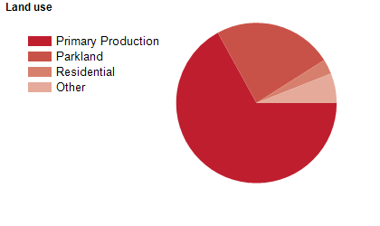
Land use
Moorabool Shire is a growing semi-rural area, with substantial forests, waterways (including water catchments and storages) and growing rural-residential areas. The main township is Bacchus Marsh, with a smaller township at Ballan. The Shire includes numerous other small towns, including Balliang, Balliang East, Barkstead, Blackwood, Bungaree, Clarendon, Dales Creek, Dunnstown, Elaine, Gordon, Greendale, Korweinguboora, Lal Lal, Mount Egerton, Myrniong, Wallace and Yendon. Moorabool Shire encompasses a total land area of 2,110 square kilometres. Most of the northern area is rural, with a large portion being forest. Much of the rural area in the Shire is used for agricultural purposes, including horticulture, sheep and beef farming, timber production and more recently, viticulture. There is also some mining and quarrying.
Transport
Moorabool Shire is served by the Western Freeway, the Midland Highway and the Melbourne-Ballarat railway line.
Major features
- Major features of Moorabool Shire include Brisbane Ranges National Park,
- Lerderderg State Park,
- Werribee Gorge State Park,
- Bungal State Forest,
- Lal Lal State Forest (Bungal Historic Area),
- Wombat State Forest,
- Long Forest Nature Conservation Reserve,
- Lerderderg Gorge,
- Lal Lal Falls,
- Bostock Reservoir,
- Korweinguboora Reservoir,
- Lal Lal Reservoir,
- Merrimu Reservoir,
- Moorabool Reservoir,
- Pykes Creek Reservoir,
- Ballan Mineral Springs,
- Blackwood Mineral Springs,
- Kryal Castle,
- The Village Bacchus Marsh Shopping Centre,
- Rolling Thunder Raceway,
- Bacchus Hill Winery,
- St Anne's Winery and the Bacchus Marsh Avenue of Honour.
Included areas
- Moorabool Shire includes the localities of Bacchus Marsh,
- Ballan,
- Balliang (part),
- Balliang East,
- Barkstead,
- Barrys Reef,
- Beremboke,
- Blackwood,
- Blakeville,
- Bolwarrah,
- Bullarook (part),
- Bullarto South (part),
- Bunding,
- Bungal,
- Bungaree,
- Buninyong (part),
- Cargerie,
- Clarendon,
- Claretown,
- Clarkes Hill,
- Coimadai,
- Colbrook,
- Dales Creek,
- Darley,
- Dunnstown,
- Durham Lead (part),
- Elaine,
- Fiskville,
- Glenmore,
- Glen Park (part),
- Gordon,
- Greendale,
- Grenville (part),
- Hopetoun Park,
- Ingliston,
- Korobeit,
- Korweinguboora (part),
- Lal Lal,
- Leigh Creek,
- Lerderderg,
- Long Forest,
- Maddingley,
- Meredith (part),
- Merrimu,
- Millbrook,
- Mollongghip (part),
- Morrisons (part),
- Mount Doran,
- Mount Egerton,
- Mount Wallace,
- Myrniong,
- Navigators,
- Parwan (part),
- Pentland Hills,
- Pootilla,
- Rowsley,
- Scotsburn (part),
- Spargo Creek,
- Springbank,
- Trentham (part),
- Wallace,
- Warrenheip (part),
- Wattle Flat (part) and Yendon.