City of Monash
About the profile areas
The 2023 Estimated Resident Population for the City of Monash is 203,560, with a population density of 2,500 persons per square km.
Location and boundaries
The City of Monash is located in Melbourne's south-eastern suburbs, between 13 and 24 kilometres south-east of the Melbourne CBD. The City of Monash is bounded by the City of Whitehorse in the north, the City of Knox in the east, the City of Greater Dandenong and the City of Kingston in the south, and the City of Glen Eira, the City of Stonnington and the City of Boroondara in the west. The City of Monash's boundaries are Highbury Road in the north, Dandenong Creek in the east, Police Road, Dandenong Road, Westall Road and Centre Road in the south, and Warrigal Road, North Road, Poath Road, Dandenong Road and Warrigal Road in the west.
Traditional Owners
The original inhabitants of the City of Monash were the Wurundjeri and Boon Wurrung Aboriginal people.
Name origin
The City of Monash is named after a range of features in the area, including Monash University, which were themselves named after World War I commander Sir John Monash.
Important
|
Population203,560 2023 ABS ERP |
Land area81.44 square km |
Population density2,500 persons per square km |
Settlement history
European settlement dates from the 1840s, with land used largely for grazing, market gardens and orchards. The Oakleigh township was established in 1853. Growth took place in the late 1800s, particularly around the railway line to Oakleigh which was constructed in the late 1870s. Except for Oakleigh and Clayton, the area remained largely rural until the 1950s, despite the construction of the Glen Waverley railway line in the 1930s. Small townships such as Glen Waverley, Notting Hill and Mount Waverley serviced the surrounding market gardens, poultry, sheep and cattle farms. Significant residential development took place in the post-war years, accompanied by industrial growth. Areas between the railway lines began to be developed for housing, with rapid growth during the 1960s and 1970s. The population declined slightly during the 1980s and early 1990s, and then increased gradually from the late 1990s, with greater growth in recent years.
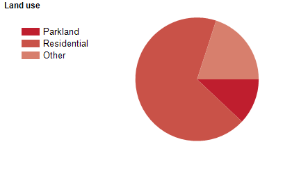
Land use
The City of Monash is a predominantly residential area, with substantial industrial, commercial and recreational areas. The City encompasses a total land area of 81 square kilometres.
Transport
The City of Monash is served by the Monash Freeway, Dandenong Road, North Road, Wellington Road and the Dandenong and Glen Waverley railway lines.
Major features
- Major features of the City of Monash include Monash University (Clayton Campus),
- Federation Training (Chadstone Campus),
- Holmesglen Institute of TAFE (Waverley Campus),
- Victoria Police Academy,
- Monash Medical Centre (Clayton),
- Monash Aquatic and Recreation Centre,
- Jells Park,
- Sir Kennett Luke Stand (Waverley Park),
- Waverley Basketball Centre,
- Waverley Women's Sports Centre,
- Oakleigh Recreation Centre,
- Glen Waverley Golf Course,
- Huntingdale Golf Club,
- Metropolitan Golf Club,
- Oakleigh Golf Course,
- Riversdale Golf Club,
- Robert Blackwood Hall,
- Monash Gallery of Art,
- The Glen Shopping Centre,
- Brandon Park Shopping Centre,
- Clayton Shopping Centre,
- Mount Waverley Village Shopping Centre,
- Oakleigh Central Shopping Centre,
- Waverley Gardens Shopping Centre and the Scotchmans Creek Linear Trail.
Included areas
- The City of Monash includes the suburbs of Ashwood,
- Burwood (part),
- Chadstone,
- Clayton,
- Glen Waverley,
- Hughesdale,
- Huntingdale,
- Mount Waverley,
- Mulgrave,
- Notting Hill,
- Oakleigh,
- Oakleigh East,
- Oakleigh South (part) and Wheelers Hill.