MidCoast Council area
About the profile areas
The 2023 Estimated Resident Population for the MidCoast Council area is 97,909, with a population density of 9.73 persons per square km.
Location and boundaries
The MidCoast Council area is located on the Mid North Coast of New South Wales, in the Hunter Region, about 320 kilometres north of the Sydney CBD. The MidCoast Council area is bounded by the Walcha Council area and the Port-Macquarie Hastings Council area in the north, the Tasman Sea in the east, Port Stephens and the Port Stephens Council area in the south, and Dungog Shire and Upper Hunter Shire in the west.
Traditional Owners
The original inhabitants of the MidCoast Council area were the Biripi and Worimi Aboriginal people.
Important
|
Population97,909 2023 ABS ERP |
Land area10,061 square km |
Population density9.73 persons per square km |
Settlement history
European settlement dates from 1826 when the Australian Agricultural Company began sheep farming. Small settlements were established in the 1830s and 1840s, with timber-getting being an important industry. The township of Wingham was established in 1843 as a river port, and Gloucester in 1855. Some growth took place from the 1870s to the 1890s, aided by the discovery of gold at Copeland, and growth in dairy farming, timber milling and ship building industries. Growth resumed during the early 1900s, spurred by the opening of the north coast railway line in 1913. Significant development occurred in the post-war years, particularly from the 1960s, aided by improved access and tourism, especially in the coastal areas. The population of the Council area increased gradually from the early 1990s, rising from under 71,000 in 1991 to about 85,000 in 2011.
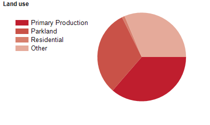
Land use
The MidCoast Council area is predominantly rural, with some residential, industrial and commercial land use. The largest town is Taree, with smaller towns at Forster, Gloucester, Tuncurry and Wingham, and numerous smaller villages and localities. The Council area encompasses a total land area of over 10,000 square kilometres, of which a large proportion is National Park, State Forest and nature reserves, including beaches, coastline, forests, waterways and mountains. Much of the rural area is used for timber production and agriculture, with dairy and beef production being the main agricultural pursuits. Coal mining and oyster farming are also important industries. In more recent years there have been an increasing number of viticulture industries.
Transport
The MidCoast Council area is served by the Pacific Highway, the North Coast railway line and Taree Airport.
Major features
- Major features of the Council area include various National Parks (Barakee,
- Barrington Tops,
- Biriwal Bulga,
- Booti Booti,
- Coorabakh,
- Crowdy Bay,
- Ghin-Doo-Ee,
- Myall Lakes,
- Tapin Tops,
- Wallingat and Woko),
- several State Conservation Areas (Black Bulga,
- Bulahdlelah,
- Coneac,
- Copeland Tops and Curracabundi),
- numerous Nature Reserves (Boondelbah,
- Bretti,
- Brimbin,
- Bugan,
- Camels Hump,
- Coocumbac Island,
- Coolongolook,
- Coxcomb,
- Darawank,
- Goonook,
- John Gould,
- Karuah,
- Khappinghat,
- Khatambuhl,
- Killabakh,
- Mills Island,
- Talawahl,
- The Glen,
- Mernot,
- Monkeycot,
- Regatta Island,
- Towibakh,
- Wallamba,
- Wallis Island,
- Weelah,
- Wingham Brush and Yahoo Island),
- Harrington Beach State Park,
- Manning Entrance State Park,
- Ellenborough Falls,
- Gloucester Falls,
- Nerong Waterholes,
- Newbys Cave,
- Manning Valley River Cruises,
- Killabakh Mountain,
- Myall Lake,
- Smiths Lake,
- Wallis Lake,
- The Manning River,
- Mountain Maid Gold Mine,
- North Coast TAFE (Great Lakes and Taree Campuses),
- The Taree CBD (including Taree Central Shopping Centre and Manning Mall),
- Stockland Forster Shopping Centre,
- The Gloucester CBD,
- Manning Base Hospital (Taree),
- Manning Regional Art Gallery,
- Great Lakes Aquatic and Leisure Centre,
- Manning Aquatic Leisure Centre,
- Taree Recreation Centre,
- Manning Entertainment Centre,
- numerous state forests and beaches,
- various small islands and several wineries.
Included areas
- The MidCoast Council area includes the townships and localities of Allworth,
- Back Creek,
- Bakers Creek,
- Barrington Tops,
- Baxters Ridge,
- Belbora,
- Berrico,
- Bindera,
- Black Head,
- Blueys Beach,
- Bobin,
- Bohnock,
- Bombah Point,
- Boolambayte,
- Boomerang Beach,
- Booral,
- Bootawa,
- Booti Booti,
- Bowman,
- Bowman Farm,
- Bretti,
- Brimbin,
- Bucca Wauka,
- Bulahdelah,
- Bulga Forest,
- Bulliac,
- Bundabah,
- Bundook,
- Bungwahl,
- Bunyah,
- Burrell Creek,
- Cabbage Tree Island,
- Caffreys Flat,
- Callaghans Creek,
- Caparra,
- Carrington,
- Cedar Party,
- Cells River,
- Charlotte Bay,
- Cobark,
- Comboyne (part),
- Coneac,
- Coolongolook,
- Coomba Bay,
- Coomba Park,
- Coopernook,
- Cooplacurripa,
- Copeland,
- Coralville,
- Craven,
- Craven Plateau,
- Crawford River,
- Croki,
- Crowdy Bay National Park,
- Crowdy Head,
- Cundle Flat,
- Cundletown,
- Curricabark,
- Darawank,
- Dewitt,
- Diamond Beach,
- Dingo Forest,
- Dollys Flat,
- Dumaresq Island,
- Dyers Crossing,
- Elands (part),
- Elizabeth Beach,
- Failford,
- Faulkland,
- Firefly,
- Forbesdale,
- Forster,
- Gangat,
- Ghinni Ghinni,
- Giro,
- Girvan,
- Glenthorne,
- Glen Ward,
- Gloucester,
- Gloucester Tops,
- Green Point,
- Hallidays Point,
- Hannam Vale,
- Harrington,
- Hawks Nest,
- Hillville,
- Invergordon,
- Johns River,
- Jones Island,
- Karaak Flat,
- Karuah (part),
- Khatambuhl,
- Kia Ora,
- Killabakh,
- Killawarra,
- Kimbriki,
- Kippaxs,
- Kiwarrak,
- Knorrit Flat,
- Knorrit Forest,
- Koorainghat,
- Krambach,
- Kundibakh,
- Kundle Kundle,
- Langley Vale,
- Lansdowne,
- Lansdowne Forest,
- Limeburners Creek,
- Manning Point,
- Mares Run,
- Markwell,
- Marlee,
- Mayers Flat,
- Melinga,
- Mernot,
- Minimbah,
- Mitchells Island,
- Mograni,
- Mondrook,
- Monkerai,
- Mooral Creek,
- Moorland,
- Moppy,
- Moto,
- Mount George,
- Mungo Brush,
- Myall Lake,
- Nabiac,
- Nerong,
- Nooroo,
- North Arm Cove,
- Number One,
- Old Bar,
- Oxley Island,
- Pampoolah,
- Pindimar,
- Possum Brush,
- Purfleet,
- Rainbow Flat,
- Rawdon Vale,
- Red Head,
- Rookhurst,
- Saltwater,
- Sandbar,
- Seal Rocks,
- Shallow Bay,
- Smiths Lake,
- Stewarts River,
- Stratford,
- Strathcedar,
- Stroud,
- Stroud Road,
- Tahlee,
- Tallwoods Village,
- Tarbuck Bay,
- Taree,
- Taree South,
- Tea Gardens,
- Terreel,
- The Bight,
- The Branch,
- Tibbuc,
- Tinonee,
- Tiona,
- Tipperary,
- Tiri,
- Titaatee Creek,
- Tomalla (part),
- Topi Topi,
- Tugrabakh,
- Tuncurry,
- Upper Karuah River,
- Upper Lansdowne,
- Upper Myall,
- Violet Hill,
- Waitui,
- Wallabi Point,
- Wallanbah,
- Wallingat,
- Wallis Lake,
- Wang Wauk,
- Wards River,
- Warranulla,
- Washpool,
- Waukivory,
- Weismantels,
- Wherrol Flat,
- Whoota,
- Willina,
- Wingham,
- Woko,
- Wootton,
- Yagon and Yarratt Forest.