City of Marion
About the profile areas
The 2023 Estimated Resident Population for the City of Marion is 98,493, with a population density of 1,754 persons per square km.
Location and boundaries
The City of Marion is located in Adelaide's south-western suburbs, about 10 kilometres from the Adelaide CBD. The City of Marion is bounded by the City of West Torrens in the north, the City of Unley and the City of Mitcham in the east, the City of Onkaparinga in the south, and Gulf St Vincent and the City of Holdfast Bay in the west.
Traditional Owners
The original inhabitants of the City of Marion were the Kaurna Aboriginal people.
Name origin
The City of Marion is thought to be named after Miss Marion Fisher, the daughter of the first Resident Commissioner, or after the wife of Colonel Nixon.
Important
|
Population98,493 2023 ABS ERP |
Land area56.17 square km |
Population density1,754 persons per square km |
Settlement history
European settlement dates from 1838 when the Village of Marion was laid out. Land was used mainly for farming, particularly vegetables, almonds, stone-fruits and grapes. There were also mining, quarrying and brick-making industries. Some growth took place from the 1880s into the early 1900s, spurred by the establishment of cement manufacturing in Seacliff Park in 1882. Much subdivision took place in the 1920s, aided by the construction of the tramway and railway line, with housing mainly in the areas closest to the tramline and railway stations. Significant residential development occurred during the post-war years, aided by industrial growth and public housing construction. The population of the City increased from about 11,000 in 1947 to 66,000 in 1966. In the 1960s and 1970s the new suburbs of Hallett Cove, Sheidow Park and Trott Park were developed in the southern area. The population of the City gradually increased from the mid 1990s. Much of the recent growth has been in the southern suburb of Sheidow Park.
Land use
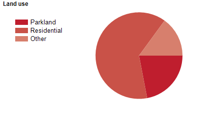
The City of Marion is a predominantly a residential area, with some commercial, industrial and rural areas. The City encompasses a total land area of about 55 square kilometres, including significant conservation areas, recreation parks, rivers and coastline.
Transport
The City of Marion is served by the Southern Expressway, the Noarlunga railway line and the Glenelg-Adelaide tramway.
Major features
- Major features of the City of Marion include Westfield Marion Shopping Centre,
- Warriparinga Wetlands,
- Oaklands Wetland,
- Living Kaurna Cultural Centre,
- Marion Cultural Centre,
- Cove Civic Centre,
- Morphettville Racecourse,
- Warradale Army Barracks,
- O'Halloran Hill Recreation Park,
- Hallett Cove Conservation Park,
- Marino Conservation Park,
- Science Park,
- SA Aquatic & Leisure Centre,
- Marion Outdoor Pool,
- Marion Golf Park,
- The Coast to Vines Rail Trail and Marion Coastal Walk.
Included areas
- The City of Marion includes the suburbs of Ascot Park,
- Bedford Park (part),
- Clovelly Park,
- Darlington (part),
- Dover Gardens,
- Edwardstown,
- Glandore (part),
- Glengowrie,
- Hallett Cove (part),
- Marino,
- Marion,
- Mitchell Park,
- Morphettville,
- O'Halloran Hill (part),
- Oaklands Park,
- Park Holme,
- Plympton Park,
- Reynella (part),
- Seacliff Park (part),
- Seacombe Gardens,
- Seacombe Heights,
- Seaview Downs,
- Sheidow Park (part),
- South Plympton,
- Sturt,
- Tonsley,
- Trott Park and Warradale.

