City of Manningham
About the profile areas
The 2023 Estimated Resident Population for City of Manningham is 129,514, with a population density of 1,143 persons per square km.
Location and boundaries
The Manningham City Council area is located in Melbourne's north-eastern suburbs, commencing with its western boundary in Bulleen, 10 kilometres from the Melbourne CBD and extending to Wonga Park at its eastern extremity, 32 kilometres from the CBD. The Manningham City Council area is bounded by the Yarra River and Nillumbik Shire in the north, the Yarra Ranges Council area in the east, Koonung Creek, the City of Maroondah, the City of Whitehorse and the City of Boroondara in the south, and the City of Banyule and the Yarra River in the north-west.
Traditional Owners
The original inhabitants of the Manningham City Council area were the Wurundjeri Aboriginal people.
Name origin
The Manningham City Council area is named after Manningham Road, which is thought to be named after a region in West Yorkshire, England.
Important
|
Population129,514 2023 ABS ERP |
Land area113.3 square km |
Population density1,143 persons per square km |
Settlement history
European settlement dates from the late 1830s, with land used mainly for orchards, vineyards, dairy farming and wheat and vegetable growing. Growth was minimal until the 1850s when the villages of Doncaster, Templestowe and Warrandyte were established, aided by gold discoveries. Relative isolation from railway lines meant that large-scale residential development did not commence until the post-war period. From the 1950s, there was significant residential development in areas such as Bulleen, Doncaster and Templestowe Lower. This development continued into the 1980s as Doncaster East, Templestowe and Donvale experienced rapid growth. The population increased gradually from mid 1990s, particularly in the suburbs of Doncaster and Doncaster East.
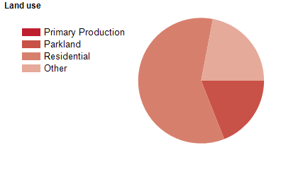
Land use
The Manningham City Council area is an urban and semi-urban area, including normal suburban blocks and low density areas. Generally, areas east of Mullum Mullum Creek are non-urban, while areas to the west are residential. Urban areas include the suburbs of Bulleen, Doncaster, Doncaster East, Templestowe and Templestowe Lower. The non-urban areas include a large tract of the Green Wedge, and are used mainly for rural-residential living, conservation and small scale agriculture (viticulture and grazing).The City encompasses a total land area of about 114 square kilometres, including a substantial 17% green open spaces.
Transport
The Manningham City Council area is served by the Eastern Freeway.
Major features
- Major features of the Manningham City Council area include Warrandyte State Park,
- Ruffey Lake Park,
- The 100 Acres (Flora and Fauna Reserve),
- Westerfolds Park,
- Westfield Doncaster Shopping Centre,
- Stockland The Pines Shopping Centre,
- Kellybrook Winery,
- Yarra Burn Winery,
- Heide Museum of Modern Art,
- Aquarena Aquatic and Leisure Centre,
- The Yarra River and various parklands along the Yarra River.
Included areas
- The Manningham City Council area includes the suburbs of Bulleen,
- Doncaster,
- Doncaster East,
- Donvale,
- Nunawading (part),
- Park Orchards (part),
- Ringwood North (part),
- Templestowe,
- Templestowe Lower,
- Warrandyte,
- Warrandyte South and Wonga Park (part).