Macedon Ranges Shire
About the profile areas
The 2023 Estimated Resident Population for the Macedon Ranges Shire is 52,920, with a population density of 30.29 persons per square km.
Location and boundaries
Macedon Ranges Shire is located in central Victoria, about 60 kilometres north-west of the Melbourne CBD. Macedon Ranges Shire is bounded by Mitchell Shire in the north and east, Hume City, the City of Melton and Moorabool Shire in the south, and Hepburn Shire and Mount Alexander Shire in the west.
Traditional Owners
The original inhabitants of the Macedon Ranges Shire were the Dja Dja Wurrung, Taungurung and Wurundjeri Aboriginal people.
Name origin
Macedon Ranges Shire is named after Mount Macedon, which was named by Major Mitchell in 1836 after Philip of Macedon, in honour of being able to view Port Philip from the summit.
Important
|
Population52,920 2023 ABS ERP |
Land area1,747 square km |
Population density30.29 persons per square km |
Settlement history
European settlement dates from the 1830s, with land used mainly for grazing, particularly sheep farming, but also cattle farming and crop growing. The township of Kyneton was established in the late 1840s. Substantial growth took place from the 1850s due to gold discoveries in nearby Castlemaine and Bendigo. The townships of Gisborne, Lancefield, Macedon, Malmsbury, Riddells Creek, Romsey and Woodend were established during the 1850s. After the gold-rush land was used mainly for agriculture and forestry. The population gradually increased during the 1970s and 1980s, particularly in and around the townships. Population growth took place from the 1990s at a faster rate, with the greatest growth in the towns of Gisborne, Riddells Creek and Romsey, being the townships closest to Melbourne and having a high proportion of workers who commute to Melbourne.
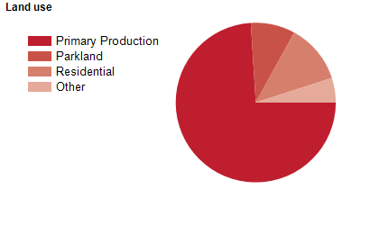
Land use
Macedon Ranges Shire is a semi-rural area, with residential, industrial and commercial land use in a number of townships. The main townships are Gisborne, Kyneton, Lancefield, Macedon, Malmsbury, Mount Macedon, New Gisborne, Riddells Creek, Romsey and Woodend, with some small hamlets and settlements. Rural land is used largely for sheep and cattle grazing and broad-acre cropping, with some horse raising, forestry and viticulture. Tourism is also an important industry. The Shire encompasses a total land area of 1,747 square kilometres.
Transport
Macedon Ranges Shire is served by the Calder Freeway and the Bendigo-Melbourne railway line.
Major features
- Major features of Macedon Ranges Shire include part of Lerderderg State Park,
- Macedon Regional Park,
- Hanging Rock,
- Mount Macedon,
- Hanging Rock Reserve,
- Mount Macedon Memorial Cross Reserve,
- Kyneton Museum,
- NMIT Kyneton Park,
- Lauriston Reservoir,
- Malmsbury Reservoir,
- Rosslynne Reservoir and numerous wineries.
Included areas
- Macedon Ranges Shire includes the localities of Ashbourne,
- Baynton,
- Baynton East,
- Benloch,
- Bolinda,
- Bullengarook,
- Bylands (part),
- Cadello,
- Carlsruhe,
- Cherokee,
- Chintin,
- Clarkefield (part),
- Cobaw,
- Darraweit Guim,
- Denver (part),
- Edgecombe,
- Fern Hill (part),
- Gisborne,
- Gisborne South,
- Goldie,
- Greenhill (part),
- Hesket,
- Kerrie,
- Kyneton,
- Kyneton South,
- Lancefield,
- Lauriston,
- Macedon,
- Malmsbury (part),
- Monegeetta,
- Mount Macedon,
- New Gisborne,
- Newham,
- Pastoria,
- Pastoria East,
- Pipers Creek,
- Riddells Creek,
- Rochford,
- Romsey,
- Sidonia,
- Spring Hill (part),
- Springfield,
- Tantaraboo (part),
- Taradale (part),
- Toolern Vale (part),
- Trentham East (part),
- Tylden (part),
- Woodend and Woodend North.