Livingstone Shire Council area
About the profile areas
The 2023 Estimated Resident Population for Livingstone Shire Council area is 41,906, with a population density of 3.64 persons per square km.
Location and boundaries
Livingstone Shire is located in Central Queensland, about 600 kilometres north of the Brisbane CBD, and about 40 kilometres north-east of the Rockhampton CBD. Livingstone Shire is bounded by the South Pacific Ocean in the north-east and east, the Rockhampton Regional Council area in the south, the Central Highlands Regional Council area in the south-west, and the Isaac Regional Council area in the north-west.
Traditional Owners
The original inhabitants of Livingstone Shire were the Darumbal Aboriginal people.
Name origin
Livingstone Shire is thought to have been named after the County of Livingstone in New South Wales in 1855, which was named after David Livingstone, an African missionary and explorer.
Important
|
Population41,906 2023 ABS ERP |
Land area11,507 square km |
Population density3.64 persons per square km |
Settlement history
European settlement dates from 1850, with land used mainly for sheep and cattle grazing, pineapple and sugar cane growing, orcharding and timber-getting. Several small townships were established in the late 1800s, including Yeppoon in 1867 and Emu Park in the 1870s. Gradual growth took place from the 1880s into the early 1900s, aided by the opening of the railway line and mining. Significant development did not occur until the post-war years, with the population of the Shire rising from about 6,500 in 1947 to nearly 8,000 in 1966. More substantial growth took place from the late 1960s, with the population rising to about 9,600 in 1971, and then to nearly 16,000 in 1981. The population continued to increase from the 1980s, rising to about 19,000 in 1991, to about 26,000 in 2001, and then to about 33,000 in 2011.
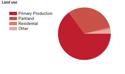
Land use
Livingstone Shire includes significant rural and rural-residential areas and growing urban areas. The Shire encompasses a total land area of about 11,800 square kilometres, including national parks, state forests, coastline, islands and beaches. The main urban centre is Yeppoon, with a smaller urban centre at Emu Park. The Shire is home to numerous small towns and villages, both along the coast and in the rural hinterland, including Byfield, Cawarral, Farnborough, Keppel Sands, Marlborough, Ogmore, Stanage Bay, The Caves and Yaamba. Rural land is used mainly for cattle grazing, pineapple growing, fruit growing, forestry and mining. Tourism is also an important industry.
Transport
Livingstone Shire is served by the Bruce Highway (also known as Kunwarara Road and Yaamba Road).
Major features
- Major features of the Shire include Broad Sound Islands National Park,
- Byfield National Park,
- Capricorn Coast National Park,
- Keppel Bay Islands National Park,
- Mount Archer National Park,
- Mount Etna Caves National Park,
- Mount Jim Crow National Park,
- Great Barrier Reef Marine Park,
- Byfield Conservation Park,
- Causeway Lake Conservation Park,
- various Regional Parks (Charon Point,
- Flat Top Range,
- Keppel Sands,
- Mackenzie Island and Shoalwater Bay),
- Capricorn Caves,
- Mount Etna Caves,
- Shoalwater Bay Military Training Area,
- Central Queensland University (Yeppoon Study Centre),
- Koorana Crocodile Farm,
- Cooberrie Park Wildlife Sanctuary,
- The Keppel Kraken,
- Keppel Bay Marina,
- Great Keppel Island and numerous other small islands,
- The Fitzroy River,
- various state forests,
- numerous beaches and a number of resorts and accommodation places.
Included areas
- Livingstone Shire includes the localities of Adelaide Park,
- Bangalee,
- Barlows Hill,
- Barmaryee,
- Barmoya,
- Bondoola,
- Bungundarra,
- Byfield,
- Canal Creek,
- Canoona,
- Causeway Lake,
- Cawarral,
- Cobraball,
- Cooee Bay,
- Coorooman,
- Coowonga,
- Emu Park,
- Etna Creek,
- Farnborough,
- Glendale,
- Glenlee,
- Greenlake,
- Hidden Valley,
- Inverness,
- Ironpot,
- Jardine,
- Joskeleigh,
- Keppel Sands,
- Kinka Beach,
- Kunwarara,
- Lake Mary,
- Lakes Creek (part),
- Lammermoor,
- Marlborough,
- Maryvale,
- Meikleville Hill,
- Milman,
- Mount Chalmers,
- Mount Gardiner,
- Mulambin,
- Mulara,
- Nankin,
- Nerimbera,
- Ogmore,
- Pacific Heights,
- Rockyview,
- Rosslyn,
- Rossmoya,
- Sandringham,
- Shoalwater,
- Stanage,
- Stockyard,
- Tanby,
- Taranganba,
- Taroomball,
- The Caves,
- The Keppels,
- Thompson Point,
- Tungamull,
- Wattlebank,
- Weerriba,
- Woodbury,
- Yaamba,
- Yeppoon and Zilzie.