City of Knox
About the profile areas
The 2023 Estimated Resident Population for the City of Knox is 161,766, with a population density of 1,421 persons per square km.
Location and boundaries
The City of Knox is located in Melbourne's eastern suburbs, between 20 and 25 kilometres south-east of the Melbourne CBD. The City of Knox is bounded by the City of Maroondah in the north, the Yarra Ranges Council area in the east, the City of Casey in the south, and the City of Monash, the City of Whitehorse and the City of Greater Dandenong in the west. The City of Knox's boundaries are the Dandenong Creek in the north and west, the western boundary of the Dandenong Ranges National Park, Burwood Highway, Royal Street, Wynette Avenue, George Street, Victoria Ridge, Fern Road, New Road, Glenfern Road, Lysterfield Road and the Powells and Casuarina Fire Tracks through Lysterfield Park in the east, and Police Road, the northern boundary of Churchill National Park and a line through Lysterfield Park in the south.
Traditional Owners
The original inhabitants of the City of Knox were the Wurundjeri and Bunurong Aboriginal people.
Name origin
The City of Knox is named after Sir George Knox, former local and state parliamentarian.
Important
|
Population161,766 2023 ABS ERP |
Land area113.8 square km |
Population density1,421 persons per square km |
Settlement history
European settlement dates from 1838 when a cattle run was established in the Rowville and Lysterfield area. Population was minimal until the 1860s, with growth particularly in Bayswater and Ferntree Gully. More substantial growth took place in the late 1800s, spurred by the improved access brought about by the opening of the railway line to Upper Ferntree Gully in 1889. Generally, areas further from the railway line such as Wantirna, Scoresby and Knoxfield developed from the post-war years. Rapid residential growth took place from the 1960s, accompanied by commercial and industrial growth from the 1970s. Rowville and Lysterfield did not experience significant development until the 1980s and 1990s respectively.
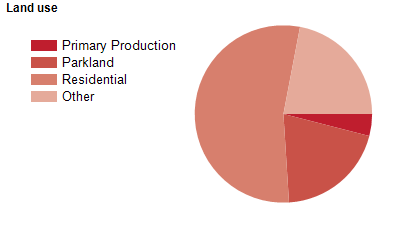
Land use
The City of Knox is a predominantly residential area, with some commercial, industrial and rural areas. The City encompasses a total land area of 114 square kilometres.
Transport
The City of Knox is served by Eastlink, Burwood Highway, Mountain Highway, Stud Road, Wellington Road and the Belgrave railway line.
Major features
- Major features of the City of Knox include Westfield Knox Shopping Centre (including Knox O-Zone),
- Caribbean Gardens Market,
- Angliss Hospital,
- Chesterfield Farm,
- Knox Basketball Stadium,
- Knox Regional Netball Centre,
- Knox Leisureworks (swimming pool),
- Swinburne University of Technology (Wantirna Campus),
- part of the Dandenong Ranges National Park,
- Dandenong Valley Parklands,
- Gilbert Park,
- Kings Park,
- Knox Park,
- Koomba Park,
- Lewis Park,
- Lysterfield Park,
- Marie Wallace Bayswater Park,
- Nortons Park,
- Tim Neville Arboretum,
- Stamford Park Homestead,
- Caribbean Rollerama and National Steam Centre.
Included areas
- The City of Knox includes the suburbs of Bayswater,
- Boronia,
- Ferntree Gully,
- Knoxfield,
- Lysterfield (part),
- Rowville,
- Sassafras (part),
- Scoresby,
- The Basin,
- Upper Ferntree Gully (part),
- Wantirna and Wantirna South.