City of Kalamunda
About the profile areas
The 2023 Estimated Resident Population for the City of Kalamunda is 62,670, with a population density of 193.3 persons per square km.
Location and boundaries
The City of Kalamunda is located in Perth's south-eastern suburbs, about 24 kilometres from the Perth CBD. The City of Kalamunda is bounded by the City of Swan in the north, the Shire of Mundaring in the east, the Cities of Armadale and Gosnells in the south, and the Cities of Canning and Belmont in the west.
Traditional Owners
The original inhabitants of the City of Kalamunda were the Nyungar Aboriginal people.
Name origin
Kalamunda is named from the Aboriginal words "cala" meaning home, and "munnda" meaning forest, thus Kalamunda means "a home in the forest".
Important
|
Population62,670 2023 ABS ERP |
Land area324.2 square km |
Population density193.3 persons per square km |
Settlement history
European settlement dates from the 1860s, with land used mainly for timber-getting, orcharding and farming. Growth took place in the late 1800s and early 1900s, when the Kalamunda township was established and the area became popular as a retreat from city life. The most significant development occurred from the post-war years, particularly during the 1960s and 1970s. The population was relatively stable during the 1990s, and then increased between 2001 and 2011, rising from about 46,000 in 2001 to over 52,000 in 2011.
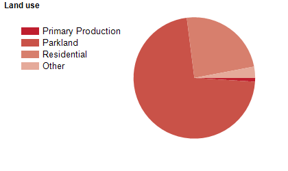
Land use
The City of Kalamunda is a residential and rural area, with some industrial areas. The City encompasses a total land area of 349 square kilometres. The City of Kalamunda includes rapidly growing urban areas in the foothills, such as High Wycombe, Maida Vale and Wattle Grove. Rural land is used mainly for orchards, horticulture, grazing, animal agistment, sawmills and poultry farming.
Transport
The City of Kalamunda is served by the Roe Highway and the Tonkin Highway.
Major features
- Major features of the City include Beelu National Park,
- Gooseberry Hill National Park,
- Kalamunda National Park,
- Korung National Park,
- Lesmurdie Falls National Park,
- Banyowla Regional Park,
- Darling Range Regional Park,
- Mundy Regional Park,
- Victoria Reservoir,
- Hartfield Park,
- Jorgensen Park,
- Pioneer Park,
- Kalamunda History Village,
- Kalamunda Hospital Campus,
- Perth Observatory,
- The Bibbulmun Track,
- Hartfield Golf Club,
- Hill View Public Golf Course,
- Pickering Brook Golf Course,
- The Kalamunda CBD,
- Forrestfield Forum & Marketplace Shopping Centre,
- several state forests and various wineries.
Included areas
- The City of Kalamunda includes the suburbs and localities of Bickley,
- Canning Mills,
- Carmel,
- Forrestfield,
- Gooseberry Hill,
- Hacketts Gully,
- High Wycombe,
- Kalamunda,
- Kewdale (part),
- Lesmurdie,
- Maida Vale,
- Paulls Valley,
- Pickering Brook,
- Piesse Brook,
- Reservoir,
- Walliston and Wattle Grove.