Hornsby Shire
About the profile areas
The 2023 Estimated Resident Population for Hornsby Shire is 154,072, with a population density of 338.5 persons per square km.
Location and boundaries
Hornsby Shire is located in Sydney's northern suburbs - about 25 kilometres from the Sydney CBD. Hornsby Shire is bounded by the Central Coast Council area and the Hawkesbury River in the north and north-east, Cowan Creek in the east, the Ku-ring-gai Council area, the City of Ryde and the City of Parramatta in the south, and The Hills Shire in the west.
Traditional Owners
The original inhabitants of Hornsby Shire were the Darkingung, Dharug and Kuringgai Aboriginal people.
Name origin
Hornsby Shire is named after Police Constable Samuel Horne.
Important
|
Population154,072 2023 ABS ERP |
Land area455.2 square km |
Population density338.5 persons per square km |
Settlement history
European settlement dates from 1794 when the first land grants were made along the Hawkesbury River, with land used mainly for farming. Development was slow, due to limited access. Some growth took place in the 1820s and the 1830s, following the opening of the Great North Road and other tracks. Early industries included citrus and stone fruit farming, salt production, flour mills and boat building. Growth continued in the 1880s and 1890s, especially in the south-eastern section, spurred by the opening of the Newcastle and North Shore railway lines. Hornsby CBD developed as a railway town, becoming the major centre of the Shire. In the 1920s poultry and egg production replaced citrus and stone fruits as the main industry. The most significant development took place from the post-war years, with the most rapid growth during the 1950s and 1960s. From the 1970s population growth began to slow down. The population gradually increased from the 1990s, rising from about 110,000 in 1991 to about 141,000 in 2016. Much of the growth during the 1990s was in the south-western suburbs of Castle Hill, Cherrybrook and Dural, with urban consolidation in and around the Hornsby CBD. Since 2001 there has been considerable medium and high density development (apartments) in the Hornsby CBD and the neighbouring suburb of Waitara.
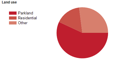
Land use
Hornsby Shire is a predominantly rural and residential area, with some commercial and industrial land use. The Shire encompasses a total land area of about 460 square kilometres, of which two-thirds is National Park and reserves. Most of the land in the northern section is rural. The Shire has two major centres, with a major centre at Hornsby and a secondary centre at Pennant Hills. There are also many suburbs, villages, islands and river communities. Most residential areas are established suburbs, except for Castle Hill, Cherrybrook and Dural, which have developed in more recent decades.
Transport
Hornsby Shire is served by the Pacific Highway, the Sydney-Newcastle Freeway, the Hills (M2) Motorway, Pennant Hills Road and the North Shore, Northern and Central Coast & Newcastle railway lines.
Major features
- Major features of the Shire include Ku-ring-gai Chase National Park,
- Marramarra National Park,
- Berowra Valley Regional Park,
- Dural Nature Reserve,
- Long Island Nature Reserve,
- Muogamarra Nature Reserve,
- Dangar Island,
- Milson Island,
- Asquith Golf Club,
- Pennant Hills Golf Club,
- Westfield Hornsby Shopping Centre,
- Hornsby Mall,
- TAFE NSW Northern Sydney Institute (Hornsby College),
- Hornsby Ku-ring-gai Hospital,
- Koala Park Sanctuary,
- Crosslands Reserve,
- Fagan Park,
- Thornleigh Brickpit Sports Stadium,
- Hornsby Aquatic and Leisure Centre,
- Galston Aquatic and Leisure Centre,
- The Hawkesbury River and the Great North Walk.
Included areas
- Hornsby Shire includes the suburbs and localities of Arcadia,
- Asquith,
- Beecroft (part),
- Berowra,
- Berowra Creek,
- Berowra Heights,
- Berowra Waters,
- Berrilee,
- Brooklyn,
- Canoelands,
- Castle Hill (part),
- Cheltenham,
- Cherrybrook,
- Cowan,
- Dangar Island,
- Dural (part),
- Epping (part),
- Fiddletown,
- Forest Glen,
- Galston,
- Glenhaven (part),
- Glenorie (part),
- Hornsby,
- Hornsby Heights,
- Laughtondale,
- Maroota (part),
- Middle Dural (part),
- Milsons Passage,
- Mount Colah,
- Mount Kuring-gai,
- Normanhurst,
- North Epping,
- Pennant Hills,
- Singletons Mill,
- Thornleigh,
- Wahroonga (part),
- Waitara,
- West Pennant Hills (part),
- Westleigh and Wisemans Ferry (part).