Hawkesbury City
About the profile areas
The 2023 Estimated Resident Population for Hawkesbury City is 68,156, with a population density of 24.55 persons per square km.
Location and boundaries
Hawkesbury City is located at the north-western fringe of the Sydney metropolitan area - about 50 kilometres from the Sydney GPO. Hawkesbury City is bounded by the Singleton Council area and Cessnock City in the north, the Central Coast Council area and The Hills Shire in the east, Blacktown City, Penrith City and Blue Mountains City in the south, and Lithgow City in the west.
Traditional Owners
The original inhabitants of the Hawkesbury area were the Dharug and Darkinjung Aboriginal people.
Name origin
Hawkesbury City is named after the Hawkesbury River, which was named after the Baron of Hawkesbury by Governor Philip in 1789. The Aboriginal name for the river is Deerubbin.
Important
|
Population68,156 2023 ABS ERP |
Land area2,776 square km |
Population density24.55 persons per square km |
Settlement history
European settlement dates from 1794 when 22 farms were established at the settlement on the Hawkesbury River. By 1810 Governor Lachlan Macquarie named four of the five Macquarie Towns in the area: Pitt Town, Richmond, Wilberforce and Windsor (originally The Green Hills). Gradual growth took place from the early 1800s. More substantial growth took place from the 1860s into the early 1900s with improved transport and industry. Significant development occurred in the post-war period, particularly during the 1970s and 1980s. The population increased from nearly 29,000 in 1976 to about 38,000 in 1981, and then to about 50,000 in 1989. The population continued to increase during the 1990s, although at a slower rate, rising from about 51,000 in 1991 to about 61,000 in 2001. The population was relatively stable between 2001 and 2006, and then rose slightly between 2006 and 2011. As of 2011, the finalised estimated resident population (ERP) figure for Hawkesbury City was 64,234 (ABS, Cat. No. 3218.0 - Regional Population Growth, Australia, 2013).
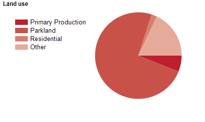
Land use
Hawkesbury City is predominantly comprised of national and state parks, with some residential, commercial, industrial and military land use. The City encompasses a total land area of about 2,800 square kilometres, of which more than 70% is National Park. The Hawkesbury is divided by 5 river systems; the Nepean, Hawkesbury, Grose, Colo and MacDonald rivers. The main population centres are Windsor and Richmond, with urban areas also in many small townships and localities. The majority of the population live in the south-eastern section of the City.
Transport
Hawkesbury City is served by Bells Line of Road, Singleton Road, Wollombi Road, Richmond-Blacktown Road, and the Western railway line.
Major features
- Major features of Hawkesbury City include Blue Mountains National Park,
- Cattai National Park (Mitchell Park),
- Scheyville National Park,
- Wollemi National Park,
- Yengo National Park,
- RAAF Base Richmond,
- Western Sydney University (Hawkesbury Campus),
- TAFE NSW Western Sydney Institute (Richmond College),
- The Windsor and Richmond CBDs (including various shopping centres and malls),
- Parr State Conservation Area,
- Windsor Downs Nature Reserve,
- Yellomundee Regional Park,
- Crago Observatory,
- Pitt Town Lagoon,
- Hawkesbury Race Club,
- Hawkesbury Showgrounds,
- various business and industrial districts,
- numerous accommodation places,
- Hawkesbury District Health Service,
- The Hawkesbury/Nepean River and various ferries.
Included areas
- Hawkesbury City includes the suburbs and localities of Agnes Banks (part),
- Berambing (part),
- Bilpin (part),
- Blaxlands Ridge,
- Bligh Park,
- Bowen Mountain,
- Bucketty (part),
- Cattai (part),
- Central Colo,
- Central Macdonald,
- Clarendon,
- Colo,
- Colo Heights,
- Cornwallis,
- Cumberland Reach,
- East Kurrajong,
- Ebenezer,
- Fernances,
- Freemans Reach,
- Glossodia,
- Grose Vale,
- Grose Wold,
- Higher Macdonald,
- Hobartville,
- Kurmond,
- Kurrajong,
- Kurrajong Heights,
- Kurrajong Hills,
- Leets Vale (part),
- Lower Macdonald,
- Lower Portland (part),
- Maraylya (part),
- McGraths Hill,
- Mellong,
- Mogo Creek,
- Mountain Lagoon,
- Mulgrave,
- North Richmond,
- Oakville,
- Perrys Crossing,
- Pitt Town,
- Pitt Town Bottoms,
- Putty (part),
- Richmond,
- Richmond Lowlands,
- Riverstone (part),
- Sackville,
- Scheyville,
- South Windsor,
- St Albans,
- Ten Mile Hollow (part),
- Tennyson,
- The Devils Wilderness,
- The Slopes,
- Upper Colo,
- Upper Macdonald,
- Vineyard (part),
- Webbs Creek,
- Wheeny Creek,
- Wilberforce,
- Windsor,
- Windsor Downs,
- Wisemans Ferry (part),
- Womerah,
- Wrights Creek and Yarramundi.