Goulburn Mulwaree Council area
About the profile areas
The 2023 Estimated Resident Population for Goulburn Mulwaree Council area is 32,710, with a population density of 10.16 persons per square km.
Location and boundaries
The Goulburn Mulwaree Council area is located in central New South Wales, about 200 kilometres south-west of the Sydney CBD, and 95 kilometres north-east of the Canberra CBD. The Goulburn Mulwaree Council area is bounded by Upper Lachlan Shire in the north and west, Wingecarribee Shire and Shoalhaven City in the east, and the Queanbeyan-Palerang Regional Council area in the south. The Council area's boundaries are Oxley Creek and the Tarlo and Wollondilly Rivers in the north, Uringalla Creek and the Shoalhaven River in the east, and Boro Creek in the south.
Traditional Owners
The original inhabitants of the Goulburn Mulwaree area were various Aboriginal tribes.
Name origin
The Goulburn Mulwaree Council is named after the two former municipalities of Goulburn and Mulwaree. The former Goulburn City was named after Henry Goulburn, British Secretary of State for the Colonies. The former Mulwaree Shire was named after the Mulwaree River.
Important
|
Population32,710 2023 ABS ERP |
Land area3,220 square km |
Population density10.16 persons per square km |
Settlement history
European settlement dates from the 1820s, with the township of Goulburn established in the 1830s. Land was used mainly for grazing and agriculture. Population growth spread to the south of the township from the 1850s, spurred by growth in pastoral industries, the discovery of gold and the opening of the railway line from Sydney in 1869. Expansion continued during the late 1800s, aided by the construction of branch railway lines. Gradual growth took place from the 1960s to the 1990s, with the population increasing from about 21,000 in 1966 to 25,000 in 1991. The population increased slightly from the 1990s, rising to nearly 28,000 in 2011.
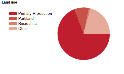
Land use
The Goulburn Mulwaree Council area is predominantly rural, with a city in Goulburn and small villages at Bungonia, Lake Bathurst, Marulan, Tallong and Tarago. The Council area encompasses a total land of over 3,200 square kilometres. Land is used largely for agriculture, particularly sheep grazing, with some cattle grazing and boutique industries.
Transport
The Goulburn Mulwaree Council area is served by the Hume Highway, the Federal Highway and the Southern Highlands (Sydney-Melbourne) railway line.
Major features
- Major features of the Council area include the Goulburn Central Business District,
- Goulburn Square Shopping Centre,
- NSW Police Force Academy,
- TAFE NSW Illawarra Institute (Goulburn Campus),
- Goulburn Base Hospital,
- Goulburn Correctional Centre,
- Goulburn Airport,
- Goulburn Brewery,
- Goulburn Regional Art Gallery,
- Goulburn Rail Heritage Centre,
- Goulburn Historic Waterworks Museum,
- St Clair Villa Museum,
- Goulburn Aquatic and Leisure Centre,
- Wakefield Park Raceway,
- Goulburn Recreation Area (including Goulburn Paceway,
- Goulburn Greyhound Racing Track and Goulburn Showground),
- Goulburn Golf Club,
- Tully Park Early Birds Golf Club,
- Kingsdale Wines,
- Rocky Hill Memorial Park & War Memorial,
- Victoria Park,
- Morton National Park and Bungonia State Conservation Area.
Included areas
- The Goulburn Mulwaree Council area includes the townships and localities of Baw Baw,
- Boxers Creek,
- Brayton (part),
- Brisbane Grove,
- Bungonia,
- Carrick,
- Currawang (part),
- Goulburn,
- Greenwich Park (part),
- Gundary,
- Kingsdale,
- Lake Bathurst,
- Lower Boro,
- Marulan,
- Middle Arm (part),
- Mummel,
- Oallen (part),
- Parkesbourne,
- Pomeroy (part),
- Quialigo,
- Run-O-Waters,
- Tallong (part),
- Tarago (part),
- Tarlo (part),
- Tirrannaville,
- Towrang,
- Wayo (part),
- Windellama,
- Wollogorang (part),
- Woodhouselee (part) and Yarra.